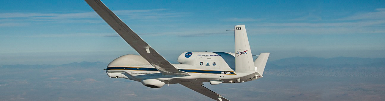
Official websites use .gov
A .gov website belongs to an official government organization in the United States.

Secure .gov websites use HTTPS
A lock ( ) or https:// means you’ve safely connected to the .gov website. Share sensitive information only on official, secure websites.

The OAR ORTA UxSRTO is no longer operating.
For further information, please contact ORTA at ORTA@noaa.gov.

Sensing Hazards With Operational Unmanned Technology (SHOUT)

Ocean Observations

Targeted observations from aircraft in oceanic regions could significantly improve how well weather models forecast significant events such as (1) tropical storms, (2) winter storms and (3) major floods. The long duration and large oceanic areas that can be observed using advanced UxSRTO such as the Global Hawk make this UxSRTO a potentially important observing platform, for environmental assessment and forecasting.

Mission Description

The NOAA UxSRTO Program has designed a project focused on sensing high impact weather-related hazards called “Sensing Hazards with Operational Unmanned Technology (SHOUT)”. The project to sense high impact weather hazards will

  • Partner with NASA to conduct missions for operational prototype data collection
  • Be utilized for both observing and predicting high impact oceanic weather
  • Determine the utility of UxSRTO data in prediction of dangerous storms that can affect the United States
  • Quantify the influence of UxSRTO environmental data to high impact weather prediction
  • Determine best observing strategies
  • Assess the operational effectiveness of UxSRTO to mitigate the satellite data gap
  • Begin with a targeted observing effort using NASA Global Hawk platforms and payloads
  • As the project matures, consider other viable unmanned observing technologies may be incorporated into the observing strategies as operational prototypes

People of interest — Management Team

Principal Investigator • Philip Hall, NOAA UxSRTO Program Director
Project Managers • Philip Kenul, TriVector Services • JC Coffey, Cherokee Nation Technologies
Project Scientists • Michael Black, NOAA OAR AOML • Gary Wick, NOAA OAR ESRL • Jason Dunion, NOAA OAR AOML HRD


Contact information for Team members

Instrumentation

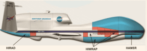
Instrument package payloads to be used on the SHOUT missions

  • NOAA: AVAPS — Advanced Vertical Atmospheric Profiling System developed by NCAR, dozens of dropsondes for deployment at altitudes up to 65,000 ft from the unmanned Global Hawk aircraft collect high vertical resolution measurements of the temperature, pressure, relative humidity, and wind speed and direction in the atmosphere
  • NASA: HIWRAP — High-Altitude Imaging Wind and Rain Airborne Profiler, radar designed to examine the factors of storm intensity: formation, structure and intensification
  • NASA JPL: HAMSR — High Altitude MMIC Sounding Radiometer an atmospheric sounder intended for aircraft deployment is a microwave temperature and humidity sounder instrument that looks at the microwave spectrum and was designed and built at the Jet Propulsion Laboratory
  • NASA GHRC: LIP — CAMEX-4 ER-2 Lightning Instrument Package consists of eight state of the art digital electric field mills and a dual-tube Gerdien conductivity probe; These field mills allow the determination of the vector components of the electric field to improve our knowledge of the electrical structure

SHOUT Data Management and Archive

The NOAA UxSRTO Data Management Plan (DMP) was developed within the framework of the Environmental Data Management Committee (EDMC) for handling UxSRTO instrumentation package data and covers acquisition, ingest, quality control, integration, visualization and archiving. Recommendations from that plan were used to prototype and demonstrate all phases of the UxSRTO data lifecycle from real-time operations to post analysis and research (Figure Below).

New data distribution and web-based visualization tools accessed using the NASA MTS and NOAA GTS, in addition to quick access links, provided the capability for users to dynamically toggle on-and-off the various observation layers, adjust layer transparency, and visualize Global Hawk observations along with various satellite observations. Post flight, data was grouped and made available for further analysis allowing users to access previous observations.

During SHOUT 2016, the project made improvements to existing operational and research data ingest, and archival strategies, in addition to improvements to integration and visualization through the provision of several new real-time products by the instrument teams within MTS, initial efforts to archive of data in the Meteorological Assimilation Data Ingest System (MADIS), and team coordination. MADIS, a NWS operational system, provides near real-time data pathways to NOAA operational and research systems, as well as the greater meteorological community is a potential pathway to operations and archive of Global Hawk observations. Once the Global Hawk data sets are fully realized in MADIS, users may access the data through MADIS interfaces or NOAA’s Data Catalog. However, to view text, xml, or csv observations user will need to download the MADIS API.

Real-time data sets were made available on the NASA MTS and SHOUT websites throughout the mission. Meteorological observations were placed into GTS, and the SHOUT NRD-94 ‘minisonde’ in-situ data were assimilated into a variety of both operational and research NWP forecast models (Table Below). Because of the criticality of providing accurate input for such applications, especially into operational NWP models, heavy emphasis was placed on quality assurance and processing of all utilized observations.

Summary of model data use from the SHOUT 2016 campaign

NWP Forecast Model NameModel Type: Operational -vs- ResearchDomain TypeSource Nation / Institution
Hurricane Weather Research and Forecasting (HWRF)OperationalRegionalU.S. / NOAA Hurricane Research Division (HRD)
Coupled Ocean/Atmosphere Mesoscale Prediction System (COAMPS)OperationalRegionalU.S. / Navy
Navy Global Environmental Model (NAVGEM)OperationalGlobalU.S. / Navy
European Centre for Medium-Range Weather Forecasts (ECMWF)OperationalGlobalEurope (independent intergovernmental)
United Kingdom Meteorological (UKMET) ModelOperationalGlobalUnited Kingdom
Hurricane Weather Research and Forecasting System – Research version (HWRFx)ResearchRegionalU.S. / NOAA Hurricane Research Division (HRD)
Weather Research and Forecasting Model – Advanced Research version (WRF-ARW)ResearchRegionalU.S. /Pennsylvania State University and the National Center for Atmospheric Research (NCAR)
Fifth-Generation Mesoscale Model (MM5)ResearchRegionalU.S. / Pennsylvania State University and the National Center for Atmospheric Research (NCAR)


Active data on the current project is available from the following three web addresses:

HS3 Project (select Data Products)
NOAA Meteorological Assimilation Data Ingest System (MADIS)
NOAA SHOUT Preliminary Data Archive