Article / Figures Provided By: Dr. Jessica Cherry
Duration: 36 months (07/01/19 – 07/01/22)
Principal Investigator: Dr. Jessica Cherry1,3
Co-I: Mr. Crane Johnson1,3
Collaborator: Mr. Jeff Cotterman2,3
1Alaska-Pacific River Forecast Center
2Alaska Aviation Weather Unit
3Alaska Environmental Science and Services Integration Center
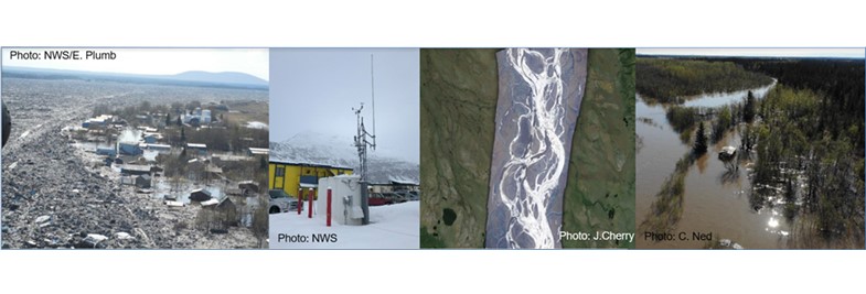
In Alaska, flooding is the most frequent cause of state disaster declarations. Ice jam floods during spring break-up have devastated many communities along waterways in the large Yukon and Kuskokwim River basins over the past century. Snowmelt and heavy precipitation can cause flooding in the spring and summer time. Alaska also faces frequent impacts from the outbursts of glacially dammed lakes. For many years, the Alaska-Pacific River Forecast Center (APRFC) has depended on partners to help monitor flood conditions in remote communities on the ground or in small aircraft. Building in-house capabilities to deploy small Unmanned Aerial Systems, helps bring cutting edge data collection to the decision-support services at the National Weather Service.
Starting in July 2019, a team from NWS Alaska including the APRFC and the Alaska Aviation Weather Unit has been testing the ability of the of the Government Edition DJI Mavic Pro and Matrice 600 UAS to map flooding and other hydrologic conditions, as well as conduct routine inspections of meteorological towers. This NOAA-funded work builds on airborne research that the Principal Investigator, Dr. Jessica Cherry, did while in her previous position at the University of Alaska.
“As a scientist and a commercial airplane pilot, I’m used to interpreting water conditions from the air,” Cherry said. “Building a UAS program will be a powerful new tool for our group, and may someday be used across the National Weather Service.” Other team members Crane Johnson and Jeff Cotterman have strong backgrounds in programming and technology development.
Support from NOAA’s UAS Program Office is helping the team acquire aircraft with optical and thermal infrared cameras and collect data across the state of Alaska. Photographs will be mosaicked into maps and three-dimensional surfaces using a computer vision technique known as Structure from Motion. This technique, and images acquired during and after flooding, will be used to estimate inundated areas and volumes of water. Differential GPS survey equipment will be used for collecting ground control. These photos, maps, and volume estimates will provide tools for forecasters to better predict the impacts of different types of flooding in communities across Alaska, particularly in ungauged basins.
Over the next three years, the team hopes to establish training protocols, mission plan templates, and operational risk management workflows that could serve as a pilot program for other NWS field offices.
“We will be learning every step of the way, but we will also have an opportunity to build new partnerships in the UAS community and with the public, who are the ultimate users of our flood and meteorological products,” Cherry said.