
NOAA Announces $6.4 Million in Funding for Innovative Uncrewed Systems Projects
Uncrewed aircraft and marine systems have great potential to enhance and expand the ways that NOAA meets its mission to understand and predict changes in climate, weather, ocean and coasts. NOAA’s Uncrewed Systems Operations Center (UxSOC) and Uncrewed Systems Research Transition Office (UxSRTO) are partnering to support and facilitate the research, development and transition to operations of uncrewed systems (UxS) across the agency. To that end, the two NOAA offices are funding 12 innovative projects, with a focus on
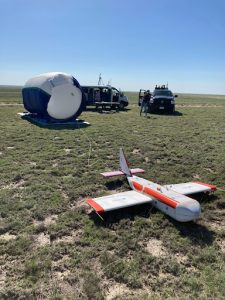
High-altitude Operational Returning Unmanned System (HORUS) Acquires Measurements at Altitude of 90,000 ft (MSL)
Principal Investigator: Dr. Colm Sweeney and Co-Principal Investigator: Dr. Bianca Baier (GML) The NOAA Global Monitoring Laboratory (GML) AirCore has revolutionized high-altitude trace gas sampling to ~30 km (> 98% of atmosphere) in the past decade. These trace gas profiles provide valuable information for satellite validation and understanding of atmospheric composition in the lower-middle stratosphere that are unreachable by most aircraft. The AirCore — a 100-m long coiled tube — is a passive whole-air sampling

NOAA Model Incorporates sUAS Data for First Time to Improve Hurricane Forecasts
For over 30 years, NOAA has utilized reconnaissance aircraft to obtain measurements within tropical cyclones (TCs), including hurricanes in the Atlantic and Gulf of Mexico. These platforms have proven extremely valuable for furthering TC research and improving forecasts. Any data that improves tropical cyclone forecasts in turn improves tropical cyclone watches, warnings, and relevant evacuation information.
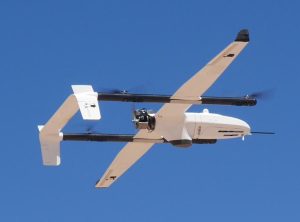
The recent advent of small Uncrewed Aircraft Systems (sUAS) are being evaluated for their potential to enhance the reconnaissance data gathered by NOAA by operating in hazardous regions where conventional aircraft cannot fly.
NOAA Completes FVR-55 Operations in Marine Stratocumulus Clouds to Measure Atmospheric Aerosol Properties needed to Improve Climate Model Simulations
Between August 8th and 18th, 2022, the NOAA Pacific Marine Environmental Laboratory (PMEL) and the University of Washington Cooperative Institute for Climate, Ocean, and Ecosystem Studies (CICOES) used the L3Harris Fixed Wing Vertical Takeoff and Landing Rotator (FVR-55) uncrewed aerial system (UAS) to measure aerosol and cloud vertical profiles with the NOAA Clear Sky and Cloudy Sky scientific payloads (descriptions provided below). The sensors in the payloads measure aerosol properties relevant to aerosol direct radiative forcing and aerosol – cloud interactions. The mission was supported, in part, by NOAA’s Earth Radiation Budget (ERB) program that was initiated to investigate natural and human activities that might alter the reflectivity of marine boundary clouds. The UAS measurements reported here will provide critical information on the processes that lead to the brightening of marine clouds with a potential cooling of the Earth’s surface.
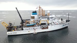
NOAA Alaska Fisheries Science Center’s Ice Seal Research in the Eastern Bering Sea Aboard the NOAA Ship Oscar Dyson
NOAA’s Alaska Fisheries Science Center’s (AFSC) studies Alaska’s marine ecosystems to ensure the sustainable use and conservation of living marine resources in federal waters. A recent study done by NOAA scientists focuses on surveying ice seals, with the primary goal of deploying non-invasive, low-disturbance methods for monitoring the body condition of Arctic seals as an indicator of population health and productivity. This work complements and expands the capabilities of NOAA’s existing large-area photographic surveys to monitor Arctic seal populations and their responses to a rapidly changing environment. The methods and techniques developed throughout this project will greatly enhance NOAA Fisheries capabilities to assess the status and trends of bearded, ringed, spotted, ribbon, and harbor seals in Alaska, as well as meet the agency’s responsibilities under the Marine Mammal Protection Act (MMPA) and Endangered Species Act (ESA). From April 8th-25th 2022, researchers with the The Polar Ecosystems Program (PEP) embarked on the NOAA AFSC ice seal research expedition aboard the NOAA Ship Oscar Dyson in the eastern Bering Sea.
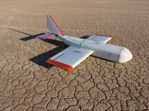
HORUS is Approved to Fly in the National Airspace in Northeastern Colorado
Uncrewed aerial systems (UAS) have long been heralded for their unique potential to sample the upper atmosphere at much lower costs and in environments unreachable by most aircraft. However, under normal flight rules, NOAA UAS can only fly up to 1,200 feet above ground level in the national airspace.
NOAA Global Monitoring Laboratory has recently obtained approval from the Federal Aviation Administration (FAA) to fly the High-altitude Operational Returning Unmanned System (HORUS) up to 90,000 ft above mean sea level (MSL) in the national airspace in northeastern Colorado.
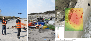
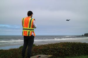
Marine Debris Detection with UAS, Machine Learning, and Polarimetric Imaging
Marine debris, human-made material that is discarded or abandoned into the marine environment, is a pervasive problem plaguing shorelines around the world. Marine debris poses serious threats to wildlife, degrades coastal and marine environments, and can negatively impact the Blue Economy (e.g., tourism, shipping, and fisheries). NOAA’s Marine Debris Program (MDP), as the U.S. Federal lead for assessment, prevention, and removal of debris, works with partners across the Nation to conduct debris shoreline surveys to identify debris accumulations, locations, and sources as part of the Marine Debris Monitoring and Assessment Project (MDMAP). Data from these surveys have been used to assess spatial and temporal trends in shoreline debris, inform behavior change campaigns focusing on specific items and assess the effectiveness of legislation targeting specific items. In this project, NOAA’s National Centers for Coastal Ocean Science (NCCOS), NOAA’s MDP, and Oregon State University (OSU) partnered to investigate three emerging technologies with the potential to transform how marine debris shoreline surveys are conducted: uncrewed aircraft systems (UxS), machine learning, and polarimetric imaging (PI) cameras.
This innovative technology and corresponding operations were funded and supported by the OAR Uncrewed Systems Research Transition Office (UxSRTO).
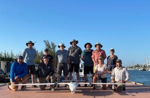
NOAA Completes FVR-55 Shipboard Launch/Recovery Operations to Measure Atmospheric Aerosols and Fluxes needed to Improve Climate Model Simulations
During the month of March 2022, the NOAA Pacific Marine Environmental Laboratory (PMEL) and Physical Sciences (PSL) Laboratories used a newly developed uncrewed aircraft system (UAS) to better understand the chemical and physical characteristics of the atmosphere. The suite of sensors used in these demonstrations will improve climate and weather models by providing unique information about the atmosphere.
In partnership with L3Harris Technologies, an American technology company, NOAA has used the newly developed FVR-55 (Fixed Wing Vertical Takeoff and Landing Rotator) UAS to conduct shipboard launch and recovery operations for collecting atmospheric data with the NOAA “Clear Sky,” “Cloudy Sky,” and “miniFlux'' scientific payloads. Development of this innovative technology was initially funded through a NOAA Phase I Small Business Innovation Research (SBIR) award in 2016, followed by a Phase II SBIR award and follow-on contract for the continued development of the UAS. Continued development and operations were funded and logistically supported by both the OAR Uncrewed Systems Research Transition Office (UxSRTO) and the OMAO UxS Operations Center (UxSOC). Participants from PMEL, PSL, UxSRTO, UxSOC, and L3Harris performed 11 fully autonomous ship-launching and landing flight operations (14.9 hours of total flight time) off Key West, FL to test and demonstrate the scientific payloads.
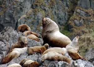
Use of Artificial Intelligence (AI) to Monitor Steller Sea Lion Populations
Every year, Alaska Fisheries Science Center’s Marine Mammal Laboratory of NOAA Fisheries uses crewed and uncrewed systems to conduct aerial surveys of known Steller sea lion sites across Alaska. These surveys are essential to monitoring the endangered western population of Steller sea lions in Alaska. While the population as a whole has begun to show signs of recovery, one region in the westernmost part of the population range has declined 94% in the last 40 years (showing no signs of recovery), and rookeries – sites where sea lions mate, give birth, and rest – have begun to disappear. In the Gulf of Alaska, anomalous warm water events beginning in 2014 are becoming more commonplace and are likely causing the observed declines in the area – an area which was previously showing signs of sea lion population recovery and began to increase in 2002.
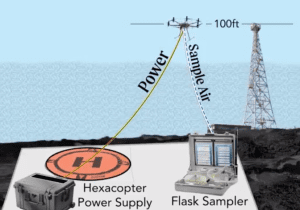
NOAA Global Monitoring Laboratory Development of a UAS “Virtual Tower” for Gas and Ozone Measurements
Scientists from NOAA’s Global Monitoring Laboratory (GML) have undertaken novel development of an uncrewed aircraft system (UAS) “hexacopter” that will enable the lab to not only recommence a long-standing mission that was recently forced to halt, but paves the way toward enhanced operations in the future. The composition of Earth’s atmosphere is rapidly changing due to anthropogenic releases of carbon dioxide (CO2) and methane (CH4), which are powerful greenhouse gasses driving global warming. Also, human-made chemicals such as CFC-11 and CFC-12 (refrigerants) are destroying the ozone layer that filters out ultraviolet (UV) radiation. These CFCs and their counterparts destroy enough of the protective stratospheric ozone layer to produce the Antarctic “Ozone Hole”.
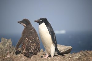
First Beyond Visual Line of Sight (BVLOS) UAS Mission to Map and Count Penguins in Antarctica
A key mission of the Antarctic Ecosystem Research Division (AERD) at NOAA Fisheries’ Southwest Fisheries Science Center (SWFSC) is to develop an understanding of how an international krill fishery operating in Antarctic waters may impact other Antarctic wildlife that consume the main target of this fishery: Antarctic krill (Euphausia superba). Three species of brush-tailed penguins (Pygocelis spp.) nesting in the South Shetland Islands off the Antarctic Peninsula primarily or exclusively consume Antarctic krill. Over the last three decades AERD scientists have monitored the number of penguin chicks raised each year by Adelie (Pygocelis adeliae), Gentoo (Pygocelis papua), and Chinstrap (Pygocelis antarcticus) penguin as one important indicator of how these populations are responding to natural variability and to the impacts of the krill fishery.
During this project Dr. Trevor Joyce, a contractor affiliated with the SWFSC’s Marine Mammal and Turtle Division, and Dr. Jefferson Hinke from AERD flew a series of Uncrewed Aerial Systems (UAS) missions at AERD’s Copacabana Field Camp on King George Island, Antarctica (62.178°S, 58.446°W) using the FireFly6 Pro fixed-wing vertical take-off and landing (VTOL) UAS. The purpose of these flights was to collect very high-resolution aerial images (0.7-1.2 cm ground sampling resolution) of the penguin colonies in order to count the number of penguin chicks produced in the current breeding season.
NOAA and Duke University Examine UAS-based Approaches for Coastal Wetland Monitoring
Project team: NOAA National Centers for Coastal Ocean Science (NCCOS), Duke University Marine Robotics Laboratory and Remote Sensing Laboratory, North Carolina National Estuarine Research Reserve (NERR) and North Inlet-Winyah Bay NERR.
The core mission of NOAA’s National Ocean Service (NOS) includes stewardship of sensitive coastal habitats like those of the National Estuarine Research Reserve System (NERRS), a collection of 29 sites nationwide where NOS and States partner to promote research, education, and preservation of estuarine ecosystems. Unmanned Aerial Systems (UAS) can improve tidal wetland monitoring by providing high spatial resolution and coverage, with customizable sensors, at user-defined times.
This NOS National Centers for Coastal Ocean Science (NCCOS) research project, supported by the NOAA Uncrewed Systems Research Transition Office (UxSRTO), develops methods for the incorporation of Uncrewed Aircraft Systems (UAS) to expand routine wetland monitoring programs like those conducted by the National Estuarine Research Reserve System (NERRS).
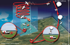
NOAA GML Scientists Successfully Test the “High-Altitude Operational Returning Uncrewed System” Glider with AirCore Science Package to 75,000 feet MSL
Recent flight testing of the “High-altitude Operational Returning Uncrewed System” (HORUS) at NASA’s Armstrong Flight Research Center and Edwards Air Force Base, California between May 13-25, 2021 marks a huge success within NOAA. Scientists from

NOAA PSL and L3Harris Complete miniFlux Payload Integration and Flight Tests
With funding and logistical support from the NOAA Oceanic and Atmospheric Research (OAR) Uncrewed Systems Research Transition Office (UxSRTO), in addition to the NOAA Pacific Marine Environmental Laboratory (PMEL) Clear and Cloudy Sky payloads, the NOAA OAR Physical Sciences Laboratory (PSL), together with partners at the Cooperative Institute for Research in Environmental Sciences (CIRES) and Integrated Remote and In Situ Sensing (IRISS) program at the University of Colorado Boulder developed the miniFlux sensor suite for operation on the L3Harris Latitude Fixed Wing Vertical Takeoff and Landing (VTOL) Rotator (FVR-55). miniFlux is a collection of complementary systems and sensors selected to provide robust and accurate measurements of atmospheric thermodynamic and kinematic states. miniFlux carries sensors to make redundant measurements of temperature, humidity, and pressure, in addition to nadir and zenith thermal IR temperatures and sensors to provide a three dimensional wind measurement. In combination, these measurements, combined with accurate inertial position and orientation measurements collected by the miniFlux system, enable for estimation of atmospheric energy transfer conditions.
On May 6, 2021 L3Harris and PSL successfully completed payload integration and flight testing at the Florence, AZ test flight area. The miniFlux was mounted on the wing of the FVR-55.
Final engineering checkout is planned with L3Harris Latitude FVR-55 and NOAA PMEL and PSL payloads on the Commercial 96' vessel TowBoatU.S. Richard L. Becker,
NOAA PMEL and L3Harris Complete Cloudy Sky and Clear Sky Payload Integration and Flight Tests
As a continuation of the research, the NOAA Oceanic and Atmospheric Research (OAR) UxS Research Transition Office awarded L3Harris a Phase III follow-on contract for the continued development of the FVR-55. This contract is to support shipboard operations and scientific payload integration on the FVR-55. Flight tests were completed on February 17, 2020 off the M/V Richard L. Becker out of Fort Lauderdale, FL to demonstrate autonomous takeoff and recovery from a moving vessel at-sea. L3Harris completed all objectives and demonstrated fully autonomous flight using Hybrid Quadrotor (HQ) technology from a moving ship with limited deck space.
On March 22-26, 2021 the NOAA PMEL team joined the L3Harris staff at their facility in Tucson, AZ to complete bench and initial flight testing (Florence, AZ test flight area) of the Cloudy and Clear Sky payloads to verify the payloads functionality. The two payloads measure the aerosol and cloud properties required for the observation of aerosol direct radiative effects (Clear Sky payload) and impacts of aerosols on clouds (Cloudy Sky Payload).