


NOAA Announces $6.4 Million in Funding for Innovative Uncrewed Systems Projects
Uncrewed aircraft and marine systems have great potential to enhance and expand the ways that NOAA meets its mission to understand and predict changes in climate, weather, ocean and coasts. NOAA’s Uncrewed Systems Operations Center (UxSOC) and Uncrewed Systems Research Transition Office (UxSRTO) are partnering to support and facilitate the research, development and transition to operations of uncrewed systems (UxS) across the agency. To that end, the two NOAA offices are funding 12 innovative projects, with a focus on
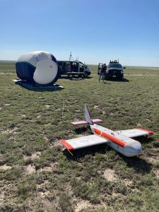
High-altitude Operational Returning Unmanned System (HORUS) Acquires Measurements at Altitude of 90,000 ft (MSL)
Principal Investigator: Dr. Colm Sweeney and Co-Principal Investigator: Dr. Bianca Baier (GML) The NOAA Global Monitoring Laboratory (GML) AirCore has revolutionized high-altitude trace gas sampling to ~30 km (> 98% of atmosphere) in the past decade. These trace gas profiles provide valuable information for satellite validation and understanding of atmospheric composition in the lower-middle stratosphere that are unreachable by most aircraft. The AirCore — a 100-m long coiled tube — is a passive whole-air sampling

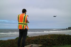
NOAA Model Incorporates sUAS Data for First Time to Improve Hurricane Forecasts
For over 30 years, NOAA has utilized reconnaissance aircraft to obtain measurements within tropical cyclones (TCs), including hurricanes in the Atlantic and Gulf of Mexico. These platforms have proven extremely valuable for furthering TC research and improving forecasts. Any data that improves tropical cyclone forecasts in turn improves tropical cyclone watches, warnings, and relevant evacuation information.
The recent advent of small Uncrewed Aircraft Systems (sUAS) are being evaluated for their potential to enhance the reconnaissance data gathered by NOAA by operating in hazardous regions where conventional aircraft cannot fly.