
Article and Figures Provided By: Trevor Joyce (NOAA Affiliate – SWFCC/MMTD)
Duration: 29 months (05/31/19 – 09/30/21)
Principal Investigator: Dr. David Weller (Dr. John Durban)
Co-Investigator: Dr. Trevor Joyce
U.S. Department of Commerce
National Oceanic and Atmospheric Administration
Southwest Fisheries Science Center / Marine Mammal and Turtle Division
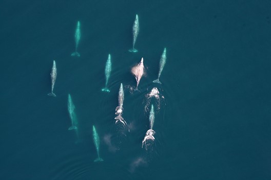
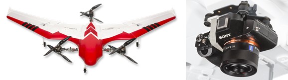
Gathering data on the size of marine wildlife populations and better understanding the risks human activities pose to these populations are core responsibilities of NOAA Southwest Fisheries Science Center / Marine Mammal and Turtle Division. In this study, supported by the UAS Program Office, scientists will be evaluating the use of a fixed-wing UAS platform with vertical take-off and landing (VTOL; Firefly6 Pro, BirdsEyeView Aerobotics, Inc.). This VTOL would be used as a tool to collect photographic data on gray whales (Eschrichtius robustus) migrating past a long-running monitoring site at Granite Canyon, California in January of 2020 and 2021 (Figure 1). Counts of gray whales using UAS photographs will be validated against simultaneous counts from shore-based visual observers, and counts of whale blows detected in a shore-based thermal infrared camera system. In addition, imagery collected during these flights will provide a high-resolution permanent record that can be audited after the survey, and may potentially yield other information on group size, demographic composition, and body condition.
The goal of this research and development effort is to evaluate the use of a fixed-wing UAS platform to accurately count whales, with a long-term objective of providing an alternative to manned aerial surveys which are costly and pose an element of risk to the safety of pilots and onboard observers. Once validated, a potential application of this survey tool would be the estimation of fishing gear densities and large whale migratory passage rates in entanglement hotspots. This would help NOAA Fisheries evaluate population-level risks posed by different types of fishing gear. As longer range missions become more feasible from a technical and regulatory standpoint, and image processing becomes more streamlined, other potential uses of this UAS survey tool include estimating local marine mammal densities to facilitate NOAA Fisheries permitting consultations on naval exercises, shipping lane modifications, and renewable energy leases (Figure 2).
