Article and Figures Provided By: Kenneth Vierra (Science Technology Corporation/UxS Research Transition Office), Patricia Quinn (NOAA/PMEL), Janet Intrieri (NOAA/PSL)
During the month of March 2022, the NOAA Pacific Marine Environmental Laboratory (PMEL) and Physical Sciences (PSL) Laboratories used a newly developed uncrewed aircraft system (UAS) to better understand the chemical and physical characteristics of the atmosphere. The suite of sensors used in these demonstrations will improve climate and weather models by providing unique information about the atmosphere.
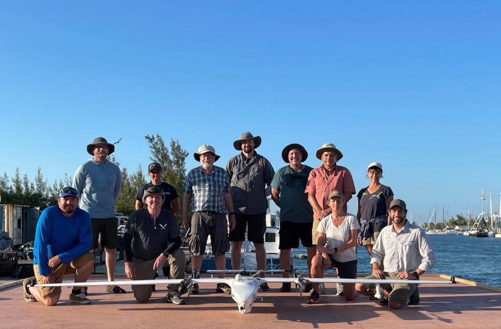
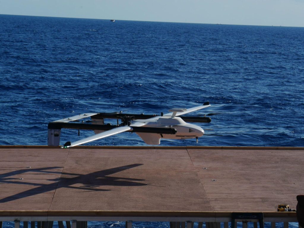
In partnership with L3Harris Technologies, an American technology company, NOAA has used the newly developed FVR-55 (Fixed Wing Vertical Takeoff and Landing Rotator) UAS to conduct shipboard launch and recovery operations for collecting atmospheric data with the NOAA “Clear Sky,” “Cloudy Sky,” and “miniFlux” scientific payloads. Development of this innovative technology was initially funded through a NOAA Phase I Small Business Innovation Research (SBIR) award in 2016, followed by a Phase II SBIR award and follow-on contract for the continued development of the UAS. Continued development and operations were funded and logistically supported by both the OAR Uncrewed Systems Research Transition Office (UxSRTO) and the OMAO UxS Operations Center (UxSOC). Participants (Figure 1) from PMEL, PSL, UxSRTO, UxSOC, and L3Harris performed 11 fully autonomous ship-launching and landing flight operations (14.9 hours of total flight time) off Key West, FL to test and demonstrate the scientific payloads.

The NOAA Florida Keys National Weather Service Team provided morning and evening atmospheric and sea forecast conditions in the operation areas. These updates provided the field team with critical situational awareness, enabling the group to determine where best to operate based on local conditions.
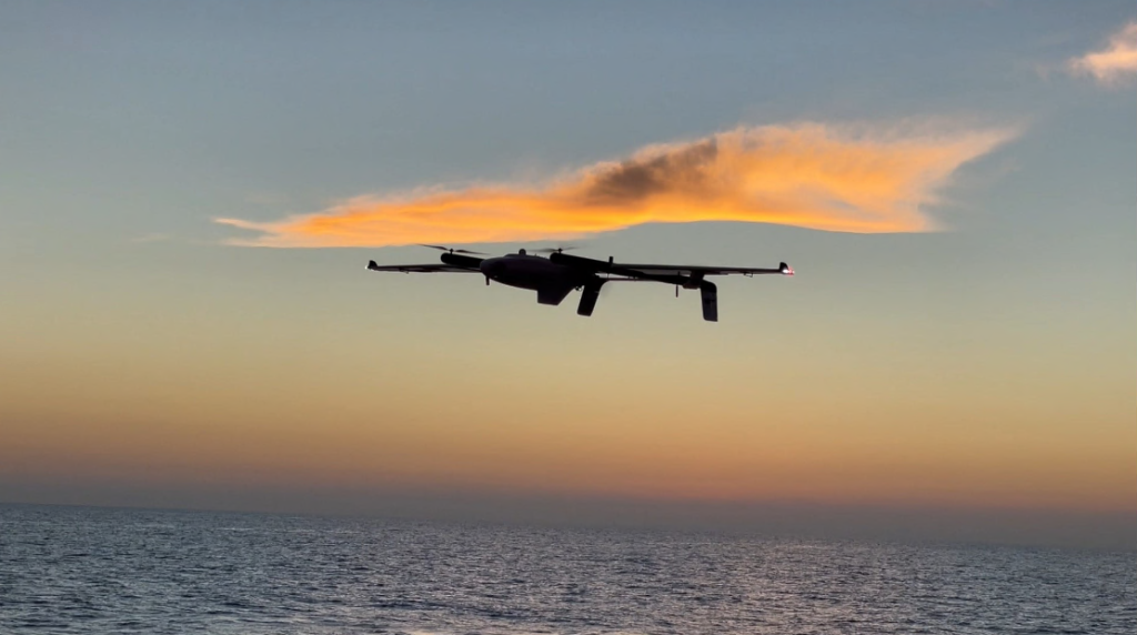
During these operations, L3Harris completed the objectives and demonstrated fully autonomous flight using Hybrid Quadrotor (HQ) technology from a moving ship with limited deck space (Figure 2/Video). The FVR-55 took off from the ship vertically, switched to fixed wing flight, and returned and landed vertically on the ship autonomously (no external pilot control inputs required). As mentioned, a total of 11 flights were conducted, 8 with payloads. Flight duration with the payloads ranged from 60 to 183 minutes. Altitudes up to 1100 ft, constrained by required visual line of sight operations, were attained. The estimated range of wind speeds was 10 to 16 knots with seas of 1 to 2 ft.
NOAA PMEL developed two payloads to measure the aerosol and cloud properties required for the observation of aerosol direct radiative effects (Clear Sky payload) and impacts of aerosols on clouds (Cloudy Sky Payload). The degree to which aerosol direct forcing and interactions between aerosols and clouds are cooling the planet and offsetting warming by greenhouse gases is highly uncertain. According to the Intergovernmental Panel on Climate Change (IPCC), climate forcing associated with aerosol-cloud interactions contributes the largest uncertainty to total radiative forcing estimates. Vertical profiles of aerosol and cloud properties are required to improve models and decrease uncertainties, particularly over the ocean due to the susceptibility of marine clouds to small changes in aerosol concentrations.
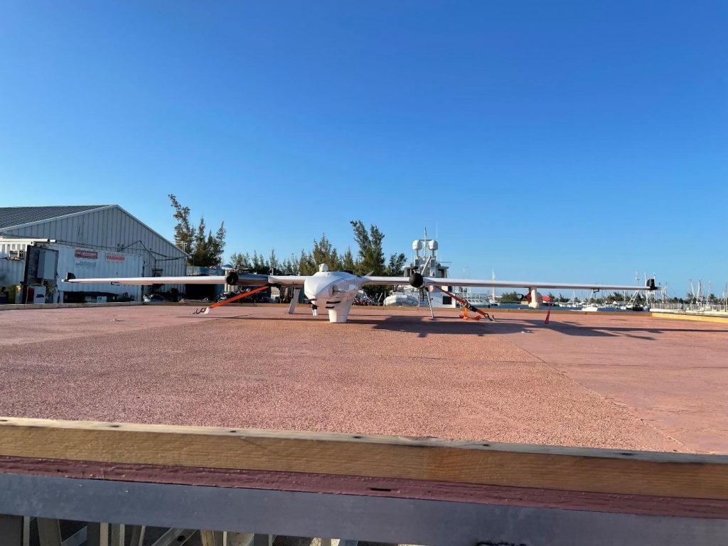
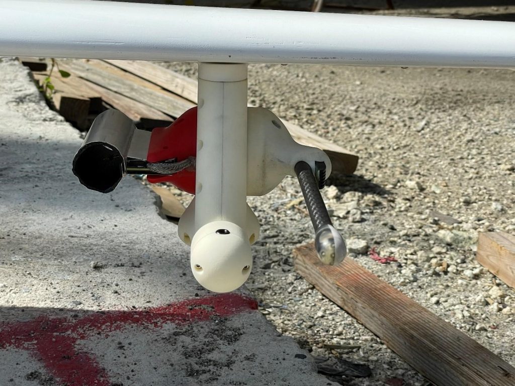
The Clear Sky payload (Figure 3) is designed to measure the direct radiative effect in the atmospheric column up to ~3 km (1.86 miles), specifically aerosol optical depth and phase function of scattered light. The Cloudy Sky payload is designed to look at the relationship between aerosol number, concentration, and particle size below and above the cloud, and cloud droplet number concentration within the cloud.
Clear Sky and Cloudy Sky payloads make measurements of aerosol and cloud properties that are needed to improve climate model simulations of the impact of aerosols on climate. Scattering and absorption of solar radiation by atmospheric aerosol particles affect Earth’s radiation budget, including cooling at the Earth’s surface. In addition, aerosol particles take up water and form cloud droplets which can increase cloud brightness and lead to a cooling of the Earth’s surface.
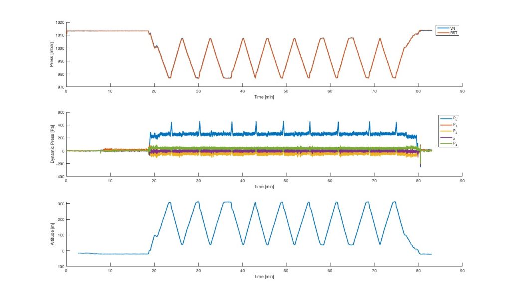
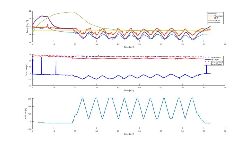
The NOAA PSL miniFlux is a collection of complementary systems and sensors selected to provide robust and accurate measurements of atmospheric thermodynamic and kinematic states. MiniFlux (Figure 5A) carries sensors to make redundant measurements of temperature, humidity, and pressure, in addition to nadir and zenith thermal IR temperatures and sensors to provide a three-dimensional wind measurement. These measurements, combined with accurate inertial position and orientation measurements collected by the miniFlux system, enable for estimation of atmospheric energy transfer conditions.
Example miniFlux data from the March 9, 2022 flight is shown in Figures 5B (pressures) and 5C (temperatures). All miniFlux flights were co-flown with the Clear Sky nose cone measurement payload. The level 1 data of the variety of temperature and pressure were in good agreement and all sensors performed well. Level 2 and final data with any needed quality-control and calculated variables are in process.
A large component of forecast uncertainties results from improper model physics. Therefore, improving the representation of physical processes and ultimately, physical parameterizations, is a critical step towards better predictive skill across the weather and climate timescales. High quality measurements of lower atmospheric state and turbulent fluxes over a variety of environments, including those that are difficult to reach over the remote ocean, is one of the critical observations needed for assessing and improving coupled model physics.
The miniFlux measurements can directly contribute to advancing scientific understanding relevant to NOAA forecasting efforts across the weather and climate timescales. Specifically, information on the vertical distribution of dynamic (momentum) and thermodynamic fields (heat fluxes), spatial and temporal variation of planetary boundary layer (PBL) height, formation, and maintenance of clouds, and PBL stability can be used to evaluate boundary layer and cloud parameterizations. Understanding the physical processes supporting the organization of clouds and providing guidance on model physics development is one of the major goals articulated in NOAA’s Unified Forecast System (UFS) Goals and Priorities document. In response, NOAA Physical Sciences Laboratory (PSL), Environmental Modeling Center (EMC), Geophysical Fluid Dynamics Laboratory (GFDL), Global Systems Division (GSD) and others are presently involved in the testing and evaluation of UFS model physics.
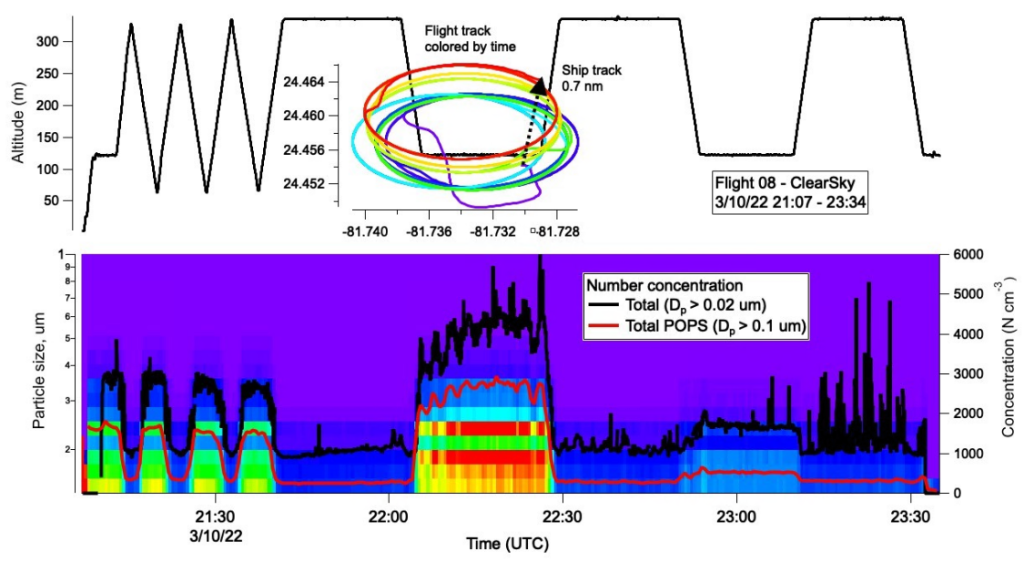
Data from Flight 08 with the Clear Sky payload are shown in Figure 6 with altitude and flight path in the top panel and particle number concentration and size distribution in the bottom panel. The flight track involved circles initially alternating between 70 and 320 m and then between 120 and 330 m (top). The ship transited 0.7 nm during the flight. The condensation particle counter (CPC) onboard observed elevated concentrations up to 5,000 cm-3 during the lower altitude circles, indicating an aerosol layer from the surface up to ~120 m. Concentrations measured by the Portable Optical Particle Spectrometer (POPS) were lower, reaching up to 2,000 cm-3, due to the measurement of a narrower size range (particles with diameters greater than 0.1 micron. Over this size range, particles were present from 0.1 to ~0.5 micron (bottom).
Data from Flight 06 with the Cloudy Sky payload are shown in Figure 7. Again, flight altitude and track are shown in the top panel along with cloud liquid water content from the Cloud Droplet Probe. As no clouds were penetrated, liquid water content was negligible. The plane flew to 330 m (1082.68 ft) and performed circles. The ship transited 0.7 nm during the flight (top). The miniature Scanning Electrical Mobility Spectrometer (mSEMS) measures particles with diameters greater than 0.01 microns, a broader size range than detected by the POPS. Initially, particle concentrations were ~3,000 cm-3 but increased to 8,000 cm-3 thirty minutes into the flight. Particles were present between about 0.05 microns and the upper limit size limit (0.3 microns) of the mSEMS.

The NOAA UxS Program’s goal is to potentially transition the FVR-55 UAS from research to operations on NOAA vessels. OAR/PMEL is in the initial planning stages for UxS operations between June – September 2022 to support NOAA’s Earth Radiation Budget (ERB) Initiative using the L3Harris FVR-55 with measurements using the Cloudy Sky and Clear Sky (Figure 8/Video) payloads based from a ship or coastal site.