Official websites use .gov
A .gov website belongs to an official government organization in the United States.

Secure .gov websites use HTTPS
A lock ( ) or https:// means you’ve safely connected to the .gov website. Share sensitive information only on official, secure websites.

The OAR ORTA UxSRTO is no longer operating.
For further information, please contact ORTA at ORTA@noaa.gov.
Slider_01
NOAA Uncrewed Systems Research Transition Office
OLYMPUS DIGITAL CAMERA
Research Areas
Evaluate observing strategies
Address critical data gaps
Facilitate UxSRTO application
Evaluate ship-launched UxSRTO technology and infrastructure
Develop extended visual line of site operations
Analyze the value of high-altitude observations
Develop UxSRTO CONOPS for conducting pinniped survets in remote regions
OLYMPUS DIGITAL CAMERA
Research Areas
To facilitate UxSRTO applications and utilization
Accelerate transition of UxSRTO capabilities from research to operations
Provide expertise and resources for UxSRTO research and development
Slider_04
previous arrow
next arrow

Uncrewed Systems Research Transition Office

What We Do

Uncrewed Systems Research Transition Office (UxSRTO) can revolutionize NOAA’s ability to monitor and understand the global environment. There is a key information gap today between instruments on Earth’s surface and on satellites – UxSRTO can bridge that gap. Operated by remote pilots and ranging in wingspan from less than six feet to more than 115 feet, UxSRTO can also collect data from dangerous or remote areas, such as the poles, oceans, wildlands, volcanic islands, and wildfires. Better data and observations improve understanding and forecasts, save lives, property, and resources, advancing NOAA’s mission goals.

Operated remotely, UxSRTO can collect critical observations from dangerous or remote areas, such as the poles, oceans, wildlands, storm damaged areas, volcanic islands, and wildfires. Demonstrating extraordinary capabilities for acquiring data in such challenging environments, matured UxSRTO technologies provide a transformative capacity to enable NOAA’s scientists to better perform their missions. UxSRTO advances NOAA’s goals of preserving lives, property, and environmental resources by enhancing scientific understanding, increasing forecast accuracy, and providing safer, more efficient earth and wildlife observations.

NOAA’s Alaska Fisheries Science Center’s (AFSC) studies Alaska’s marine ecosystems to ensure the sustainable use and conservation of living marine resources in federal waters.  A recent study done by NOAA scientists focuses on surveying ice seals, with the primary goal of deploying non-invasive, low-disturbance methods for monitoring the body condition of Arctic seals as an indicator of population health and productivity. During April 2022, researchers with the The Polar Ecosystems Program (PEP) embarked on the NOAA AFSC ice seal research expedition aboard the NOAA Ship Oscar Dyson in the eastern Bering Sea. (Video/Credit: AFSC). Read more in our article, click here.

Check Out Our Newest Videos

Check Out the Highlights of UxSRTO

The UxS Research Transition Office (UxSRTO) is helping NOAA realize the potential these systems offer by supporting innovative research and development (R&D) of UxS technologies across NOAA’s broad mission space.

Current Highlights

What's Happening In the News

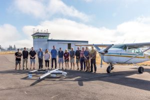
NOAA Completes FVR-55 Operations in Marine Stratocumulus Clouds to Measure Atmospheric Aerosol Properties needed to Improve Climate Model Simulations

Between August 8th and 18th, 2022, the NOAA Pacific Marine Environmental Laboratory (PMEL) and the University of Washington Cooperative Institute for Climate, Ocean, and Ecosystem Studies (CICOES) used the L3Harris Fixed Wing Vertical Takeoff and Landing Rotator (FVR-55) uncrewed aerial system (UAS) to measure aerosol and cloud vertical profiles with the NOAA Clear Sky and Cloudy Sky scientific payloads (descriptions provided below). The sensors in the payloads measure aerosol properties relevant to aerosol direct radiative forcing and aerosol – cloud interactions. The mission was supported, in part, by NOAA’s Earth Radiation Budget (ERB) program that was initiated to investigate natural and human activities that might alter the reflectivity of marine boundary clouds. The UAS measurements reported here will provide critical information on the processes that lead to the brightening of marine clouds with a potential cooling of the Earth’s surface.

Read More »

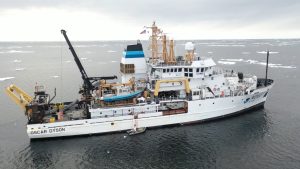
NOAA Alaska Fisheries Science Center’s Ice Seal Research in the Eastern Bering Sea Aboard the NOAA Ship Oscar Dyson

NOAA’s Alaska Fisheries Science Center’s (AFSC) studies Alaska’s marine ecosystems to ensure the sustainable use and conservation of living marine resources in federal waters.  A recent study done by NOAA scientists focuses on surveying ice seals, with the primary goal of deploying non-invasive, low-disturbance methods for monitoring the body condition of Arctic seals as an indicator of population health and productivity. This work complements and expands the capabilities of NOAA’s existing large-area photographic surveys to monitor Arctic seal populations and their responses to a rapidly changing environment. The methods and techniques developed throughout this project will greatly enhance NOAA Fisheries capabilities to assess the status and trends of bearded, ringed, spotted, ribbon, and harbor seals in Alaska, as well as meet the agency’s responsibilities under the Marine Mammal Protection Act (MMPA) and Endangered Species Act (ESA). From April 8th-25th 2022, researchers with the The Polar Ecosystems Program (PEP) embarked on the NOAA AFSC ice seal research expedition aboard the NOAA Ship Oscar Dyson in the eastern Bering Sea.

Read More »
High-altitude Operational Return Unmanned System (HORUS). Photo Credit: Sonja Wolter|GML&CIRES.

HORUS is Approved to Fly in the National Airspace in Northeastern Colorado

Uncrewed aerial systems (UAS) have long been heralded for their unique potential to sample the upper atmosphere at much lower costs and in environments unreachable by most aircraft. However, under normal flight rules, NOAA UAS can only fly up to 1,200 feet above ground level in the national airspace.

NOAA Global Monitoring Laboratory has recently obtained approval from the Federal Aviation Administration (FAA) to fly the High-altitude Operational Returning Unmanned System (HORUS) up to 90,000 ft above mean sea level (MSL) in the national airspace in northeastern Colorado.

Read More »