
UAS PROGRAM CONDUCTS A POST MISSION REVIEW FOR QUANTIFYING RESTORATION OF JUVENILE SALMON HABITAT WITH AN UNMANNED AERIAL VEHICLE SYSTEM (UAV).
On April 26th, 2018, NOAA’s Fisheries, The Department of Energy’s Pacific Northwest National Laboratory, National Park Service, Ryka UAS and the NOAA UAS Program Office conducted a post mission for Dr. Curtis Roegner’s Hyperspectral Salmon Habitat Study conducted 2016-17. The following was discussed and had multi-user interest:
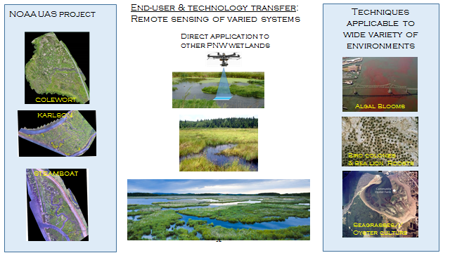
Project Scope
- Wetlands directly benefit endangered juvenile salmon by supporting diverse vegetation communities.
- Restoration of degraded wetlands leads to vegetation and topographic changes that require comprehensive monitoring – difficult to accomplish w/traditional means.
- Develop remote sensing techniques employing hyperspectral imagery on a uav to monitor wetland restoration trajectories.
Project Goals
- Equip a UAV system with a hyperspectral imager – completed
- Conduct field measurements, and build Spectral Library – completed
- Develop data analysis routines and analytics for critical metrics -completed
- Test flight optimization and evaluation missions at additional tidal wetland systems – completed
- Codify protocols for remote sensing to aid evaluation of wetland restoration trajectories and management decision making – completed
This project which included 2016-17 missions have brought federal, academic and industry partners together to provide an integrated DJI Matrice 600 UAS with a complex pushbroom hyperspectral imager (BaySpec OCI-100 BP150) which were able to distinguishing vegetation types in a complex wetland environment . Also, a spectral library has been developed and can be expanded to capture vegetation and possibly wildlife phenology.
Conclusions
- Successful implementation of a complex high-sensitivity sensor on a UAS platform
- Traditionally, vibration and variable stability of a UAS platform have made these kinds of collections extremely difficult to use.
- Hyperspectral sensor is key to distinguishing vegetation types in a complex wetland environment
- Processing methodologies have been developed and exercised, though still more validation and testing to be done
- Seasonal spectral library has been developed to capture vegetation phenology
The team enjoyed the increased affordability, flexibility, resolution and weather adaptability of using UAS for this application. Additionally, using UAS reduced the time to mission execution because the team was able to quickly execute system integration, and were properly trained, proficient and understood the difficulties in flying in this complex environment.