Official websites use .gov
A .gov website belongs to an official government organization in the United States.

Secure .gov websites use HTTPS
A lock ( ) or https:// means you’ve safely connected to the .gov website. Share sensitive information only on official, secure websites.

John Coffey

The NCAR/NOAA Global Hawk Dropsonde System

Wick et al. accepted for publication in J. Atmos. Oceanic Technol. A new system enabling the remote deployment of up to 90 dropsondes from the NASA Global Hawk unmanned aircraft was developed through a partnership between the National Center for Atmospheric Research (NCAR) and NOAA. The dropsonde is an instrument, about the size of an empty paper towel roll, that measures the temperature, pressure, and humidity of the atmosphere along with the wind speed and […]

The NCAR/NOAA Global Hawk Dropsonde System Read More »

NOAA UAS Program Well Represented at the AUVSI XPONENTIAL Conference in Denver.

AUVSI XPONENTIAL 2018 is the largest, most comprehensive trade show for unmanned systems and robotics. This year's show was held in Denver from April 30th to May 3rd, and was attended by 8,500 thought leaders from across the spectrum of unmanned systems and robotics to share ideas, gain insight and witness groundbreaking innovation.  This year's program included several themes including “Unmanned for Good” which covered unmanned systems used in the wake of multiple hurricanes, wildfires and other natural disasters last year.  Unmanned systems across all domains became widely recognized as the future of disaster relief. From search and rescue to humanitarian missions, unmanned technologies were utilized around the world providing aid to those who needed it most.

The Unmanned Aerial System (UAS) Weather Forum was held on April 30th and provided a platform for UAS operators; federal and state agencies; weather researchers and providers; trade groups; safety and insurance groups; UAS manufacturers; and others to:

– Share experiences with expected and unexpected weather impacts
– Engage in a dialogue about weather needs for UAS operations
– Collect requirements for developing better weather guidance
– Cultivate strategies on how to make progress with needed weather support
– Assist regulators with safe integration of UAS into the national airspace system considering weather impacts
– Explore opportunities for using UAS-sensed environmental information for enhanced situational awareness and better weather prediction
– Facilitate weather education & outreach

Chris Hernandez, Sector Vice President, Research, Technology & Engineering, Northrop Grumman gave the final keynote on, and presented the long term view of unmanned technology, reviewing the development of unmanned systems in the military context for 8 decades.  Hernandez pointed out that through cooperation with the military and other technology providers, unmanned technology has advanced – and close cooperation between government and industry is what will be required to continue development.  He also discussed NOAA and NASA's use of the Global Hawk for hazardous weather research.

John “JC” Coffey chaired three technical sessions included Beyond-Visual-Line-of-Sight (BVLOS) briefs, and Phil Kenul presented on ASTM's F38 organization and structure, current status of the standards developed in support of all Civil Aviation Authority’s (CAA) efforts to integrate UAS into their nation’s airspace (attached) with several members of the NOAA team in attendance.

Additional information on the conference can be found at: https://www.xponential.org/xponential2018/public/Enter.aspx

NOAA UAS Program Well Represented at the AUVSI XPONENTIAL Conference in Denver. Read More »

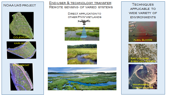
Dr. Curtis Roegner, Ph.D from NOAA’s Fisheries Uses Unmanned Aerial Vehicle System (UAS) for Hyperspectral Imagery

On April 26th, 2018, NOAA's Fisheries, The Department of Energy's Pacific Northwest National Laboratory, National Park Service, Ryka UAS and the NOAA UAS Program Office conducted a post mission for Dr. Curtis Roegner’s Hyperspectral Salmon Habitat Study conducted 2016-17.  The following was discussed and had multi-user interest:

Project Scope

  1. Wetlands directly benefit endangered juvenile salmon by supporting diverse vegetation communities.
  2. Restoration of degraded wetlands leads to vegetation and topographic changes that require comprehensive monitoring – difficult to accomplish w/traditional means.
  3. Develop remote sensing techniques employing hyperspectral imagery on a uav to monitor wetland restoration trajectories.

Project Goals

  1.  Equip a UAV system with a hyperspectral imager – completed
  2.  Conduct field measurements, and build Spectral Library – completed
  3.  Develop data analysis routines and analytics for critical metrics -completed
  4.  Test flight optimization and evaluation missions at additional tidal wetland systems – completed
  5.  Codify protocols for remote sensing to aid evaluation of wetland restoration trajectories and management decision making – completed    

Dr. Curtis Roegner, Ph.D from NOAA’s Fisheries Uses Unmanned Aerial Vehicle System (UAS) for Hyperspectral Imagery Read More »

NOAA UAS Program Hosts National Tribal Interest Group for UAS Webinar

The NOAA UAS Program and DOI’s Bureau of Indian Affairs (BIA) co-hosted the quarterly meeting of the Tribal Interest Group for UAS on April 19th. The NOAA UAS Program and DOI’s Bureau of Indian Affairs (BIA) co-hosted the quarterly meeting of the Tribal Interest Group for UAS on April 19th. Several tribal and non-tribal representatives were present and discussed current Native American UAS operations, future concepts of operations and STEM opportunities.  The Bureau of Indian

NOAA UAS Program Hosts National Tribal Interest Group for UAS Webinar Read More »

NOAA Evaluates Drones to Map Coastline and Nearshore Waters

Last month, NCCOS scientists and their partners tested the utility of drone technology to map the coastline and nearshore waters of St. Croix in the U.S. Virgin Islands. The team evaluated the quality of land elevation and water depth data acquired by three different drones under a variety of conditions. Several agencies, including NOAA, need land elevation and water depth data to inform management decisions about the coastal zone. However, many nearshore areas are difficult to

NOAA Evaluates Drones to Map Coastline and Nearshore Waters Read More »