

Article and Figures Provided By: Jenny Davis (NOS/NCCOS)
Project team: NOAA National Centers for Coastal Ocean Science (NCCOS), Duke University Marine Robotics Laboratory and Remote Sensing Laboratory, North Carolina National Estuarine Research Reserve (NERR) and North Inlet-Winyah Bay NERR.
The core mission of NOAA’s National Ocean Service (NOS) includes stewardship of sensitive coastal habitats like those of the National Estuarine Research Reserve System (NERRS), a collection of 29 sites nationwide where NOS and States partner to promote research, education, and preservation of estuarine ecosystems. Unmanned Aerial Systems (UAS) can improve tidal wetland monitoring by providing high spatial resolution and coverage, with customizable sensors, at user-defined times.
This NOS National Centers for Coastal Ocean Science (NCCOS) research project, supported by the NOAA Uncrewed Systems Research Transition Office (UxSRTO), develops methods for the incorporation of Uncrewed Aircraft Systems (UAS) to expand routine wetland monitoring programs like those conducted by the National Estuarine Research Reserve System (NERRS). Coastal wetlands occupy the narrow zone between upland and open water regions. As a result, they are uniquely vulnerable to coastal storms and sea level rise and serve as important sentinels of coastal change. Monitoring coastal wetlands to detect change is a fundamental component of the NERRS mission. UAS have the potential to enhance current monitoring approaches by replacing some of the “boots-on-the-ground” methods and providing higher temporal and spatial resolution than currently available imagery products (Figure 1).
Scientists are testing the types of cameras and flight conditions for the small UAS to accurately measure many critical elements of a wetland’s health, including sediment surface elevation, marsh canopy height, vegetative biomass and percent cover, and to detect change over time in plant community distributions.
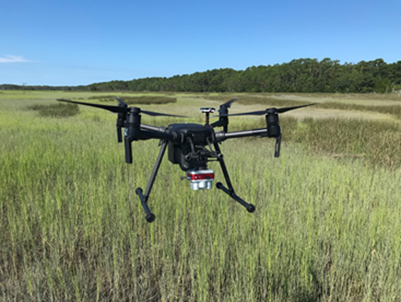
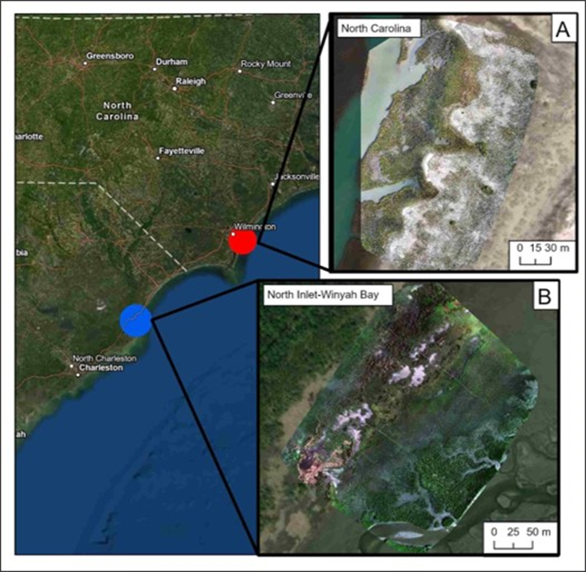
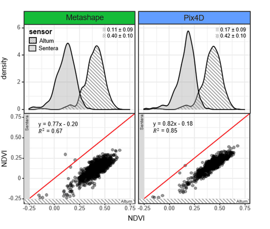
Flights and ground-truthing data were collected by reserve staff at both the North Inlet-Winyah Bay NERR (NIWB) in South Carolina and the North Carolina NERR at Masonboro Island (NC) during September 2020 and February 2021 (Figure 2). Aerial imagery was collected using a DJI Matrice 200 V2 quadcopter equipped with a Micasense Altum sensor at NIWB. In North Carolina, imagery was collected using a DJI Mavic 2 Pro quadcopter with a Sentera Double 4K NDVI + NDRE sensor mounted on the rear of the airframe. In all cases, three flights were conducted on the same day at three different altitudes (25, 50, and 150 m), and imagery sets from all flights were stitched together to create RGB orthomosaics and 3D surface models with both Agisoft (NCCOS) and Pix4D (Duke University).
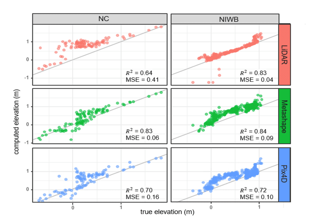
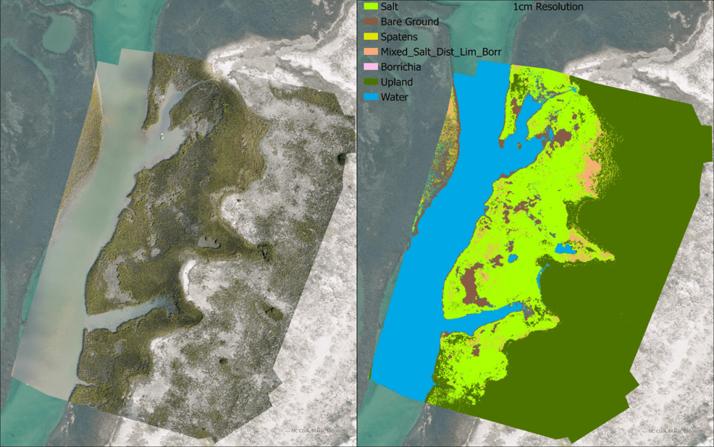
Results to date suggest that UAS-based approaches can add substantial value to wetland monitoring and change detection efforts, potentially allowing the expansion of monitoring activities at lower cost than traditional methods. A comparison of surface elevation models created using UAS-based Structure from Motion (SfM) processing and publicly available Light Detection And Ranging (LiDAR) shows that UAS-SfM performs comparably to LiDAR-based approaches (Figure 3). The high spatial resolution achievable with UAS imagery translates into accurate species-level plant classification (Figure 4) that will be invaluable for quantifying vegetative community distributions with marsh restoration or detecting vegetation shifts associated with climate change. UAS-imagery derived-biomass estimates were well-correlated with on-the-ground approaches, but more work is needed to determine how to use the different types of data generated by different sensors (Figure 5).
When complete, this project will provide a protocol for other wetlands scientists to undertake UAS-based wetland monitoring efforts, and by doing so, will help to facilitate widespread adoption of UAS approaches within NERRS and beyond. UAS based monitoring approaches will result in researchers being better-equipped to detect habitat change at spatial scales that are most relevant to management decisions, and in doing so, will support the NOS/NERRS mission of preserving and managing these critical habitats for the research, education, recreation, and tourism opportunities that they afford.