
ARTICLE AND FIGURES PROVIDED BY STEVE RUBERG (GLERL)
Principle Investigator: Andrea Vander Woude1
Co-Investigator: Steve Ruberg1
Co-Investigator: Lauren Marshall2
Co-Investigator: Eric Anderson1
Co-Investigator: Dennis Donahue1
Co-Investigator: John Sullivan3
Co-Investigator: Zachary Haslick3
1 Great Lakes Environmental Research Lab (GLERL)
2 Cherokee Nation Businesses / Great Lakes Environmental Research Lab
3 Aerodata, Inc.
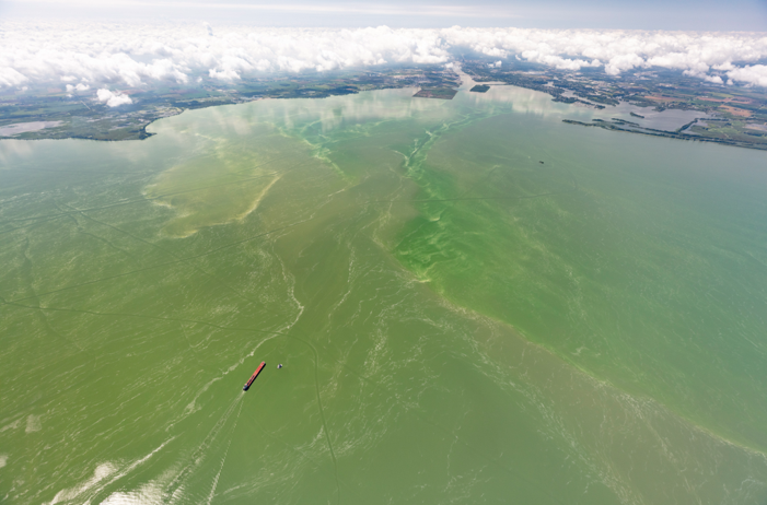
The NOAA Unmanned Aircraft Systems (UAS) Program Office empowers researchers and engineers to use drones to aid in key research projects and quickly respond to weather, climate and other environmental events. Combining powerful UAS platforms and smaller sensors, it is feasible to routinely and rapidly detect events such as oil spills and cyanobacteria harmful algal blooms (cyanoHABs) (Figure 1). Smaller, sophisticated sensors such as hyperspectral cameras are mounted onto UAS platforms to collect high resolution imagery, providing details about water quality. The NOAA Great Lakes Environmental Research Laboratory (NOAA GLERL) is using these technologies to monitor cyanoHABs in the western basin of Lake Erie. A multi-rotor (multi-rotors are UASs that use more than two rotors with fixed-pitch spinning blades that generate lift) UAS will fly beneath the clouds and provide unprecedented imagery of areas close to shore, addressing a key information gap. Typical satellites are only capable of capturing 50-70 cloud-free images in the spring-fall period when HABs are present. More robust datasets that identify the type and location of algal blooms in the nearshore zone near water intake systems will help us continue to advance the models used in the NOAA Lake Erie HAB Forecast.
Why This Work Is Important
The western basin of Lake Erie experiences persistent cyanoHABs during the summer and fall. In August 2014, a cyanoHAB event contaminated the Toledo, OH drinking water supply. Over 400,000 residents were left without drinking water for two days and economic losses were on the order of $65 million (Bingham et al., 2015). In response to the Toledo drinking water shutdown, NOAA GLERL was funded by the Great Lakes Restoration Initiative (GLRI) to operate a weekly airborne hyperspectral imaging campaign. This airborne HAB detection campaign coordinates with the NOAA GLERL and Cooperative Institute for Great Lakes Research (CIGLR) water-quality sampling program to identify toxic blooms in this region. The remote detection of HAB events provides valuable environmental awareness to drinking water managers, improving water treatment responses.
What We Are Doing
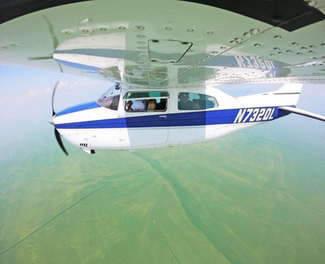
The airborne HAB detection and mapping program at NOAA GLERL includes a hyperspectral camera, the Resonon Pika II, mounted in a contracted single engine Cessna aircraft. The imagery collected during flights is processed using the HAB cyanobacteria index algorithm. Development to separate out potentially toxic and non-toxic phytoplankton taxa through a phytoplankton community composition algorithm is also in progress. A smaller Resonon Pika L sensor purchased in 2017 provides image collection redundancy using the Cessna aircraft (Figure 2). This new system is also designed for use in a UAS. This work is currently funded under the GLRI with flights over Lake Erie and Saginaw Bay on Lake Huron.
Impact of Our Work
Developing UAS capabilities at NOAA GLERL will assist in facilitating a more rapid response to constantly changing Great Lakes cyanoHABs, and will support coastal communities’ efforts to become more resilient to HABs. This project has the potential to allow NOAA GLERL to fill a known gap in real-time mapping of HABs for an operational HAB detection and warning system for Lake Erie water intake managers.
This technology will be transitioned into use demonstrating to water intake managers the accessibility of using a multi-rotor UAS to monitor in close proximity to their intake systems. NOAA GLERL UAS program transitions cost-effective, operationally feasible UAS solutions into routine operations and increases UAS capacity within NOAA.