
ARTICLE, FIGURES AND VIDEO PROVIDED BY: JESSICA CHERRY (NWS/APRFC/AESSIC)
The video below provides a video of highlights early successes with UAS applications by the Alaska-Pacific River Forecast Center (APRFC). The APRFC is funded by the UAS Program to look at the feasibility of using small UAS to map flood inundation, as well as for inspecting towers with meteorological instruments. Alaska’s communities face flood risk from river ice jams, glacial dammed lake outbursts, and rainfall-driven events. So far, UAS show strong potential for helping improve flood forecasts and other decision support products from the National Weather Service.
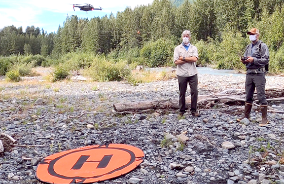
During mid-August in Girdwood, Alaska, members of the Alaska-Pacific River Forecast Center (APRFC) stood in a circle for a safety briefing by Senior Hydrologist and Unmanned Aerial System (UAS) Mission Commander Dr. Jessica Cherry (Figure 1). Flights in Alaska come with unique hazards. “Thanks, everyone for wearing your face masks. Does everybody also have their bear spray?” asked Cherry. All of the locals shook their heads yes, canisters strapped to belt buckles and vest pockets. One forecaster replied, “There was actually a black bear right here when I pulled up.” This got the attention of visiting trainers, CAPT Brian Taggart (NOAA, retired) and CDR Matt Pickett (NOAA, retired), who now run the non-profit Oceans Unmanned out of Idaho and California.
Cherry and the Alaska Region were funded by NOAA’s Unmanned Aerial Systems Program Office to build a UAS project focused on two different applications: flood inundation mapping and inspection of towers with hydro-meteorological instrumentation. “We have a feeling this is just the beginning,” says Cherry, “but these are two very focused missions that can become a part of our operations, immediately.”
Standing up a UAS program at NWS has been non-trivial, even before COVID-19. NOAA’s Office of Marine and Aviation Operations and Aircraft Operations Center (AOC) oversees all of NOAA’s aviation endeavors, but owning aviation resources is a new experience for the NWS Line Office. “After going through the UASPO aircraft procurement process, we learned more about the AOC training requirements and Oceans Unmanned was able to help us navigate that component,” says Cherry. “Unfortunately there are not a lot of official training resources for Commercial, Off-the-Shelf Systems out there, let alone the secure government editions that we are using. Getting an approved COVID-19 action plan in place, getting a green light from NWS Headquarters, and then bringing these guys up to Alaska for training made it possible for us to be successful on our project. Many thanks to everyone—our acting Regional Director, Scott Lindsey, Jim O’Sullivan and Helmut Portmann at HQ and especially Mark Rogers and Nicole Chappelle at AOC–who helped make that happen.”
It helps that five of the NWS Alaska UAS Trainees are already FAA certified airplane pilots. Prior to joining the APRFC in Anchorage, Cherry also ran an airborne research group at the University of Alaska Fairbanks (Figure 2). “I’ve spent a lot of time flying airplanes and doing engineering integrations and payloads. I’m excited to be working with low cost commercial UAS in relatively low risk situations, which still yield beautiful imagery and maps. We’re also doing some cool videography to better understand our river gages, flood impacts, and conditions driven by glacial melt and lake outbursts.”
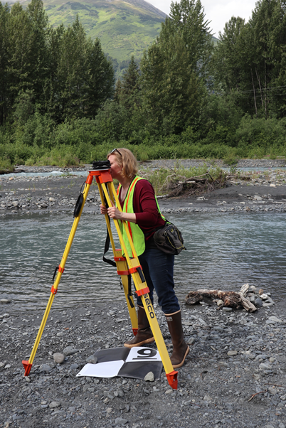
In addition to the four UAS Alaska Region has acquired so far, a differential GPS system has also helped provide ground control for mapping, as well as moving gage sites into common datums used by FEMA and other agencies (Figure 3). Staff members at the APRFC are no strangers to fieldwork, doing their own gage installations and discharge measurements with the WFO-based Service Hydrologists and Electronics Technicians (ETs). Cherry has also engaged members of the Regional IT and ET staff in the UAS training. “These aircraft have the potential to be another great tool in the toolbox for many aspects of NWS operations.”
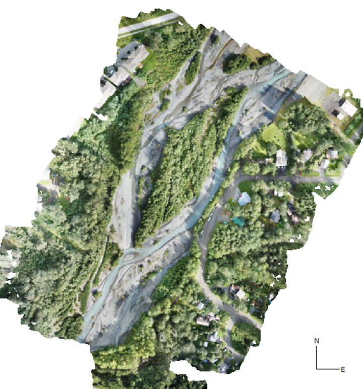
As trainees fanned out across a large gravel bar on Glacier Creek in Girdwood, they took turns flying the UAS, talking on an aviation radio, and learning the DGPS survey system. This mission was a chance to pull together all of the lessons learned over the prior few days in a virtual classroom and an Anchorage city park, applied to a more complex setting near a rural airport. “Glacial melt pushes around a lot of gravel,” said Cherry, “and a heavy rain event can flood this subdivision because of the way this gravel and streambed have migrated over time (Figure 4). We’ve had locals come down to see what we are doing on our UAS missions and they have told me this creek is a real problem for them.” Well, that’s how UAS are helping NWS Alaska protect life, property, and the enhancement of the economy: exactly our agency’s mission.
