Article and Figures Provided By: Dr. Jason Sippel (AOML/HRD)
For over 30 years, NOAA has utilized reconnaissance aircraft to obtain measurements within tropical cyclones (TCs), including hurricanes in the Atlantic and Gulf of Mexico. These platforms have proven extremely valuable for furthering TC research and improving forecasts. Any data that improves tropical cyclone forecasts in turn improves tropical cyclone watches, warnings, and relevant evacuation information.
The recent advent of small Uncrewed Aircraft Systems (sUAS) are being evaluated for their potential to enhance the reconnaissance data gathered by NOAA by operating in hazardous regions where conventional aircraft cannot fly. sUAS provide a variety of atmospheric measurements with greater flexibility than conventional aircraft at a relatively small cost. One such sUAS, which has been deployed and controlled from the NOAA WP-3D (P-3), aircraft is the Coyote. The Coyote, first deployed during flights into Hurricane Edouard (2014), is capable of remaining airborne for up to one hour to provide high-resolution pressure, temperature, humidity, and wind observations. Since the initial flights, a total of seven successful Coyote missions were flown in 2017 and 2018, including six over a series of three NOAA P-3 flights into Hurricane Maria (2017). The Coyote flights were generally focused on the hurricane center, sampling both the eye and eyewall.
More recently, a study supported by the Uncrewed Systems Research Transition Office (UxSRTO) with funding from the NOAA Office of Marine and Aviation Operations (OMAO) resulted in the first-ever attempt to assimilate sUAS observations into a NOAA operational forecast model. Coyote sUAS observations were assimilated into the operational Hurricane Weather and Research Forecasting (HWRF) model in a series of experiments intended to guide future efforts to assimilate sUAS observations operationally. An experiment with Coyote sUAS observations assimilated into HWRF generally produced superior analyses and forecasts as compared to an experiment that assimilated no Coyote data (Figure 1). In particular, the track forecast improved by up to 20% (left), and the forecast of minimum pressure (a measure of intensity) improved by over 20% (right) for a sample of forecasts in Maria. One of the key findings from that analysis to consider for future sUAS data assimilation efforts is that more improvement to forecasts resulted when observations were symmetrically distributed around the storm center.
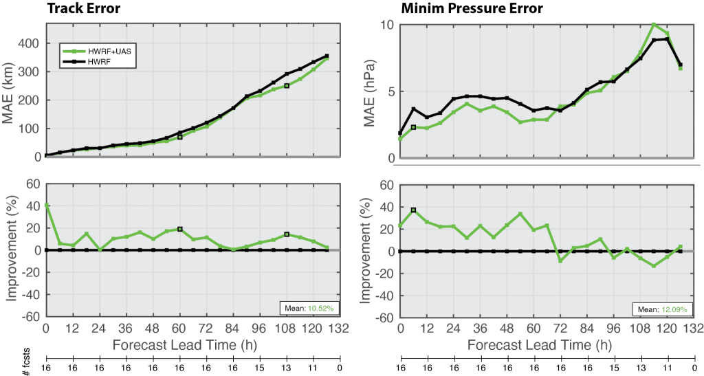
A caveat of this work is that the sample size is very small. Coyote data was only assimilated for three individual forecasts, and forecast error statistics were evaluated over 16 forecasts. This is far too small of a sample to make clear conclusions, and many more similar sUAS flights are needed for a more robust assessment of forecast impact.
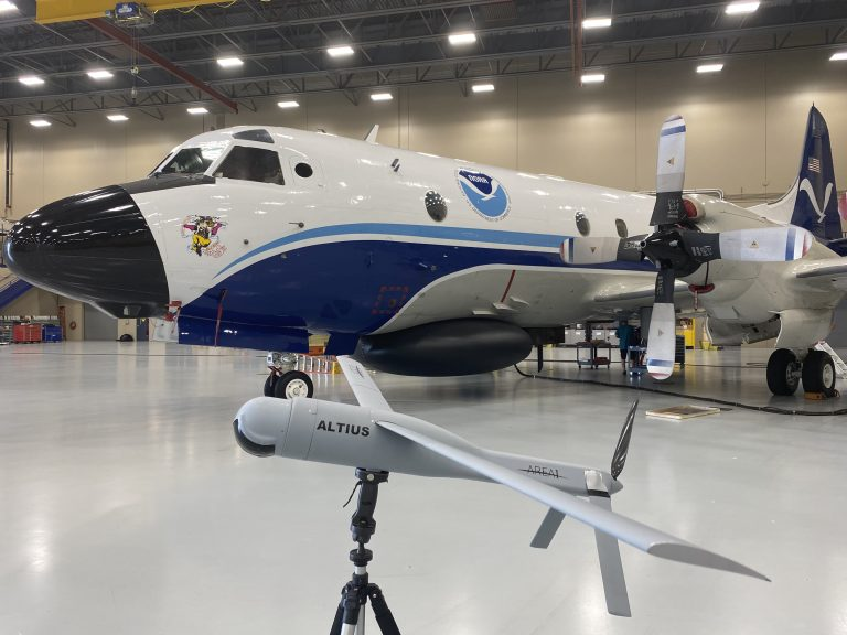
Fortunately, even more recent innovation has resulted in the development of new and improved sUAS platforms, such as the Altius-600 (Figure 2). With the Altius, scientists from NOAA’s Atlantic Oceanographic and Meteorological Laboratory (AOML) completed a successful milestone demonstration in Hurricane Ian on September 28, 2022, while onboard a NOAA WP-3D Orion Hurricane Hunter aircraft (N42RF, “Kermit”). Since then, other NOAA scientists have already begun examining the data obtained from that historic deployment, and they look forward to additional demonstrations in the future with a goal toward transitioning such capabilities into routine operations and, potentially, substantially improved TC forecasts.