

Article and Figure Provided by: Rick Stumpf (NOS)
Why We Care
Several algal blooms around the U.S. produce biotoxins that pose significant risks to human health and marine life. In recent years, these harmful algal blooms (HABs) have caused unprecedented impacts on coastal communities and the tourism, recreation and fishing businesses that support them. In Florida, for example, a recent (2017-2018) “red tide” lasted more than a year and ultimately impacted most of the Florida coast line, creating devastating impacts for fishermen, tourism, and local (beachside) businesses.
In 2004, the National Ocean Service, through the National Centers for Coastal Ocean Science (NCCOS) and the Center for Operational Oceanographic Products and Services (CO-OPS) implemented an operational forecast system for Karenia brevis blooms (red tides) in the Gulf of Mexico and eastern Florida. Karenia brevis is unusual in that its toxin frequently ends up in aerosols coming off the water, which causes respiratory irritation or health risks. This forecast aids state managers and the public by incorporating satellite imagery with state-led water sampling programs to identify the locations of the HABs and the risk they pose of respiratory risk. This capability is able to provide county-level resolution every few days. However, the blooms are frequently so patchy that beaches only a half mile apart may have quite different HAB concentrations on the same day, and thus experience very different health risks. In fact, forecasts of respiratory impact somewhere in a county are right 70-80% of the time, but accurate for individual beaches only 20% of the time (Stumpf et al., 2009). As a result of the lack of forecast resolution, when a red tide occurs, it is perceived as being a constant problem everywhere.
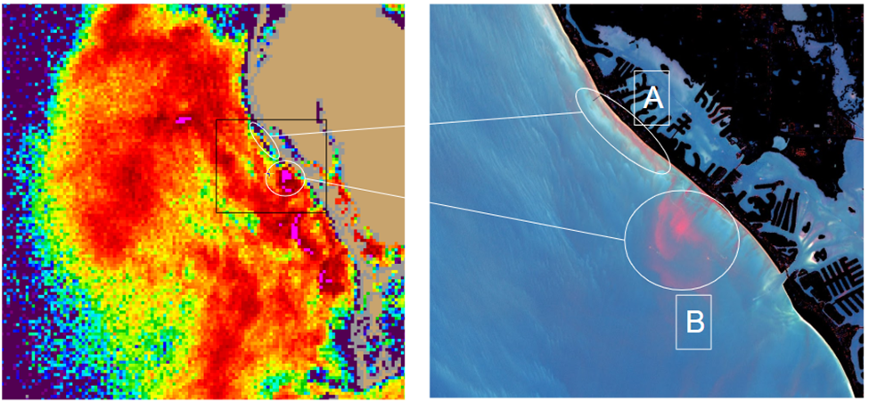
Coastal states typically sample and monitor for HABs weekly. Satellites can retrieve daily data. However, cloud cover is a distinct limitation and the low (nominally 300 m to 1 km) resolution satellite data cannot resolve where the blooms are within 300 to 500 m of the coast, where the impact is most severe (Figure 1). Consequently, specific and frequent information on individual beaches is not available to aid in the forecasts of the risk of respiratory irritation.
What We Are Doing
The goal of this project is to solve this resolution problem. Using sUAS (small Unmanned Aircraft Systems) deployed with HAB sensors, we are working to develop and demonstrate a rapid, cost-effective response capability in order to more quickly and accurately know the location of bloom patches. Advancing this real-time detection capability would enable states (especially Florida) and counties to more effectively deploy and focus their limited sampling resources. Furthermore, this capability would enhance NOAA’s HAB forecasting capability to be able to provide improved warnings to the public, and therein increase public safety and reduce economic impact. This capability, once demonstrated, can be applied to several other HABs, and will be transitioned to states for integration into their HAB monitoring programs.
Sunlight causes these blooms to fluoresce at a specific wavelength of red light. A custom Solar Induced Fluorescence optical sensor will be developed to capture, digitize, store, and relay in real time, five optical bands to look at fluorescence in the water, and one channel to capture how much sunlight was coming down (down-welling irradiance) in order to correct for clouds. A dedicated digital microwave link will be included to relay the real time data back to the UAS operator where it can then be forwarded to a central repository for real time monitoring.
The developed instrument will be composed of a lightweight sensor, data system, and microwave link mounted to one of targeted sUAS platforms, and a companion dedicated Controller Display Unit (CDU) located on the ground with the operator. The CDU will enable the operator to control the sensor, display the HAB concentration on a map, and relay the results in real time via 4G/5G network to a central NCCOS server where it can be further processed, analyzed, and used to generate HAB alerts, etc. The payload system is designed for real-time assessment, but with data download for additional analysis and research.
To our knowledge, there is currently no alternative operational system that implements this approach.
Impact/Benefits of Our Work
Improved HAB forecasting is identified as an agency priority in the NOAA Next Generation Strategic Plan. The anticipated impact of our proposed work using sUAS technology, compared to current observing platforms, is the ability to rapidly deploy, image, and detect potential blooms, in real-time, with a sUAS sensor package. In addition, the approach is intended to target the near-shore environment, which is beyond the detection capability of current satellite-based HAB monitoring and forecasting abilities. Furthermore, the proposed approach is intended to be more responsive, timely, and cost-effective than current sUAS hyperspectral or multispectral imaging techniques that have their own radiometric calibration issues, and considerable post-processing lags. HAB events are spatially and temporally episodic, which requires a real-time detection and operational responsive capability not met by current technologies or approaches, but what this work explicitly addresses.
Advancing this real-time detection capability would enable states (especially Florida) and counties to more effectively deploy and focus their limited sampling resources. Furthermore, this capability would enhance NOAA’s HAB forecasting capability so as to be able to provide improved warnings to the public, and therein increase public safety and reduce economic impact. This capability, once demonstrated, will be transitioned to states for integration into their HAB monitoring programs. This research in part is made possible with funding from the NOAA UAS Program to accelerate transition of UAS research to operations.