
Article and Figures Provided By: Lee R. Harrison (SWFSC)
Duration: 27 months (June 2017 – September 2019)
Principal Investigator: Lee R. Harrison1
Co-Investigators: Mike Aslaksen2, Miles E. Daniels1, Eric Danner1, Peter N. Dudley1, Carl J. Legleiter3, and Jason Woolard2
1Southwest Fisheries Science Center (SWFSC), NMFS, NOAA, Santa Cruz, CA, 2Remote Sensing Division, NOAA’s National Geodetic Survey, Silver Springs, MD, 3USGS Integrated Modeling and Prediction Division, Golden, CO
River systems provide the physical template for aquatic organisms, including endangered salmonids, and characterizing riverine habitat structure is crucial for species management and conservation. Traditionally, salmon habitat data has been collected over short river segments using ground survey methods, but there is a need to characterize habitat in high resolution at larger spatial scales. Advances in remote sensing from manned aircraft have greatly improved the ability for habitat mapping at larger scales but these approaches may not capture fine-scale habitat features. Now scientists at NOAA and the USGS are working to determine if imagery collected from unmanned aircraft systems (UAS) can be used to help provide quantitative habitat data at ecologically-relevant scales (Figure 1).

In the first phase of a two-year UAS Program Office-funded project, scientists tested a new UAS observation system (Figure 2) to see how well it could map the bathymetry (i.e. water depth) of the Sacramento River, located in California’s Central Valley. The Sacramento is the state’s largest river, and is a vital source of water for urban and agricultural uses and supports three populations of Pacific salmon listed under the Endangered Species Act (ESA). The research team evaluated the potential to map river bathymetry using UAS-based hyperspectral imagery, and compared the results to conventional remote sensing techniques, including hyperspectral imagery and bathymetric LiDAR data acquired from a manned aircraft and WorldView-3 satellite imagery. The results from this study were published in the journal Water Resources Research (Legleiter & Harrison, 2019), and demonstrated for the first time that UAS-based hyperspectral imagery could be used to effectively map river bathymetry on a large river, with comparable accuracies to conventional remote sensing techniques. The methods developed in this project are transferable to other river systems where bathymetric data is needed; for example, in the development of predictive, hydrodynamic models or in habitat surveys where fine-resolution bathymetric data is required.

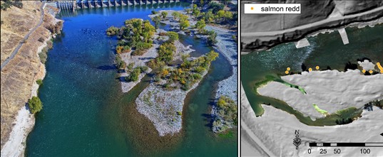
In the second phase of this project, scientists evaluated the potential of using UAS to identify the location of salmon spawning nests (referred to as redds), along the American River, which is a major tributary to the Sacramento River. Loss of spawning habitat has been cited as a key contributor to salmon population declines and knowledge of spawning sites is crucial for population recovery and river restoration. Salmon redds traditionally have been identified through direct ground surveys over short river reaches or mapped visually from aerial imagery obtained from manned aircraft or helicopters. Here, the research team developed a novel, semi-automated workflow for detecting salmon redds by applying machine learning techniques to UAS-based imagery. Scientists acquired UAS-based true color (RGB) and hyperspectral imagery during the period when spawning fish were constructing redds. In addition, the redd mapping performance of two classification algorithms was tested. Results from this study found that the best results were obtained using hyperspectral imagery and a support vector machine (SVM) algorithm, which could correctly predict redd locations with accuracies greater than 90%. This study highlights the potential of UAS-based approaches for mapping salmon spawning sites and provides improved tools which can be used in salmon population monitoring and recovery efforts.
Citation
Legleiter, C. J., & Harrison, L. R. (2019). Remote Sensing of River Bathymetry: Evaluating a Range of Sensors, Platforms, and Algorithms on the Upper Sacramento River, California, USA. Water Resources Research, 55(3), 2142-2169. doi:10.1029/2018wr023586.