The OAR ORTA UxSRTO is no longer operating.
For further information, please visit The Office of Marine and Aviation Operations (OMAO) Uncrewed Systems Program webpage.


Address critical data gaps
Facilitate UxSRTO application
Evaluate ship-launched UxSRTO technology and infrastructure
Develop extended visual line of site operations
Analyze the value of high-altitude observations
Develop UxSRTO CONOPS for conducting pinniped survets in remote regions
Accelerate transition of UxSRTO capabilities from research to operations
Provide expertise and resources for UxSRTO research and development
Uncrewed Systems Research Transition Office
What We Do
Uncrewed Systems Research Transition Office (UxSRTO) can revolutionize NOAA’s ability to monitor and understand the global environment. There is a key information gap today between instruments on Earth’s surface and on satellites – UxSRTO can bridge that gap. Operated by remote pilots and ranging in wingspan from less than six feet to more than 115 feet, UxSRTO can also collect data from dangerous or remote areas, such as the poles, oceans, wildlands, volcanic islands, and wildfires. Better data and observations improve understanding and forecasts, save lives, property, and resources, advancing NOAA’s mission goals.
Operated remotely, UxSRTO can collect critical observations from dangerous or remote areas, such as the poles, oceans, wildlands, storm damaged areas, volcanic islands, and wildfires. Demonstrating extraordinary capabilities for acquiring data in such challenging environments, matured UxSRTO technologies provide a transformative capacity to enable NOAA’s scientists to better perform their missions. UxSRTO advances NOAA’s goals of preserving lives, property, and environmental resources by enhancing scientific understanding, increasing forecast accuracy, and providing safer, more efficient earth and wildlife observations.
NOAA’s Alaska Fisheries Science Center’s (AFSC) studies Alaska’s marine ecosystems to ensure the sustainable use and conservation of living marine resources in federal waters. A recent study done by NOAA scientists focuses on surveying ice seals, with the primary goal of deploying non-invasive, low-disturbance methods for monitoring the body condition of Arctic seals as an indicator of population health and productivity. During April 2022, researchers with the The Polar Ecosystems Program (PEP) embarked on the NOAA AFSC ice seal research expedition aboard the NOAA Ship Oscar Dyson in the eastern Bering Sea. (Video/Credit: AFSC). Read more in our article, click here.
Check Out Our Newest Videos
Check Out the Highlights of UxSRTO
The UxS Research Transition Office (UxSRTO) is helping NOAA realize the potential these systems offer by supporting innovative research and development (R&D) of UxS technologies across NOAA’s broad mission space.
Current HighlightsWhat's Happening In the News


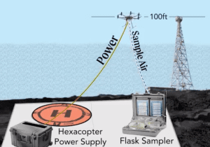
NOAA Global Monitoring Laboratory Development of a UAS “Virtual Tower” for Gas and Ozone Measurements
Scientists from NOAA’s Global Monitoring Laboratory (GML) have undertaken novel development of an uncrewed aircraft system (UAS) “hexacopter” that will enable the lab to not only recommence a long-standing mission that was recently forced to halt, but paves the way toward enhanced operations in the future. The composition of Earth’s atmosphere is rapidly changing due to anthropogenic releases of carbon dioxide (CO2) and methane (CH4), which are powerful greenhouse gasses driving global warming. Also, human-made chemicals such as CFC-11 and CFC-12 (refrigerants) are destroying the ozone layer that filters out ultraviolet (UV) radiation. These CFCs and their counterparts destroy enough of the protective stratospheric ozone layer to produce the Antarctic “Ozone Hole”.


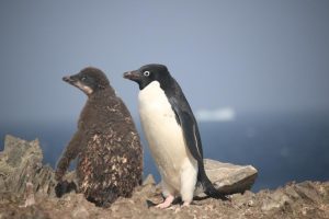
First Beyond Visual Line of Sight (BVLOS) UAS Mission to Map and Count Penguins in Antarctica
A key mission of the Antarctic Ecosystem Research Division (AERD) at NOAA Fisheries’ Southwest Fisheries Science Center (SWFSC) is to develop an understanding of how an international krill fishery operating in Antarctic waters may impact other Antarctic wildlife that consume the main target of this fishery: Antarctic krill (Euphausia superba). Three species of brush-tailed penguins (Pygocelis spp.) nesting in the South Shetland Islands off the Antarctic Peninsula primarily or exclusively consume Antarctic krill. Over the last three decades AERD scientists have monitored the number of penguin chicks raised each year by Adelie (Pygocelis adeliae), Gentoo (Pygocelis papua), and Chinstrap (Pygocelis antarcticus) penguin as one important indicator of how these populations are responding to natural variability and to the impacts of the krill fishery.
During this project Dr. Trevor Joyce, a contractor affiliated with the SWFSC’s Marine Mammal and Turtle Division, and Dr. Jefferson Hinke from AERD flew a series of Uncrewed Aerial Systems (UAS) missions at AERD’s Copacabana Field Camp on King George Island, Antarctica (62.178°S, 58.446°W) using the FireFly6 Pro fixed-wing vertical take-off and landing (VTOL) UAS. The purpose of these flights was to collect very high-resolution aerial images (0.7-1.2 cm ground sampling resolution) of the penguin colonies in order to count the number of penguin chicks produced in the current breeding season.


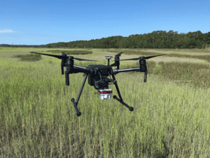
NOAA and Duke University Examine UAS-based Approaches for Coastal Wetland Monitoring
Project team: NOAA National Centers for Coastal Ocean Science (NCCOS), Duke University Marine Robotics Laboratory and Remote Sensing Laboratory, North Carolina National Estuarine Research Reserve (NERR) and North Inlet-Winyah Bay NERR.
The core mission of NOAA’s National Ocean Service (NOS) includes stewardship of sensitive coastal habitats like those of the National Estuarine Research Reserve System (NERRS), a collection of 29 sites nationwide where NOS and States partner to promote research, education, and preservation of estuarine ecosystems. Unmanned Aerial Systems (UAS) can improve tidal wetland monitoring by providing high spatial resolution and coverage, with customizable sensors, at user-defined times.
This NOS National Centers for Coastal Ocean Science (NCCOS) research project, supported by the NOAA Uncrewed Systems Research Transition Office (UxSRTO), develops methods for the incorporation of Uncrewed Aircraft Systems (UAS) to expand routine wetland monitoring programs like those conducted by the National Estuarine Research Reserve System (NERRS).
