
Article and Figures Provided By: Melissa Wagner (NSSL/CIMM)
Principal Investigator: Mike Coniglio1
Co-Investigator: Erik Rasmussen1,2
Co-Investigator: Melissa Wagner1,2
1 National Severe Storms Laboratory (NSSL)
2 Cooperative Institute for Mesoscale Meteorology
Damage assessments provide insight into the occurrence, intensity, and distribution of tornadoes and other high-wind events. Current ground survey and satellite assessments, however, are restricted by available resources (e.g., personnel, time, and cost), accessibility, technological limitations, and damage indicators used to infer storm intensity. These assessments can be especially challenging in rural areas because storm damage is frequently underestimated due to the inability to detect vegetation stress, limited vegetation damage indicators, and low population density. In these sparsely populated areas, storm damage is often underreported and consequently affects severe storm climatology and our understanding of risk. Underestimating this risk can have serious implications on hazard monitoring as well as disaster preparedness and recovery in rural areas. With the help of the NOAA Oceanic and Atmospheric Research (OAR) Uncrewed Systems Research Transition Office (USRTO), scientists from the NOAA National Severe Storms Laboratory in collaboration with the Cooperative Institute for Mesoscale Meteorological Studies are working on developing an uncrewed aircraft system (UAS)-based approach to better characterize high-wind damage to vegetation and in rural areas to improve disaster response and recovery.

The objectives of this project are to:
- Better characterize high-wind damage to vegetation and in rural areas using a system that integrates UASs, multispectral imagery, and geospatial methods,
- Correlate storm processes to UAS-based damage information and radar data (e.g., WSR-88D),
- Rapidly distribute damage information to improve disaster response and recovery.
The very high resolution imagery collected by the UAS allows for centimeter scale resolution, which can capture information that is frequently missed with current traditional approaches. Combining this information with meteorological observational datasets will lead to a better understanding of the relationship of identifiable storm structures and storm hazards and may lead to new discoveries in local extreme wind production phenomena. This is particularly important in the Southeast US where storm mechanisms involved in tornadogenesis remain poorly understood.
This work has the potential to improve severe weather forecasts and warnings through better documentation of severe weather events and better assignment of damage ratings in sparsely populated rural locations. This detailed UAS information will likely improve the accuracy of severe storm report database and tornado climatology. Additionally, more accurate damage information will also improve disaster loss estimates for FEMA, insurance agencies, and the affected public.
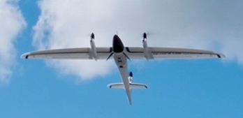
This research will continue into next spring, with a plan to work with local National Weather Service Forecast Offices (NWS WFOs) and local emergency managers to map disaster affected areas in the Southeast United States. Scientists will deploy a Quantum Trinity F90+ (fixed wing with vertical take-off and landing capabilities (VTOL)) equipped with a visible (Sony UMC – R10C) and multispectral camera (Micasense RedEdge-MX) to collect visible and multispectral imagery, respectively. The Trinity F90+ is able to map a significantly larger area (e.g., 700 hectares/3.2 cm/px at 120 m AGL) compared to multirotor copters due to the longer flight time (battery life of up to 90 minutes) and technology (motors) (Figure 2). The UAS-based high-wind damage imagery would be processed using a cloud-based computing solution and shared in the form of maps with local NWS WFOs and emergency managers. From this information, NWS WFOs and local emergency managers would better understand the extent and magnitude of high-wind damage in a shorter time frame and could help improve disaster response operations, management, and recovery.
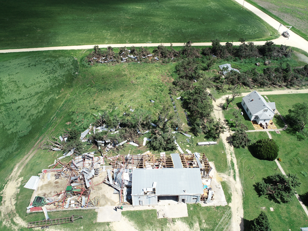
Storm damage assessments utilizing UAS-based platforms can allow for better access in remote areas that are difficult to reach or obstructed by damage. These systems can be deployed almost immediately after a storm, (allowing for capture of perishable data prior to extensive clean-up), and are able to capture the high-resolution imagery needed for a more complete damage assessment, (assigning intensity ratings for tornadoes based on the Enhanced Fujita (EF)-scale, for instance, and distinguishing between tornadic and straight-line winds). The Enhanced Fujita (EF) scale rates the intensity of tornadoes, based on the damage they cause.
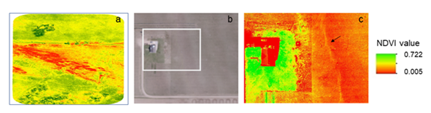
UAS-based multispectral imagery can better detect damage to vegetation, especially low-level EF-scale damage, because of the centimeter scale information and spectral response of vegetation in the red, red-edge, and near-infrared bands. Vegetation health assessments often use the near-infrared band, because of its ability to detect vegetative stress not visible to the human eye. For example, UAS-based multispectral imagery can differentiate high-wind impacts (e.g., erosion, scour, soil and hay deposition) shown in Figure 3a as well as detect larger portions of vegetation damage not discernable in visible imagery, even in areas of low vegetation (see Figure 3b and 3c). This detailed documentation of high-wind damage can lead to a better understanding on how vegetation is affected by tornadic and non-tornadic winds, enabling the development of more damage indicators for vegetative cover and in rural locations. Combining UAS-based multispectral imagery with meteorological observations and/or radar data can lead to a better understanding of the mechanisms involved in tornadogenesis and quasi-linear convective systems, or linearly-oriented zone of convection.
In addition, it is important to recognize ongoing efforts in utilizing UASs for NWS WFOs damage surveys. In particular, the NWS Eastern Region Drone Team (ERDT) has been investigating the role of UAS technologies to support NWS storm damage surveys and rapid response operations since 2015. In 2016, the NWS Blacksburg, VA Weather Forecast Office (WFO) was able to identify the beginning and ending points of the 24 February 2016 EF3 Appomattox, VA tornado, adding four additional miles to the tornado track beyond what was captured during ground-based surveys with the help of Autonomous Flight Technologies. Currently, the ERDT are using multi-rotor copters (3DR solos) for their UAS-based damage surveys as well as working with academic institutions (Virginia Tech) to improve damage detection in forested areas. Similar efforts are underway in NWS Paducah, KY WFO. Other NWS WFOs, such as Norman, OK, have been able to augment their damage surveys with UAS imagery supplied from academic partners, commercial companies, and other government agencies. This detailed information can better distinguish storm type based of high-wind damage patterns as well as identify different wind-flow characteristics within the damage path as demonstrated by Skow and Cogil (2017).
This shows the importance and societal benefits of utilizing UAS to help characterize of high wind damage to vegetation and provide rural area assessments to improve disaster response and recovery.
Reference: Skow, K. D., and C.Cogil, 2017: High-Resolution aerial survey and radar analysis of quasi-linear convective system surface vortex damage paths from 31 August 2014. Wea. Forecasting, 32, 441–467, https://doi.org/10.1175/WAF-D-16-0136.1.