
Article Provided By: Robert Moorhead (Director, NGI) and John Walker (Contract Support For USRTO). Photos Provided By: Robert Moorhead (Director, NGI)
The NOAA OAR UAS Program, in cooperation with the National Weather Service River Forecast Centers (NWS RFCs) in the Southern Region and the Northern Gulf Institute (NGI; a NOAA Cooperative Institute), established a study several years ago to determine the cost and contributions of UAS-collected data toward improving forecasts and warnings of significant flood events. While the impacts of severe flooding are not isolated to this area alone, according to NOAA NCEI’s 2020 report, U.S. Billion-Dollar Weather and Climate Disasters, “The highest frequency of inland flood (i.e., non-tropical) events often occur in states adjacent to large rivers or the Gulf of Mexico, which is a warm source of moisture to fuel rainstorms”. The need for accurate, rapidly obtainable data in this region is all the more emphasized when this fact is combined with other known impacts from land-falling tropical cyclones each hurricane season.
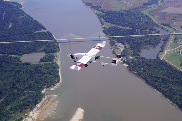
In October 2020, NGI added to the list of previous successful UAS deployments in support of this study, as the group was once again called into action by the regional NWS RFC to collect aerial flood image data after Hurricane Delta made landfall in Louisiana and passed through Mississippi. With operations based along the Mississippi River near Greenville, Mississippi, NGI collaborated with the Raspet Flight Research Laboratory (RFRL) at Mississippi State University to deploy a TigerShark XP3 (Figure 1). This large, Group 3 UAS platform, which boasts a 21-foot wingspan and a nominal weight of around 500 pounds, was flown for several hours over long stretches of flood-inundated land to collect imagery on both sides of the river. Collected data was then transmitted to awaiting end users at the NWS Lower Mississippi RFC where it was used to support and enhance their existing operations.

While residual clouds persisted for several hours, inhibiting mission initiation at the beginning of the operational window, the team was finally able to launch and successfully collect the targeted data. Nevertheless, the research team is also working hard to ensure that such delays and potential mission cancellations soon become a thing of the past. Although the FAA presently requires operations be conducted under visible flight rules, the NOAA OAR UAS Program initiated a concurrent effort with NGI and RFRL in 2019 to identify safe, effective measures to enable Beyond Visible Line of Sight (BVLOS) operations. Once NGI and RFRL obtain enough flight data to support an adequate safety case, the goal is to request permission from the FAA, allowing the group to operate UAS launches and landing through the clouds. This, in itself, would represent yet another significant milestone in the overall effort, as it would enable quicker post-storm response, eliminate the need for visual observers, and greatly reduce the cost of operations.
Cited References:
NOAA National Centers for Environmental Information (NCEI) U.S. Billion-Dollar Weather and Climate Disasters (2020). https://www.ncdc.noaa.gov/billions/, DOI: 10.25921/stkw-7w73.
Another One in the Books… NOAA UAS Science Team Completes Second Milestone Operation to Aid Hydrologists with Improving Flood Forecasts (2019). https://uas.noaa.gov/News/Articles/ArtMID/6699/ArticleID/812/Another-One-in-the-Books-NOAA-UAS-Science-Team-Completes-Second-Milestone-Operation-to-Aid-Hydrologists-with-Improving-Flood-Forecasts.