
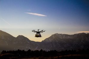
High Accuracy Trace Gas Measurements from a Lightweight UAV
Recently, numerous studies have contested the global impact of fugitive emissions from oil and gas operations on the methane budget. Consequently, precise quantification of gas leaks is needed to better constrain the total methane burden from this source. In the past, high precision insitu analyzers mounted in a research aircraft have been used to circle the suspected leak and quantify the plume. While this is a robust method, it is costly, and missions cannot be deployed quickly. Quick deployment is needed because leaks can be transient, variable, and a huge safety hazard. A lightweight UAV is uniquely suited to both fly through a plume generated by a leak, and deploy quickly at little cost. However, the UAV platform is too small to carry the 70-pound analysis system used on a plane.
NOAA GMD has developed a unique sampling system, called the Active AirCore, in which a pump compresses air into a 100-meter long, small diameter tube at a constant flow rate. This long tube acts as an “atmospheric tape recorder” by storing the sample stream in the long tube. When the sample is analyzed, the data is a “play back” of the air the UAV flew through while in flight. The sampler can be removed from the UAV, and immediately analyzed using an ultra-high precision trace gas analyzer like those used on aircraft. This new sampling system provides the same level of accuracy as an analyzer mounted on a larger aircraft, but is light enough to be flown on a UAV. Because the measurements are done in a van at the flight location, data analysis and quantification of the leak is near-real time. This near-real-time analysis allows highly flammable natural gas leaks to be quickly identified and quantified providing information that will help evaluate the safety and potential economic losses at an individual oil and gas production site.
Development of an Autonomous Payload for Detection of Seals and Polar Bears on Sea Ice
Polar bears and Ice-associated seals (bearded, ringed, spotted, and ribbon seals) are key components of Arctic marine ecosystems and are important resources for coastal Alaska Native communities. Reliable abundance estimates for ice seals are needed for developing sound management decisions under the Marine Mammal Protection Act and extinction risk assessments under the Endangered Species Act. The animals’ broad and patchy geographic distributions and rapidly changing sea ice habitat make these species particularly challenging to study.
An autonomous payload is required to integrate UAS into surveys of ice-associated mammals, in order to improve the efficiency and human safety in gathering essential data for NOAA stewardship. Moving from occupied aircraft to long-range UAS operations will require an efficient and “smart” payload to collect images needed for abundance estimation and habitat analysis while providing situational awareness to the pilot in command.
The Alaska Fisheries Science Center’s Marine Mammal Lab is developing a system that can run advanced machine learning algorithms on-board the aircraft to process multispectral imagery in real time, minimizing the collection of extraneous imagery that requires burdensome data storage, management, and processing. Algorithm development is utilizing a neural network approach known as YOLO, which processes imagery at a rate of 60-100 frames per second. Over 1.8 million color and thermal images are being used to train YOLO to detect animals on the sea ice and classify detections to species. This algorithm will be tested in-flight during April 2019.
Nighttime Fire Observations eXperiment (NightFOX)
Biomass burning produces major impacts on local and regional air quality which potentially plays an interactive role in climate change. A capable small, fixed-wing unmanned aircraft system (sUAS) can serve as an ideal platform for measurements of biomass burning emissions, plume distribution, fire extent and perimeter, and supporting meteorological data, especially at night when manned aircraft typically do not operate. The NOAA UASPO-funded Nighttime Fire Observations eXperiment (NightFOX) project aims to develop and deploy a sUAS observation system utilizing two modular and easily exchangeable payloads. One payload will provide in situ measurements of CO2, CO and fine- and coarse-mode aerosol size distributions in biomass burning plumes for characterization of fire combustion efficiency and emissions. A filter sampler will collect bulk aerosol samples for off-line composition analysis. The second payload will be flown over the fire to make remote sensing measurements of fire perimeter and fire radiative power using visible and short-, mid-, and long-wavelength IR observations. The multi-spectral remote sensing data will be used to provide sub-pixel information for comparison with satellite fire observations, and along with measured meteorological parameters, will be used to inform, test, and improve the WRF-SFIRE fire-atmosphere model.
Prototype in-situ and remote-sensing instrument payloads have been developed and are operational. Initial test flights with the payloads have recently been conducted. The performance of the prototype payloads has proven satisfactory and new versions are currently under development that will be used for the NIghtFOX operational deployment to study western wildfires next summer during the NOAA/NASA FIREX-AQ mission. Preliminary data processing algorithms for the remote sensing observations have been developed based on test flight results. A nighttime high-altitude FAA COA was obtained and a nighttime flight to an altitude of 2000 ft (0.61 km) was conducted on November 08, 2018, as a stepping stone to the 1 km design altitude for remote sensing operations.
NOAA Evaluates Using Drones for Lidar and Imagery in the National Estuarine Research
Office for Coastal Management (OCM) scientists and their partners tested the utility of private sector drone technology to map marsh habitat in three estuarine research reserves. The team evaluated the quantitative spatial accuracy of both imagery and lidar products, as well as the qualitative gains for habitat mapping in multiple ecosystems.
Obtaining good solid earth elevation data is particularly difficult in dense marsh areas where it is also a critical component to understanding marsh vulnerability to sea level rise. The potential of lidar drone technology to penetrate to the ground with a smaller laser footprint and higher point density could provide a product that is currently unattainable from manned aircraft. Similarly, the detail in imagery that drone technology offers has the potential to provide finer delineations of habitat than the reserves have had from manned imagery. Contract spatial accuracy specifications were set at 10 cm root mean square error (RMSE) vertically for the lidar data and 15 cm RMSE horizontally for the imagery.
During the mission, Quantum Spatial and PrecisionHawk operated the drones, collected the data, and processed it. Staff from OCM and the three reserves (Jacques Cousteau, Grand Bay, and San Francisco Bay) collected independent ground-truth validation data and evaluated the drone deliverables. The two square mile area in San Francisco Bay reserve generated over 380,000 images and had lidar point density of over 400 points per square meter.
The two-year project (Fiscal Years 2016-2018) was funded by NOAA’s Office of Oceanic and Atmospheric Research. The project team includes partners from OCM, Jacque Cousteau NERR, Grand Bay NERR, San Francisco Bay NERR, Wells NERR, Quantum Spatial, and PrecisionHawk.
Advanced UAS Sensor Development for Marine Mammal Monitoring
In 1963, NOAA Fisheries’ Marine Mammal Laboratory (MML) began to use the mark-recapture method of shear-sampling northern fur seal pups to estimate pup abundance. Presently, these surveys are conducted every two years on St. Paul and St. George Island (Pribilof Islands, Alaska). These trips require up to 22 people to be stationed on the islands for up to three weeks and the presence of scientists on the rookery creates disturbance (authorized by a Federal permits: NMFS/MMPA 14327 and IACUC ANW2013-3). With the help of the UAS Program Office, MML has been collaborating with NOAA’s Aircraft Operations Center (AOC), National Environmental Satellite Data and Information Service (NESDIS), Mystic Aquarium, Aerial Imaging Solutions, and GeoThinkTank (Figure 1) to work on developing a UAS-based approach for conducting northern fur seal abundance surveys.
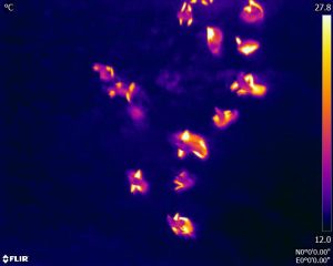
MML has successfully implemented unoccupied aircraft systems (UAS; i.e., drones) to supplement annual Steller sea lion abundance surveys since 2014. Given the size and relatively more distinct coloration from their background, using a high-resolution mirrorless camera has worked well for capturing images of Steller sea lions (Figure 2). The challenge with developing a similar approach for northern fur seals has been deciphering small black fur seal pups from the black boulder substrate common in the Pribilof Islands—northern fur seals are much harder to count in images!
We have a few objectives for our project to get us closer to our goal: (1) assess a heavy-lift hexacopter with longer flight times and ability to carry heavier payloads, (2) evaluate imaging capabilities of a thermal sensor for northern fur seals, and (3) conduct an on-the-ground assessment of the feasibility of multi-spectral imaging for distinguishing northern fur seals from their background.
In August of 2018 during the shear-sampling surveys on St. George Island, we were able to test the APH-28 hexacopter (Figure 3) (Aerial Imaging Solutions) mounted with the FLIR DUO Pro R thermal sensor and conduct aerial surveys of a small rookery (Figure 4). We completed redundant surveys of this rookery with this thermal sensor and also with a high-resolution mirrorless digital camera. We will soon count northern fur seals from these two sets of imagery and be able to compare the counts to our traditional ground-survey estimates.
During this same trip, we worked with GeoThinkTank to collect spectral measurements using a handheld spectroradiometer (loaned by NESDIS) of northern fur seals (pups, adult females, and a deceased adult male) and the substrate (rocks, grass, driftwood, etc.) (Figure 5). Collecting measurements like these is a normal procedure for plants and other substrate (e.g., for calibrating satellite imagery), but as far as we know, has never been done for wildlife.
Collecting these spectral measurements in the field in Alaska was made easier by our preliminary trip to Mystic Aquarium in May of 2018. Mystic Aquarium allowed us the opportunity to collect more measurements of northern fur seals (from animals far more cooperative than those we encounter in the wild) and in a more controlled environment to help us streamline our methods for the harsher field conditions in Alaska (Figure 6). These spectral measurements will be used to model a virtual northern fur seal rookery environment to run various aerial survey simulations. This will allow scientists to test various bands beyond the typical four bands customary to off-the-shelf multi-spectral UAS sensors. If optimal bands are identified and multi-spectral imaging is found to be effective, this will guide our next steps towards developing a custom UAS-mounted sensor.
Assessing optimal imaging capabilities will guide sensor selection and further development of an
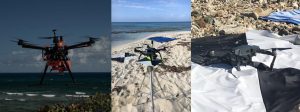
NOAA Evaluates Using Drones to Map Coastline and Nearshore Waters
National Centers for Coastal Ocean Science (NCCOS) scientists and their partners tested the utility of drone technology to map the coastline and nearshore waters of St. Croix in the U.S. Virgin Islands. The team evaluated the quality of land elevation and water depth data acquired by three different drones under a variety of conditions.
Several agencies, including NOAA, need land elevation and water depth data to inform management decisions about the coastal zone. However, many nearshore areas are difficult to access, or are remotely located, making them challenging and expensive to map with existing technologies. Photographs acquired by drones offer a potentially inexpensive and accurate method to fill this data gap at spatial resolutions that far exceed existing technologies. Though, more research is needed to identify optimal drone payloads and parameters, as well as post-processing workflows, before drone technology can be implemented more widely across NOAA.
During the mission, the team mapped six geographic areas in the Buck Island Reef National Monument and the East End Marine Park, collecting over 48,000 digital aerial photos using the DJI S900, 3DR Solo, and DJI Mavic drones. The researchers also collected independent reference data sets to verify the position of the photos and validate the elevations and depths derived from the drone software. The team plans to use data from the mission to develop standard operating procedures for this type of work across NOAA.
The two-year project (Fiscal Years 2017–2019) is funded by NOAA’s Office of Oceanic and Atmospheric Research. The project team includes partners from NCCOS, Oregon State University, Wayne Wright Consulting, NOAA’s Office of Coast Survey, the National Park Service, and the Virgin Islands Department of Planning and Natural Resources.
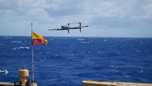
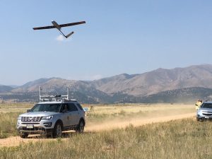
Development of a Hybrid Vertical-Take-Off-and-Landing Fixed Wing Aircraft for Shipboard Operations
In a parallel effort, PMEL is developing an aerosol payload for integration into the HQ-55 with instruments able to measure total particle number concentration, particle number size distribution, aerosol light absorption, solar irradiance and sky radiance, aerosol composition, and meteorological parameters. The payload is modular in design to allow for quick swapping in and out of the UAS so that multiple payloads, each with different measuring capabilities, can be used during a given observation period. A previous version of the payload was flown in the Arctic (Svalbard, Norway) in 2011 and 2015 to investigate climate impacts of soot pollution. Through that work, the aerosol payload transitioned to Technical Readiness Level 8, system demonstration in an operational environment.
First shipboard tests of the HQ-55 with the integrated aerosol payload are planned for Spring 2019 from a NOAA ship. As part of these flights, NOAA AOC pilots will continue training to fly the HQ-55. Through a collaboration between NOAA PMEL, the UAS Program Office, the Office of Marine and Aviation Operations, and the SBIR Program Office, the ultimate goal is to provide a VTOL-FW UAS capability within NOAA for use by all line offices through the Aircraft Operations Center.
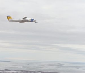
Seahunter Unmanned Aircraft System (UAS) Flights In Northern Alaska
This week collaboration between ESRL PSD researchers Gijs de Boer (CIRES), Janet Intrieri, Christopher Cox (CIRES), and Jackson Osborn (CIRES), and the University of Alaska – Fairbanks Alaska Center for Unmanned Aircraft Systems Integration (ACUASI) flight team resulted in extended operation of the SeaHunter unmanned aircraft system over the Arctic’s Beaufort Sea. The aircraft, carrying the miniFlux payload developed jointly by NOAA PSD and the University of Colorado, set out on a mission from Kuparuk airport to 72.5⁰ N latitude to make important measurements of atmospheric winds and thermodynamic properties as well as map sea ice concentration and sea surface temperature. These observations support development of understanding of the roles of the ocean and atmosphere in fall sea ice development. This airborne activity, in conjunction with oceanic assets deployed as part of the U.S. Office of Naval Research Departmental Research Initiative Stratified Ocean Dynamics of the Arctic (SODA), (SODA), will help to shed light on upper oceanic stratification and its connection to winds and sea ice cover. This activity, supported by the NOAA UAS program office and the National Science Foundation, is continuing over the next two weeks as the sea ice continues its seasonal march towards the Alaskan coastline.
Credit for Photos: Jordan W. Murdock, Robert J. Edison
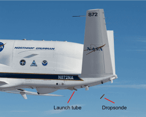
The NCAR/NOAA Global Hawk Dropsonde System
Wick et al. accepted for publication in J. Atmos. Oceanic Technol. A new system enabling the remote deployment of up to 90 dropsondes from the NASA Global Hawk unmanned aircraft was developed through a partnership between the National Center for Atmospheric Research (NCAR) and NOAA. The dropsonde is an instrument, about the size of an empty paper towel roll, that measures the temperature, pressure, and humidity of the atmosphere along with the wind speed and

NOAA UAS Program Well Represented at the AUVSI XPONENTIAL Conference in Denver.
AUVSI XPONENTIAL 2018 is the largest, most comprehensive trade show for unmanned systems and robotics. This year's show was held in Denver from April 30th to May 3rd, and was attended by 8,500 thought leaders from across the spectrum of unmanned systems and robotics to share ideas, gain insight and witness groundbreaking innovation. This year's program included several themes including “Unmanned for Good” which covered unmanned systems used in the wake of multiple hurricanes, wildfires and other natural disasters last year. Unmanned systems across all domains became widely recognized as the future of disaster relief. From search and rescue to humanitarian missions, unmanned technologies were utilized around the world providing aid to those who needed it most.
The Unmanned Aerial System (UAS) Weather Forum was held on April 30th and provided a platform for UAS operators; federal and state agencies; weather researchers and providers; trade groups; safety and insurance groups; UAS manufacturers; and others to:
– Share experiences with expected and unexpected weather impacts
– Engage in a dialogue about weather needs for UAS operations
– Collect requirements for developing better weather guidance
– Cultivate strategies on how to make progress with needed weather support
– Assist regulators with safe integration of UAS into the national airspace system considering weather impacts
– Explore opportunities for using UAS-sensed environmental information for enhanced situational awareness and better weather prediction
– Facilitate weather education & outreach
Chris Hernandez, Sector Vice President, Research, Technology & Engineering, Northrop Grumman gave the final keynote on, and presented the long term view of unmanned technology, reviewing the development of unmanned systems in the military context for 8 decades. Hernandez pointed out that through cooperation with the military and other technology providers, unmanned technology has advanced – and close cooperation between government and industry is what will be required to continue development. He also discussed NOAA and NASA's use of the Global Hawk for hazardous weather research.
John “JC” Coffey chaired three technical sessions included Beyond-Visual-Line-of-Sight (BVLOS) briefs, and Phil Kenul presented on ASTM's F38 organization and structure, current status of the standards developed in support of all Civil Aviation Authority’s (CAA) efforts to integrate UAS into their nation’s airspace (attached) with several members of the NOAA team in attendance.
Additional information on the conference can be found at: https://www.xponential.org/xponential2018/public/Enter.aspx
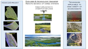
Dr. Curtis Roegner, Ph.D from NOAA’s Fisheries Uses Unmanned Aerial Vehicle System (UAS) for Hyperspectral Imagery
On April 26th, 2018, NOAA's Fisheries, The Department of Energy's Pacific Northwest National Laboratory, National Park Service, Ryka UAS and the NOAA UAS Program Office conducted a post mission for Dr. Curtis Roegner’s Hyperspectral Salmon Habitat Study conducted 2016-17. The following was discussed and had multi-user interest:
Project Scope
- Wetlands directly benefit endangered juvenile salmon by supporting diverse vegetation communities.
- Restoration of degraded wetlands leads to vegetation and topographic changes that require comprehensive monitoring – difficult to accomplish w/traditional means.
- Develop remote sensing techniques employing hyperspectral imagery on a uav to monitor wetland restoration trajectories.
Project Goals
- Equip a UAV system with a hyperspectral imager – completed
- Conduct field measurements, and build Spectral Library – completed
- Develop data analysis routines and analytics for critical metrics -completed
- Test flight optimization and evaluation missions at additional tidal wetland systems – completed
- Codify protocols for remote sensing to aid evaluation of wetland restoration trajectories and management decision making – completed

NOAA UAS Program Hosts National Tribal Interest Group for UAS Webinar
The NOAA UAS Program and DOI’s Bureau of Indian Affairs (BIA) co-hosted the quarterly meeting of the Tribal Interest Group for UAS on April 19th. The NOAA UAS Program and DOI’s Bureau of Indian Affairs (BIA) co-hosted the quarterly meeting of the Tribal Interest Group for UAS on April 19th. Several tribal and non-tribal representatives were present and discussed current Native American UAS operations, future concepts of operations and STEM opportunities. The Bureau of Indian

NOAA Evaluates Drones to Map Coastline and Nearshore Waters
Last month, NCCOS scientists and their partners tested the utility of drone technology to map the coastline and nearshore waters of St. Croix in the U.S. Virgin Islands. The team evaluated the quality of land elevation and water depth data acquired by three different drones under a variety of conditions. Several agencies, including NOAA, need land elevation and water depth data to inform management decisions about the coastal zone. However, many nearshore areas are difficult to
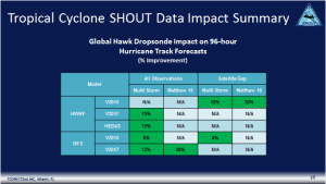
Dr. Jason Dunion Represents the UAS Program Office at the Tropical Cyclone Operations and Research Forum
Brief Topic: Operational Impact of Data Collected from the Global Hawk Unmanned Aircraft During SHOUT The Office of the Federal Coordinator for Meteorological Services and Supporting Research (OFCM) hosted the Tropical Cyclone Operations and Research Forum in Miami 13-15March to bring together the Federal hurricane community: the operational forecast centers; weather modelers; aerial, ocean, satellite, and radar observing groups; and the supporting research functions. The hurricane experts review last year’s hurricane challenges, plan operations for the upcoming
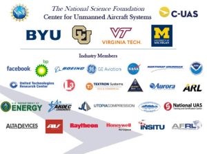
NOAA UAS Program Hosts National Science Foundation (NSF) Center for Unmanned Aircraft Systems (C-UAS) Webinar
C-UAS’ Director, Brad Whitby, to brief and identify NOAA scientists as technical leads for existing and future C-UAS R&D opportunities. The NOAA Unmanned Aircraft Systems Program Office (UASPO) has funded the National Science Foundation (NSF) Center for Unmanned Aircraft Systems (C-UAS) to conduct UAS R&D for platforms, sensors and applications to examine NOAA observation requirements. Purpose of the Meeting: C-UAS was established in 2012 and is an Industry/University Cooperative Research Center involving Brigham Young