
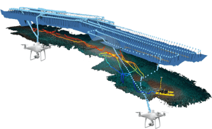
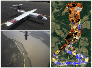
Bathymetric Mapping and Orthoimage Generation using sUAS and SfM, An Approach for Conducting Nearshore Coastal Mapping
The use of commercially available unmanned vehicles have become increasingly common in coastal areas. This work was funded by NOAA’s Unmanned Aircraft Systems Program Office (UASPO) through its federal funding opportunity. Our research was designed to support NOAA OCS’s nautical charting needs in shallow (<10 m) waters. NOAA OCS is developing procedures to operate sUAS from hydrographic vessels. The methods described here will be companion to these operational procedures, and together will help move this technological approach from research towards operations at NOAA. In addition working to meet NOAA OCS’s needs, there has been substantial interest in sUAS applications beyond nautical charting from other NOAA offices, federal agencies, state agencies and non-governmental organizations. This interest has ranged widely from mapping and monitoring coastal habitats to surveying marine animals to observing human activities in coastal environments. Efforts are currently underway to build on the research described here, and continue to design and test new applications for commercially available unmanned vehicles at NOAA NCCOS.
Nighttime Fire Observations eXperiment (NightFOX) Update
Biomass burning produces major impacts on local and regional air quality and potentially plays an interactive role in climate change. A capable small, fixed-wing unmanned aircraft system (sUAS) can serve as an ideal platform for measurements of biomass burning emissions, plume distribution, fire extent and perimeter, and supporting meteorological data, especially at night when manned aircraft typically do not operate. The NOAA UASPO-funded Nighttime Fire Observations eXperiment (NightFOX) project aims to develop and deploy a sUAS observation system utilizing two modular and easily exchangeable payloads. One payload will provide in situ measurements of CO2, CO and fine- and coarse-mode aerosol size distributions in biomass burning plumes for characterization of fire combustion efficiency and emissions. A filter sampler will collect bulk aerosol samples for off-line composition analysis. The second payload will be flown over the fire to make remote sensing measurements of fire perimeter and fire radiative power using visible and short-, mid-, and long-wavelength IR observations. The multi-spectral remote sensing data will be used to provide sub-pixel information for comparison with satellite fire observations, and along with measured meteorological parameters, will be used to inform, test, and improve the WRF-SFIRE fire-atmosphere model.
On 31 July 2019, the NightFOX remote sensing payload onboard a Black Swift Technologies S2 UAS was used to monitor a prescribed burn in Boulder County, CO. The experiment was very successful, producing a fire map and demonstrating the capability and usefulness of the system (see associated figures and video). For the next step we plan to deploy the system to make measurements over real wildfires in the western US in August and September 2019.
This project is funded by the NOAA UAS Program Office, and includes a partnership between NOAA ESRL/CSD and the University of Colorado Boulder.
Chequamegon Heterogenous Ecosystem Energy-Balance Study (CHEESEHEAD’19)
The NOAA Air Resources Laboratory (ARL) Atmospheric Turbulence and Diffusion Division (ATDD), supported by the UAS Program Office, is participating in the Chequamegon Heterogenous Ecosystem Energy-balance Study Enabled by a High-Density Extensive Array of Detectors 2019 (CHEESEHEAD'19) campaign near Park Falls, Wisconsin (Figure 1). The aim of CHEESEHEAD'19 is to study interactions and feedbacks between the land surface and atmosphere and to improve how these interactions are represented in weather and climate models.
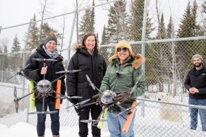
During three week-long campaigns in July, August, and September 2019, NOAA ATDD is operating two small Unmanned Aircraft Systems (sUAS). ATDD is using a DJI S-1000 (Figure 2) to obtain in-situ temperature and moisture measurements, along with land surface temperature measurements from a downward-pointing infrared camera, in the vicinity of 30-m (100-ft) towers installed in the CHEESEHEAD domain by partners from the National Center for Atmospheric Research (NCAR) (Figure 3). These towers are instrumented with a myriad of instruments to sample different meteorological variables (e.g., temperature, moisture, and wind), as well as exchanges of heat and moisture between the land surface and overlying atmosphere. These tower measurements, combined with the sUAS measurements, are then used to estimate the variability in heat exchange in the region surrounding the tower. Within a ~ 500 x 500 m area surrounding the tower, there is significant variability in temperature, with differences on the order of 10 °C over this area (Figure 3).
In addition to the DJI S-1000, ATDD is also operating a Meteomatics SSE (Figure 4) during CHEESEHEAD. This platform is used for obtaining vertical profiles of temperature, moisture, and wind. In the example from the morning of 12 July, ATDD performed 4 flights adjacent to one of the NCAR meteorological towers. These flights show the growth and evolution of the atmospheric boundary layer (i.e., the lowest part of the atmosphere directly affected by the surface), as well as increase in near-surface moisture (Figure 5). During the August and September CHEESEHEAD campaigns, ATDD will fly the Meteomatics adjacent to the NOAA Global Monitoring Division (GMD) 447-m Park Falls tall tower, which is outfitted with an array of meteorological measurements at multiple heights, to evaluate wind speeds and wind directions derived from the Meteomatics.
Fusion of LiDAR and Hyperspectral Imagery to Monitor Wetland Restoration Benefiting Salmon
Effective restoration of wetlands from anthropogenic stress is a critical research priority worldwide, and in the Pacific Northwest of the US there is a heightened relevance for supporting recovery of listed and endangered salmon. Wetland vegetation communities are especially important for shelter and as a source of invertebrate prey preferred by juvenile salmon during migration to the ocean. While many new restoration projects have commenced in recent years, often lacking is the means for evaluation of the restoration effectiveness. This evaluation includes quantification of the trajectory of physical systems and vegetation communities from initial states towards those more beneficial to desired outcomes (e.g. fish survival). Typical wetland/estuarine vegetation and topographic surveys are expensive, time-consuming, and restricted in spatial and temporal cover, difficulties that until now have limited evaluation of restoration trajectories toward recovery.
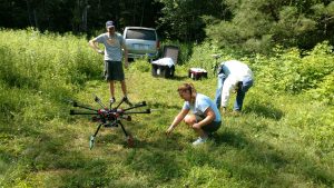
This project is supported by funding from the UAS Program Office, and includes a partnership between NOAA Fisheries, Pacific Northwest National Laboratories, RykaUAS, and the National Park Service, has developed a UAS for remote sensing of vegetation types using a 110-band imaging spectrometer (BaySpec OCI) flown on a DJI Matrice 600 hexacopter. We established a library of ground-truthed “spectral signatures” from wetland plant species and analytical routines allowing for output of categorized maps and statistical metrics. The next phase of the project entails integrating a LiDAR (RIEGL miniVUX-1UAV) instrument for determining topography-vegetation species relationships and to track landform changes as restoration projects evolve over time. Fusing the vegetation and topographic data offers a means for the rapid and comprehensive assessment of habitat metrics with minimal additional ground truthing, and provides methods to evaluate the effectiveness of management actions.
High-Altitude AirCore-Glider System
The Global Monitoring Division (GMD) of NOAA’s Earth System Research Lab (ESRL) has revolutionized high-altitude trace gas sampling with the balloon-borne AirCore sampling system, which is capable of collecting samples up to altitudes of 30 km. Over 120 AirCores have been launched, recovered and analyzed for a variety of trace gases, providing profiles of more than 98% of the atmospheric column for carbon dioxide (CO2), methane (CH4), and carbon monoxide (CO). These profiles provide valuable information for satellite validation and some of the only trace gas measurements available in the lower to mid-stratosphere unreachable by most aircraft. The current system is limited in profiling locations due to the feasibility of its recovery. The proposed study provides a critical path to make the sampling of 98% of the atmospheric column operational almost anywhere in the world by enabling a controlled UAS recovery of the AirCore sampling system and its accompanying in situ measurements package. GMD’s new project technology, under development provides a platform and an operational pathway for many other high accuracy measurements that would benefit from a dependable recovery system while at the same time providing the capability to reach altitudes that no manned aircraft are capable of reaching.
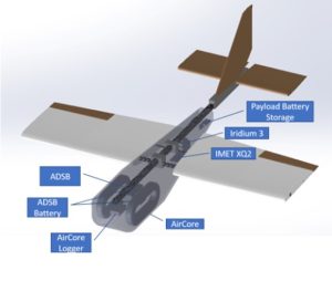
Double AirCore string using 3000 g weather balloon which includes two AirCores, AD-B transponder, balloon cutter, iMet radiosonde and parachute (Figure 1). The parachute automatically deploys at balloon burst at around 100,000 feet and falls to the ground as much as 70 miles downwind of the launch location. The AirCore captures the full profile of atmosphere which is later analyzed for CO2, CH4 and CO providing more than 100 independent measurements in the atmospheric column from 0 – 100,000 feet above sea level.
Figure 2 is 3D sketch of glider system for AirCore payload. This system carries two AirCores, AD-B transponder, balloon cutter, iMet radiosonde and parachute in a single payload that is designed to glide at roughly a 11:1 glide ratio from 100,000 feet enabling the AirCore package to be returned to the launch location normal weather conditions. This system is designed to carry slightly more than 12 lbs.

Montreal Protocol Violation and a Hawaiian Lava Flow…Using a Hexacopter to Replace a 100 ft. Sampling Tower
Air samples collected through an air-line supported 100 ft. above ground level on a tower at Cape Kumukahi, Hawaii, showed that a multi-decade long decline in CFC-11, a stratospheric ozone depleting gas controlled by the Montreal Protocol, is stalling. In a paper published in Nature, May 2018, NOAA Global Monitoring Division scientists show this disallowed CFC-11 production is coming from eastern China, 10,000 km upwind of Cape Kumukahi (Figure 1).
During recent eruption access to the Cape Kumukahi tower was destroyed by a 30 ft. high wall of hot lava which also destroyed the road, inundated the area, cut the power line and terminated sampling from the tower (Figure 2). In May 2018 subsequent air samples collected at the surface near the tower site were not of acceptable quality (Figure 3). By way of reference, ozone depleting gas concentrations are measured in parts per trillion (ppt) or better.
To visualize a ppt, here is an analogy. If you have a wall of silver dollars 6 ft. wide by 6 ft. tall, 200 miles long, there will be about one trillion silver dollars in that wall. Take one of those coins out of the wall and scratch it. NOAA Global Monitoring Division scientists will tell you where in that wall the coin came from, and on what side the coin was scratched, 99 times out of a 100. Some CFC-11 measurements require determining concentrations to a 10th of a ppt. Following the above analogy, the wall of silver dollars would be 2,000 miles long but the measurements would still pinpoint the scratched coin’s location, 99 out of 100 times.
In order to reestablish the Cape Kumukahi measurement program with the same sampling parameters as prior to the lava flow, it is necessary to sample air from near to the same location and altitude. A replacement tower may never be built as the cost for road, power line and tower would be in the million $ scale. As a possible replacement a tethered UAS hexacopter system has been developed to accomplish the same sampling parameters, at the same sight at a much reduced cost.
Specifically via UAS Program Office support, the Global Monitoring Division will use a tethered DJI 600M hexacopter to pull up an air sampling line to 100 ft. and hover while flasks are filled with a pump at the surface (Figure 4). The hexacopter will be powered by either batteries or powered by a generator operating on propane. The sampling line weighs 2.5 lbs. whereas the hexacopter can carry 6 lbs. Operations in winds up to 20 mph should be possible. Prior to deployment, the efficacy of the system and any possible contamination issues will be thoroughly vetted at the NIST Table Mesa test facility near Boulder, CO.
The hexacopter and tether system components will arrive in late September 2019 with field testing in November and modifications/sample QA/QC in December 2019. If all goes as planned, deployment to Hawaii will be in January/February 2020 with additional QA/QC and test operations at Cape Kumukahi. Assuming all operator training, safety, logistics QA/QC and permissions are completed, the system should become operational with weekly sampling beginning in March 2020. This resumption of measurements will be timely as China has agreed to comply with the Montreal Protocol immediately (Nature, May 2019). The NOAA Cape Kumukahi measurements will assist in verify the compliance.
This tethered hexacopter system will be relatively cheap for above ground surface sampling, is highly mobile and could be deployed globally and hence facilitating collecting air samples under many different scenarios in a variety of environments.
Forecast for Harmful Algal Blooms in Lake Erie 2019
The UAS Program Office is supporting Dr. Stumpf, (NOAA/National Centers for Coastal Ocean Science (NCCOS), on a project where the goal is to use sUAS (small Unmanned Aircraft Systems) to deploy harmful algal bloom (HAB) sensors and to develop and demonstrate a rapid, cost-effective response capability in order to more quickly and accurately know the location of bloom patches. Advancing this real-time detection capability would enable states (especially Florida) and counties to more effectively deploy and focus their limited sampling resources. Furthermore, this capability would enhance NOAA’s HAB forecasting capability so as to be able to provide improved warnings to the public, and therein increase public safety and reduce economic impact. This capability, once demonstrated, will be transitioned to states for integration into their HAB monitoring programs. Improved HAB forecasting is identified as an agency priority in the NOAA Next Generation Strategic Plan Objective – Improved coastal water quality supporting human health and coastal ecosystem services and as a Line Office mission goal in NOS Priorities Roadmap, under “Threats to human health and safety from ecological hazards”.
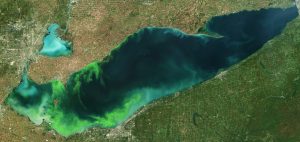
On July 11, 2019 Dr. Richard Stumpf attended a Harmful Algal Bloom (HAB) Workshop (“Forecast for Harmful Algal Blooms in Lake Erie 2019”) hosted by Ohio Sea Grant & Stone Lab. At the workshop, he presented the seasonal forecast for the HAB in western Lake Erie, developed by NOAA and its research partners. Western Lake Erie will experience a significant harmful algal bloom (HAB) this summer, expected to measure 7.5 on the severity index, but could range between 6 and 9. An index above 5 indicates blooms having greater impact. The severity index is based on bloom's biomass – the amount of algae – over a sustained period. The largest blooms occurred in 2011, with a severity index of 10, and 2015, at 10.5. Last year’s bloom had a severity index of 3.6, while 2017's was 8.0.
Lake Erie blooms consist of cyanobacteria, also called blue-green algae that are capable of producing the liver toxin microcystin that poses a risk to human and wildlife health. Such blooms may result in higher costs for cities and local governments that need to treat drinking water, prevent people from enjoying fishing, swimming, boating and visiting the shoreline, and harm the region’s vital summer tourism economy. These effects will vary in location and severity due to winds that may concentrate or dissipate the bloom.
“Communities along Lake Erie rely upon clean, healthy water to support their community’s well-being and economic livelihoods,” said Nicole LeBoeuf, acting director of NOAA’s National Ocean Service. “This forecast provides timely and trusted science-based information to water managers and public health officials so they can better anticipate blooms, mitigate impacts and reduce future outbreaks.”
This year, the lake temperature has remained relatively cool due to the higher-than-average rainfall in the region, so the bloom is not expected to start until late July when the water temperature reaches 65 to 70 degrees F. This contrasts with 2018, when exceptionally warm weather at the beginning of June caused an early start. Calm winds in July, especially in western Lake Erie, tend to allow the algal toxins t
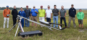
Operational Evaluation of Planck Aerosystems “Shearwater” Small Unmanned Aircraft System (sUAS) in the Santa Barbara Channel July 29 – 31, 2019
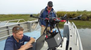
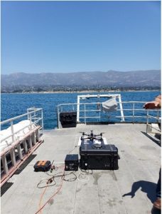
Channel Islands National Marine Sanctuary CINMS) / Collaborative Center for Unmanned Technologies (CCUT) staff supported the field testing of a Planck Aerosystems “Shearwater” sUAS aboard the NOAA Research Vessel Shearwater (Figure: 1) and the salvage vessel Danny C (Figure: 2). in the Santa Barbara Channel July 29 – 31, 2019. The project was funded by the NOAA OAR UAS Program Office. In participation were LTJG Nicole Chappelle from the NOAA OMAO Aircraft Operations Center Co-PI Alan Jaeger from the US Navy and project PI Todd Jacobs of ONMS CCUT. The goals of the project are to evaluate the Shearwater UAS's capabilities to safely and reliably take off and land autonomously from moving vessels and to be operated in a tethered mode, where it can stay in the air for extended periods. The Shearwater UAS was able to successfully take off and land autonomously in relative wind up to 21 knots and from the R/V Shearwater at speeds up to 18 knots. The tethered mode was also successfully demonstrated, but at lower wind speeds.
The autonomous take-off and landing capability is thought to reduce risk and will require less operator proficiency when operating from boats. The tethered mode may eventually support incidents such as whale disentanglements and could serve as a data or communications relay during oil spills or other emergency operations.
The next phase of the project is to support NMFS and NOS by providing aerial imagery to manta ray tagging teams ~100 miles offshore at the Flower Garden Banks National Marine Sanctuary from August 5 – 8, 2019.
A third phase of testing and Shearwater UAS operator training is planned for December 16 – 20 to be conducted in concert with the annual whale disentanglement training in Maui, HI, which will be hosted by project co-PI Ed Lyman at the Hawaiian Islands Humpback Whale National Marine Sanctuary.
These evaluations will be reviewed by the Office of National Marine Sanctuaries (ONMS), (CCUT) and OAR UASPO and will be used to determine whether one or more Planck Aerosystems “Shearwater” UAS will be purchased by the agency and transitioned to routine operations.
NOAA UAS Program Briefing at the 3rd Federal UAS Workshop
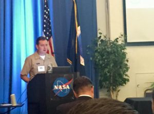
Captain Philip Hall, Director of the NOAA UAS Program Office in OAR, was invited to provide one of several impactful briefings at this year's UAS Federal Workshop in May at NASA Ames, an event that was co-hosted by NASA and USGS. Commensurate with the goals of the workshop, the 3rd one in as many years, Captain Hall shared an overview of the NOAA UAS Program's many diverse activities and projects, highlighting its partnerships and efforts in working both within and outside of NOAA to accomplish common goals that will ultimately benefit society. Other federal agencies were also in attendance and provided similar overview briefings, including but not limited to, NASA, Federal Aviation Administration, U.S. Geological Survey, National Science Foundation, U.S. Army Corps of Engineers, Federal Emergency Management Agency, Department of Interior, U.S. Forest Service, National Geospatial-Intelligence Agency, U.S Department of Agriculture, and the Environmental Protection Agency.
One of the primary goals of the workshop was to share lessons learned and update the audience on UAS policy issues, operational challenges, and upcoming opportunities on which this federal community either could or needs to collaborate. Opportunities to bring so many disparate agencies together provides opportunities to continue using partnerships to accelerate UAS-deployed sensors and provide CONOPS to fill important national observational gaps. By approaching these challenges with a whole-of-Government team, successes within our federal agencies can be leveraged to accelerate our national UAS enterprise. It also enables the group to focus resources on shared challenges and new opportunities. Furthermore, the annual workshop helps many of the representing agencies to explore how to respond to rapidly evolving emergencies like floods, volcanic eruptions, wildfires, and hurricanes, and how to use new tools like artificial intelligence and machine learning to accelerate the rapid exploitation of collected UAS data.

Shipboard Launch and Recovery of Unmanned Aerial Systems and Scientific Payloads
Measurements of vertical profiles of aerosol properties combined with meteorological parameters have primarily been limited to the use of manned aircraft which are expensive to operate and require extensive ground support. Unmanned Aerial Systems (UAS) provide a means to obtain these measurements at much lower cost from ships and land based regions not easily accessed by manned aircraft. The lower cost of UAS operations allows for frequent flights as part of long term monitoring or during intensive field experiments. These observations will help to improve air quality forecasts including those related to emissions from forest fires and industrial activities. In addition, these observations will be used to improve and validate aerosol radiative forcing estimates computed with coupled chemical transport and climate models. The cost of repeated UAS flights relative to manned aircraft allows for statistically significant data sets of aerosol properties of the lower atmosphere (surface to 12,000 ft). In addition, these measurements address NOAA’s Long-Term Goals of improved understanding of the changing climate system and its impact on health of people and communities due to improved air quality.
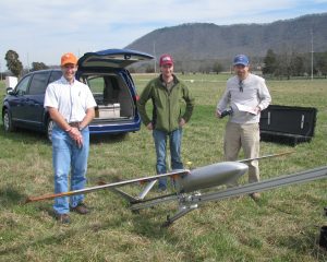
In 2018 working with the Pacific Marine Environmental Laboratory (PMEL), L3 Latitude was awarded a Phase II NOAA SBIR to ready the HQ-55 for commercial production. This UAS uses a Hybrid Vertical Take Off and Landing (VTOL) – Fixed Wing (FW) technology to allow for autonomous launch and recovery from confined spaces without the need for a runway or catapult. Once launched, the UAS transitions to fixed wing flight with an endurance of up to 10 hours, a ceiling of 12,000 ft, and the ability to carry up to a 15 lb payload. The payload nose cone can be used to house different instrumentation dependent upon the mission. One of these payloads contains instruments for the measurement of total particle number concentration, particle number concentration as a function of particle size, aerosol light absorption coefficient, aerosol optical depth, and aerosol chemical composition. Dr. Patricia Quinn (PMEL) serves as the technical point of contact (TPOC) for the project. Successful test flights with the aerosol payload onboard the HQ-55 took place in April 2019 at the Florence Military Range near Tucson, AZ. An altitude of 7500 ft. MSL (9,300 ft. density altitude) with data from all functioning payload instruments recorded onboard.
With assistance from UAS Program Office, SBIR acceptance testing is planned to be conducted at-sea May 28 to June 1, 2019 with L3 Latitude’s HQ-55 (Figure 1). These first shipboard flights of the HQ-55 will take place on the NOAA RV Ronald H. Brown (Figure 2) during a transit from Woods Hall, MA to Charleston, SC. The goal of this acceptance testing and exercise is to continue to demonstrate the upgraded Hybrid Quadrotor (HQ) technology from a ship with limited deck space and to validate the moving baseline differential GPS and ship landing logic. The UAS will take off from the ship, switch to fixed wing flight, and return and land on the ship. This series of events will be repeated multiple times to build up experience with ship board operations. In addition atmospheric profiles are planned to be completed in the Area of Operation of the ship.
The ultimate goal is to transition “Shipboard Launch and Recovery of Unmanned Aerial Systems with Aerosol Payload Capabilities” from a research platform to a long-term sustained operational capability within NOAA/OAR with NOAA/OMAO providing logistical and asset support.
The next phase of research advancement is to expand on these successes and provide for an operational capability. As part of this plan, NOAA will acquire the UAS which will be maintained and flown by NOAA’s Aircraft Opera
Another One in the Books… NOAA UAS Science Team Completes Second Milestone Operation to Aid Hydrologists with Improving Flood Forecasts
For the second time in two months, NOAA's Northern Gulf Institute (NGI) and Mississippi State University's Raspet Flight Research Laboratory successfully executed UAS operations to provide data to the National Weather Service's (NWS) Lower Mississippi River Forecast Center (LMRFC). With funding provided by the NOAA UAS Program Office, and in response to expressed needs for aerial imagery by the LMRFC following a historic rainfall event, Dr. Robert Moorhead (Director of NGI and principle investigator of the “SHOUT4Rivers” parent project) and his team conducted operations of a large, “Group 3” UAS over vast areas of flooding near Greenwood, MS in February 2019. The primary goal for that first mission was to provide forecasters with critical information to indicate water level heights and show locations of inundation. The data was transmitted in near real-time to the LMFRC office in Slidell, LA to help hydrologists update flood warnings and generate more accurate forecast products for use by emergency managers and the general public. “We were able to see the water as it rose over the course of two days, which helped our office confirm when the crest had been reached,” said Dr. Suzanne Van Cooten, hydrologist-in-charge at the LMRFC.
Now following those successful February operations, the crew was recently tasked with yet another important mission to help fulfill more NWS LMRFC data needs. With additional heavy rainfall events from March and April, exasperating flood conditions in several not-yet-fully recovered locations, the team was deployed this time to Greenville, MS, with operations taking place in a critical area along the Mississippi River in late April. As was the case with the previous operation, large swaths of areal imagery were mapped and will be mosaicked together before being sent to NWS forecasters in Slidell to provide them with actual inundation maps that will help them verify and update their models. This type of data contains a wealth of new information, going well beyond that of the individual water gauge point data that these forecasters must typically rely upon.
During this second mission, Dr. Moorhead's team was also able to achieve a few more accomplishments. In addition to executing operations from an entirely new base location, across the river at the Lake Village Municipal Airport in Arkansas, the crew maintained enhanced situational awareness by streaming and archiving real-time video directly from the platform. Also, with the mission taking place on what was an otherwise typically busy day for manned agricultural aircraft operations in the area, another big milestone demonstrated was the ability to seamlessly integrate the UAS platform into the take off and landing pattern there at an active airport. John Walker, a Cherokee Nation Strategic Programs contractor, supporting the NOAA UAS Program Office, said of the operation, “It was very interesting to observe how all of the local pilots and airport management staff really took to
Multi-spectral Imaging of Polar Bears at Cochrane Polar Bear Habitat
During the first week of April, NOAA researchers from the Alaska Fisheries Science Center’s Marine Mammal Laboratory (MML) collected multi-spectral imagery of polar bears at the Cochrane Polar Bear Habitat in Ontario, Canada. Color, infrared, and ultraviolet photos were collected using two APH-28 hexacopters. This ongoing work was partially funded by the UAS Program. One platform carried the FLIR Duo Pro R camera and the other carried a new UV payload (developed by Ben Hou at MML) paired with a color camera and laser altimeter. This imagery will help improve remote sensing of bears during aerial surveys for ice-associated seals and polar bears on the sea ice habitat of the Bering, Chukchi, and Beaufort seas. The team also collected thermal data of resting bears and bears coming out of cold water to see how these behaviors affect the thermal signature detected from the airborne cameras. Multi-spectral imagery of bears on ice, in open snow fields, and near rocks will be used in the development of an automated bear detection model in support of upcoming international survey efforts of the Beaufort Sea for ice seals and polar bears. NOAA’s Canadian partners primary focus is bears, so this work also helps build that partnership so we can get more meaningful seal data from the full Beaufort surveys. Polar bears are listed as threatened under the ESA (as are ringed and bearded seals).

DRONE TRAINS ITS EYES ON FLOOD WATERS TO IMPROVE FORECASTS
As the Yalobusha River rose around Greenwood, Mississippi, during a major rainstorm in late February, scientists from the Northern Gulf Institute at Mississippi State University deployed a small unmanned plane that took high-resolution images of rising waters and beamed them back in real time to NOAA weather forecasters.
We were able to see the water as it rose over the course of two days, which helped our office confirm when the crest had been reached,” said Dr. Suzanne Van Cooten, hydrologist-in-charge at the NOAA National Weather Service Lower Mississippi River Forecast Center in Slidell, Louisiana. “This visual information really helps us improve our forecasts so we can provide critical information to those in an affected area.”
Scientists piloted the 8.5-foot long by 14-foot wide Griffon Outlaw G2E unmanned plane from MSU’s Raspet Flight Research Center in Starkville, Mississippi, equipped with the Overwatch Imaging TK-5 payload — a system able to take, process and transmit images with 6-inch resolution when flying 4,500 feet above the ground.
The images (Figures 1 and 2) typical real time images for NOAA and FEMA were transmitted to the High Performance Computing Collaboratory at MSU, and could be immediately downloaded by NOAA’s NWS Lower Mississippi River Forecast Center. NOAA forecasters used the information to refine forecasts that are vital to local emergency managers, the public and the area’s farmers.
In a parallel effort, the data was also downloaded by the Federal Emergency Management Agency Region 4 for real-time examination and assessment. “Aerial imagery and other data made available from unmanned aircraft systems is increasingly showing its value as a resource to provide our local, state, and federal emergency managers with actionable information needed to most effectively perform their duties,” said Travis Potter, Remote Sensing and UAS Coordinator for FEMA 4. “The information provided from this operation could be extremely useful toward helping folks on the ground to efficiently distribute resources, manage evacuations, and aid in future recovery efforts.”
Once the plane landed, scientists retrieved higher resolution images stored onboard that can now be used to improve flood prediction models.
“We’re really pleased with the results of this fixed-wing unmanned aircraft system,” said Capt. Philip Hall, director of NOAA’s Unmanned Aircraft Systems Program. “The unmanned aircraft and payload shows great potential to provide forecasters with valuable data to improve forecasts as well as flood models. We look forward to continuing to work with the Northern Gulf Institute and NOAA’s National Weather Service to transition the technology into operations.”
NOAA Scientists and Engineers Conduct sUAS Test in Florida
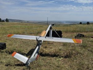
On March 4-6, a team of nine NOAA scientists and engineers gathered at Avon Park, a U.S. Air Force (USAF) test range north of Sebring, Florida, to conduct first-of-a-kind tests on two small unmanned aircraft systems (sUAS). The team consisted of personnel from the Atmospheric Turbulence and Diffusion Division (ATDD) of NOAA’s Air Resources Laboratory, NOAA’s Unmanned Aircraft Systems Program Office (UASPO), and NOAA’s Office of Marine and Aviation Operations (OMAO) Aircraft Operations Center (AOC). The two sUASs being tested were recently acquired by ATDD. They are a Meteomatics Meteodrone Severe Storms Edition (SSE), which performs vertical takeoffs and landings, and a BlackSwift Technologies S2 fixed-wing aircraft similar in design to an airplane.
The tests were very successful. Over the three-day testing period, the team performed over a dozen flights with the Meteodrone and six flights with the S2. The Meteodrone was flown up to a maximum altitude of 950 m above ground level (AGL), whereas the S2 reached 1200 m AGL during one of its flights. A ground-based radar system, integrated with geospatial software, was deployed in an attempt to determine its capability to mitigate potential threats to these sUAS(s) by targets within the airspace (e.g., traditional airplanes, other sUAS(s), hot air balloons, birds, etc.). During all tests, the ground-based radar system detected both the Meteodrone and S2, as well as other air traffic in the area. To further evaluate the ground-based radar system, on 5 March a NOAA Twin Otter aircraft performed multiple flyovers of the site, and the ground-based radar system detected this aircraft as well. Additionally, Meteodrone data were used to generate analyses of temperature, moisture, and wind fields in near real-time using the Meteomatics software package.
Since Avon Park is a USAF bombing range which NOAA AOC has utilized to test both full-size and drone systems in the past, its airspace is not subject to the same Federal Aviation Administration (FAA) restrictions imposed on the national airspace system. The relaxed limitations enabled the team to fly both aircraft to their respective maximum flight altitudes. Knowing each aircraft’s upper limit and the point at which the operator would lose visual line of sight were key to performing safer, higher flights in the future. Essentially, this exercise enabled the team to measure the same kind of parameters used by air traffic controllers.
Taking measurements of temperature, relative humidity, wind speed and pressure (collectively known as vertical profiles) with a copter and fixed-wing aircraft at such a high altitude hasn’t been done before, so scientists were unsure what to expect. Historical data is sparse, so there has always been a large gap in knowing what is happening with the thermodynamics and kinematics of the atmosphere (e.g. the transformations responsible for weather and climate). Flying the sUAS(s) to higher altitudes enables scientists to design increasingly useful experiments to study the boundary layer – the lowest few kilometers of the atmosphere where we live, where weather occurs, and where ARL focuses its research.
NOAA’s AOC and UASPO are working to obtain Certificates of Authorization (COA) from the FAA to fly up to 10,000 ft. Once COAs are obtained, both of ATDD’s sUAS(s) will be used for vertical profile sampling within the lowest few kilometers of the atmosphere. Higher altitude, more frequent measurements will greatly enhance operational weather forecasting by the National Weather Service (NWS) through analysis of the observations, and inclusion of the data into numerical weather prediction models. These data will also help refine future field intensive studies of the boundary layer. The test at Avon Park paves the way toward eventually having autonomou
ARL, UASPO, and AOC Collaboration Set to Perform Groundbreaking Field Study
On March 4-6, a team of nine NOAA scientists and engineers will gather at Avon Park, a U.S. Air Force (USAF) test range north of Sebring, Florida, to conduct first-of-a-kind tests on two small unmanned aircraft systems (sUAS). The team consists of personnel from the Atmospheric Turbulence and Diffusion Division (ATDD) of NOAA’s Air Resources Laboratory, NOAA’s Unmanned Aircraft Systems Program Office (UASPO), and NOAA’s Office of Marine and Aviation Operations (OMAO) Aircraft Operations Center (AOC). The two sUASs being tested are recent acquisitions by ATDD. They include a Meteomatics Meteodrone Severe Storms Edition (SSE), which performs a vertical takeoff and landing (Figure 1), and a BlackSwift Technologies S2 fixed-wing aircraft similar in design to an airplane (Figure 2).
Since Avon Park is a USAF bombing range, which NOAA AOC has utilized to test both full-size and drone systems in the past, its airspace is not subject to the same Federal Aviation Administration (FAA) restrictions imposed on the national airspace system. The relaxed limitations will enable the team to fly both sUAS(s) to their respective maximum flight altitudes of approximately 5,000 feet above ground level (AGL). Knowing each aircraft’s upper limit and the point at which the operator will lose visual line of sight are key to performing safer, higher flights in the future. During testing, the team will also employ a ground-based radar system integrated with geospatial software in an attempt to determine its capability to mitigate potential threats to the sUAS(s) by targets within the airspace (e.g. traditional airplanes, other sUAS(s), hot air balloons, birds, etc.). Essentially, this exercise will enable the team to measure the same kind of parameters used by air traffic controllers.
Taking measurements of temperature, relative humidity, wind speed and pressure (collectively known as vertical profiles) with a copter and fixed-wing aircraft at such a high altitude represents a new frontier for atmospheric observations and is currently being done operationally in only a few locations around the globe. Historical data is sparse, so there has always been a large gap in knowing what is happening with the thermodynamics of the atmosphere (e.g. the transformations responsible for weather and climate). Flying the UAS(s) to higher altitudes will enable scientists to design increasingly useful experiments for the boundary layer – the layer of the atmosphere where we live, where weather happens, and where ARL focuses its research.
NOAA’s AOC and UASPO are working toward obtaining Certificates of Authorization (COA) from the FAA to fly up to 10,000 ft. Once COAs are obtained, both of ATDD’s sUAS(s) will be used for vertical profile sampling within the lowest 1 km of the atmosphere. Higher altitude, more frequent measurements will greatly enhance operational weather forecasting by the National Weather Service (NWS), as well as future field intensive studies of the boundary layer. The upcoming field test is paving the way toward eventually having autonomous vertical profiles occurring any time of the day in different locations around the U.S. Currently, there are only about 100 NWS weather forecast offices in the U.S. that perform vertical profiling. They all utilize weather balloons for this twice-daily analysis. ATDD plans to start working with its closest forecast office, in Morristown, Tennessee, to determine how more frequent, more localized vertical profiles help to improved forecasting. ATDD is also continuing to assess new technologies and instrumentation capable of utilization by UAS(s).