
Surveying Antarctic Predators to Inform Fisheries Management
NOAA Fisheries’ Antarctic Ecosystem Research Division (AERD) studies and monitors several species of seals and penguins that are indicators of the health of the regional fishery for Antarctic krill. Krill are the focus of an expanding international fishery in the Antarctic, but are also a fundamental food source for the region’s fish, marine mammals, and birds. Accurate census counts and measurements of body condition are fundamental to seal and penguin population management, but can be difficult to obtain in remote polar environments. Funding from the UAS Program Office partially supports said studies.
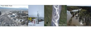
Building an Operational Program for Small UAS for Flood Mapping and Routine Equipment Inspection at NWS Alaska
In Alaska, flooding is the most frequent cause of state disaster declarations. Ice jam floods during spring break-up have devastated many communities along waterways in the large Yukon and Kuskokwim River basins over the past century. Snowmelt and heavy precipitation can cause flooding in the spring and summer time. Alaska also faces frequent impacts from the outbursts of glacially dammed lakes. For many years, the Alaska-Pacific River Forecast Center (APRFC) has depended on partners to help monitor flood conditions in remote communities on the ground or in small aircraft. Building in-house capabilities to deploy small Unmanned Aerial Systems, helps bring cutting edge data collection to the decision-support services at the National Weather Service.
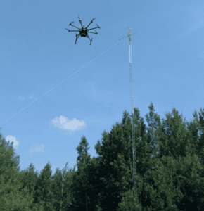
Observing Atmospheric Fluxes with UAS (miniFlux)
Understanding the transfer of heat and momentum between different layers of the atmosphere and the underlying surface is critical for improving our weather and climate forecasts. Scientists at NOAA’s Physical Sciences Division (PSD) and the University of Colorado’s (CU) Cooperative Institute for Research in Environmental Sciences (CIRES) are working to develop, test, calibrate and deploy the compact, lightweight (1.2 lbs) miniFlux sensor system (Figure 1). This miniaturized instrument, which is supported by NOAA’s UAS Program Office, can reliably collect these measurements from unmanned aircraft systems (UAS). Deploying this lightweight package on UAS over difficult-to-sample regions of the Earth can provide perspectives on these important processes in ways not previously possible.
sUAS Bathymetric Mapping for Featureless Bottom Topography Using Naturally Occurring Structure Light
Unmanned aircraft systems (UAS) with Flash Structure from Motion (SfM) capabilities are of great interest as a supplement to existing technologies for marine debris detection, reef restoration, and ship-grounding impacts. Coastal storms and geo-hazards, including hurricanes, nor’easters and tsunamis, can deposit marine debris over vast areas, threatening marine ecosystems and navigation safety. Identification and geolocation of the debris is necessary to direct removal efforts, but can be a challenging and expensive task. These events can also cause significant damage to coral reef communities and even dislodge corals. Restoration triage to “replant” the damaged corals is time critical. Additionally, ship-grounding incidents caused by coastal storms require accurate and rapid information to conduct damage assessment and recovery efforts. The available geospatial information collected after Hurricanes Maria and Irma, which heavily impacted the U.S. Caribbean and beyond, clearly indicate the limitations of current coastal intelligence abilities to addressing disaster impacts in the littoral zone.
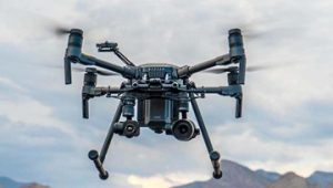
Developing DJI M210RTK Shipboard Operations
The NOAA Remote Sensing Division (RSD) and Hydrographic Services Division (HSD) successfully completed Phase One of a UAS Program Office-funded project to develop the capability and approved documented operating procedures to safely launch and recover an M210RTK UAS from NOAA ships and small boats manually.
The establishment of a fully operational M210RTK system, trained UAS and vessel operators, operations protocols, data management and integration strategy, will allow unmanned rotary wing aerial assets to acquire data supporting NGS roadmap and OCS strategic goals that align with elements of the NOS Program, Line Office and Agency strategic plans. This project furthers the NOS “Safe and Efficient Transportation and Commerce” Priority by exploring and optimizing the use emerging airborne technology for coastal mapping and obstruction investigation surveys and the “Preparedness and Risk Reduction” Priority by investigating the use of UAS as a tool for rapid deployment damage assessment imagery.
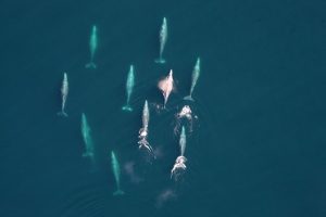
Marine Mammal Monitoring Surveys Using a Hybrid Fixed-Wing UAS
Gathering data on the size of marine wildlife populations and better understanding the risks human activities pose to these populations are core responsibilities of NOAA Southwest Fisheries Science Center / Marine Mammal and Turtle Division. In this study, supported by the UAS Program Office, scientists will be evaluating the use of a fixed-wing UAS platform with vertical take-off and landing (VTOL; Firefly6 Pro, BirdsEyeView Aerobotics, Inc.).
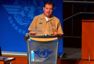
NOAA UAS Program Briefing at Drone Enable Symposium 2019
Captain Philip Hall, Director of the NOAA UAS Program Office in OAR, recently was invited to speak at this year's 3rd Drone Enable Symposium, hosted by the International Civil Aviation Organization (ICAO) at their headquarters in Montreal, Canada on November 12-14, 2019.
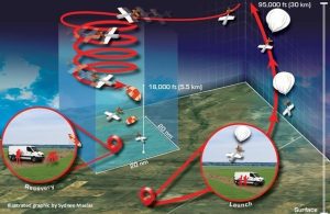
First Test Flights of the High-altitude Operational Return Unmanned System (HORUS) for AirCore
AirCores are routinely launched near Boulder, Colorado using a 6.6-pound balloon with a parachute-based recovery. However, similar to routine weather balloon launches, the recovery of the AirCore and accompanying scientific instrumentation is not always easy. AirCore recovery sites can be nearly 80 kilometers (50 miles) away from the launch site. Recovery sites depend on local winds and are limited to vehicle-accessible locations with few trees, lakes, and housing or commercial development. To increase options for AirCore sampling locations, NOAA/GMD is teaming up with UAS designers at Arizona State University and developers at Delta Zee Solutions, LLC to construct the “High-altitude Operational Return Unmanned System” (HORUS).
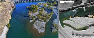
UAS-based Mapping of Riverine Habitats to Inform Management of Endangered Chinook Salmon
River systems provide the physical template for aquatic organisms, including endangered salmonids, and characterizing riverine habitat structure is crucial for species management and conservation. Traditionally, salmon habitat data has been collected over short river segments using ground survey methods, but there is a need to characterize habitat in high resolution at larger spatial scales. Advances in remote sensing from manned aircraft have greatly improved the ability for habitat mapping at larger scales but these approaches may not capture fine-scale habitat features. Now scientists at NOAA and the USGS are working to determine if imagery collected from unmanned aircraft systems (UAS) can be used to help provide quantitative habitat data at ecologically-relevant scales.
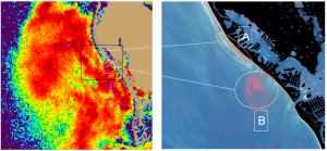
Rapid Detection of Harmful Algal Blooms (HABs) in Waters Nearshore Using sUAS
Several algal blooms around the U.S. produce biotoxins that pose significant risks to human health and marine life. In recent years, these harmful algal blooms (HABs) have caused unprecedented impacts on coastal communities and the tourism, recreation and fishing businesses that support them. In Florida, for example, a recent (2017-2018) “red tide” lasted more than a year and ultimately impacted most of the Florida coast line, creating devastating impacts for fishermen, tourism, and local (beachside) businesses.
Using sUAS (small Unmanned Aircraft Systems) deployed with HAB sensors, we are working to develop and demonstrate a rapid, cost-effective response capability in order to more quickly and accurately know the location of bloom patches.
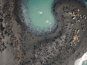
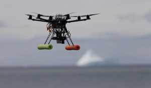
Developing a UAS-Based Approach for Surveying Northern Fur Seals in Alaska
The northern fur seal population in the Pribilof Islands, Alaska has experienced drastic declines. In 2018, St. Paul Island fur seals reached the lowest pup production levels since 1915, while pup abundance in the Pribilof Islands has declined 50 percent since 1998. It is imperative that NOAA Fisheries continue to monitor and document this decline to identify potential threats to recovery and inform management decisions. Currently, population estimates are derived from biennial pup abundance surveys and are conducted on the ground, requiring the participation of more than 20 researchers and support staff for up to 21 days. This method is costly, labor intensive, and involves disturbing the entire population of fur seals on both islands—an estimated 100,000 pups and many more adults and juveniles.
In partnership with the UAS Program Office, NOAA Alaska Fisheries Science Center’s Marine Mammal Laboratory (MML) is working towards developing a survey approach using unmanned aircraft systems (UAS).
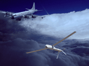
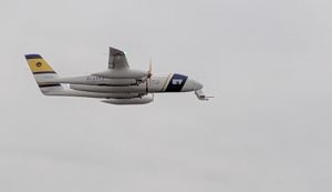
Small Unmanned Aircraft Systems Research and Operations in Tropical Cyclones (sUAS-ROTC)
In recent years, an increasing number of hurricanes have impacted the United States with devastating results, and many experts expect this trend to continue in the years ahead. In the wake of powerful recent Hurricanes Sandy (2012), Harvey (2017), Irma (2017) Maria (2017) and Michael (2018), NOAA is working to provide improved and highly accurate hurricane-related forecasts over a longer time window prior to landfall. NOAA therefore has taken on the challenge to develop a program that will require applying the best science and technology available to improve hurricane prediction without placing NOAA personnel at increased risk. Unmanned Aircraft Systems (UAS) are an emerging technology in the civil and research arena capable of responding to this need.
NOAA is testing and developing three small UAS platforms with the ultimate goal of flying them into the boundary layer environment — i.e. where the hurricane meets the surface of the ocean — of mature hurricanes. The first effort is the OAR-funded project with AREA-I Inc., while the other two of these efforts (with Black Swift Industries and Barron Associates) are being funded through NOAA’s Small Business Innovation Research (SBIR) Program.

NOAA Provides Forecasts for World’s Largest Balloon Festival using Unmanned Aircraft Systems (UAS)
The Albuquerque International Balloon Fiesta is an annual hot air balloon festival that takes place in Albuquerque, New Mexico, over the course of nine days in early October. The event attracts over 500 hot air balloons and over 800,000 attendees each year, making it the largest balloon festival in the world. The 2019 Fiesta is scheduled from October 5-13. During this time, the NOAA Air Resources Lab, UAS Program Office, National Weather Service, and Aircraft Operations Center UAS Section are partnering to provide forecasts for the balloon pilots using a small UAS.
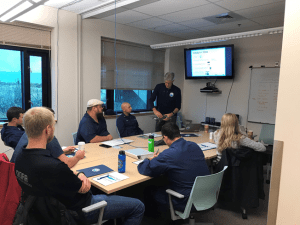
Drone Training for NOAA Shipboard Operation
The National Geodetic Survey Remote Sensing Division and Office of Coast survey, recently trained seven NOAA ship officers and Navigation Response Team members on drone operations at the NOAA Marine Operations Center in Newport, OR. The successful two-day training included classroom instruction and hands-on flights focused on vessel-based research and mapping missions.
Using Drones to Help Improve Weather Forecasts
Small Unmanned Aerial Systems (sUAS), commonly referred to as drones, are becoming widely used for many different applications. One of these applications is to make measurements of the lowest layer of the Earth’s atmosphere in what scientists refer to as the boundary layer. Scientists are now using drones to gather critical information on how temperature, moisture, and wind evolve within the boundary layer under different weather conditions. Doing this helps scientists to better understand the atmosphere, ultimately leading to improvements in weather forecast models used by NOAA’s National Weather Service.