
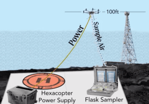
NOAA Global Monitoring Laboratory Development of a UAS “Virtual Tower” for Gas and Ozone Measurements
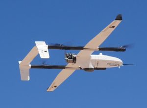
Scientists from NOAA’s Global Monitoring Laboratory (GML) have undertaken novel development of an uncrewed aircraft system (UAS) “hexacopter” that will enable the lab to not only recommence a long-standing mission that was recently forced to halt, but paves the way toward enhanced operations in the future. The composition of Earth’s atmosphere is rapidly changing due to anthropogenic releases of carbon dioxide (CO2) and methane (CH4), which are powerful greenhouse gasses driving global warming. Also, human-made chemicals such as CFC-11 and CFC-12 (refrigerants) are destroying the ozone layer that filters out ultraviolet (UV) radiation. These CFCs and their counterparts destroy enough of the protective stratospheric ozone layer to produce the Antarctic “Ozone Hole”.
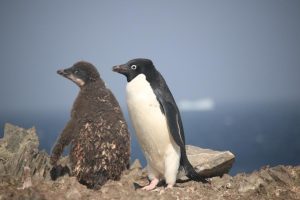
First Beyond Visual Line of Sight (BVLOS) UAS Mission to Map and Count Penguins in Antarctica
A key mission of the Antarctic Ecosystem Research Division (AERD) at NOAA Fisheries’ Southwest Fisheries Science Center (SWFSC) is to develop an understanding of how an international krill fishery operating in Antarctic waters may impact other Antarctic wildlife that consume the main target of this fishery: Antarctic krill (Euphausia superba). Three species of brush-tailed penguins (Pygocelis spp.) nesting in the South Shetland Islands off the Antarctic Peninsula primarily or exclusively consume Antarctic krill. Over the last three decades AERD scientists have monitored the number of penguin chicks raised each year by Adelie (Pygocelis adeliae), Gentoo (Pygocelis papua), and Chinstrap (Pygocelis antarcticus) penguin as one important indicator of how these populations are responding to natural variability and to the impacts of the krill fishery.
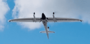
During this project Dr. Trevor Joyce, a contractor affiliated with the SWFSC’s Marine Mammal and Turtle Division, and Dr. Jefferson Hinke from AERD flew a series of Uncrewed Aerial Systems (UAS) missions at AERD’s Copacabana Field Camp on King George Island, Antarctica (62.178°S, 58.446°W) using the FireFly6 Pro fixed-wing vertical take-off and landing (VTOL) UAS. The purpose of these flights was to collect very high-resolution aerial images (0.7-1.2 cm ground sampling resolution) of the penguin colonies in order to count the number of penguin chicks produced in the current breeding season.
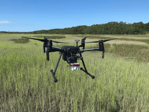
NOAA and Duke University Examine UAS-based Approaches for Coastal Wetland Monitoring
Project team: NOAA National Centers for Coastal Ocean Science (NCCOS), Duke University Marine Robotics Laboratory and Remote Sensing Laboratory, North Carolina National Estuarine Research Reserve (NERR) and North Inlet-Winyah Bay NERR.
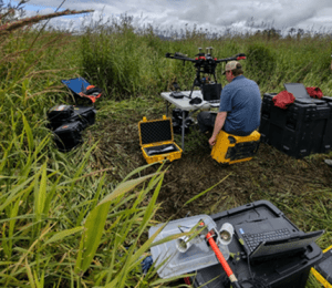
The core mission of NOAA’s National Ocean Service (NOS) includes stewardship of sensitive coastal habitats like those of the National Estuarine Research Reserve System (NERRS), a collection of 29 sites nationwide where NOS and States partner to promote research, education, and preservation of estuarine ecosystems. Unmanned Aerial Systems (UAS) can improve tidal wetland monitoring by providing high spatial resolution and coverage, with customizable sensors, at user-defined times.
This NOS National Centers for Coastal Ocean Science (NCCOS) research project, supported by the NOAA Uncrewed Systems Research Transition Office (UxSRTO), develops methods for the incorporation of Uncrewed Aircraft Systems (UAS) to expand routine wetland monitoring programs like those conducted by the National Estuarine Research Reserve System (NERRS).
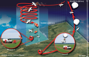
NOAA GML Scientists Successfully Test the “High-Altitude Operational Returning Uncrewed System” Glider with AirCore Science Package to 75,000 feet MSL
Recent flight testing of the “High-altitude Operational Returning Uncrewed System” (HORUS) at NASA’s Armstrong Flight Research Center and Edwards Air Force Base, California between May 13-25, 2021 marks a huge success within NOAA. Scientists from

NOAA PSL and L3Harris Complete miniFlux Payload Integration and Flight Tests
With funding and logistical support from the NOAA Oceanic and Atmospheric Research (OAR) Uncrewed Systems Research Transition Office (UxSRTO), in addition to the NOAA Pacific Marine Environmental Laboratory (PMEL) Clear and Cloudy Sky payloads, the NOAA OAR Physical Sciences Laboratory (PSL), together with partners at the Cooperative Institute for Research in Environmental Sciences (CIRES) and Integrated Remote and In Situ Sensing (IRISS) program at the University of Colorado Boulder developed the miniFlux sensor suite for operation on the L3Harris Latitude Fixed Wing Vertical Takeoff and Landing (VTOL) Rotator (FVR-55). miniFlux is a collection of complementary systems and sensors selected to provide robust and accurate measurements of atmospheric thermodynamic and kinematic states. miniFlux carries sensors to make redundant measurements of temperature, humidity, and pressure, in addition to nadir and zenith thermal IR temperatures and sensors to provide a three dimensional wind measurement. In combination, these measurements, combined with accurate inertial position and orientation measurements collected by the miniFlux system, enable for estimation of atmospheric energy transfer conditions.
On May 6, 2021 L3Harris and PSL successfully completed payload integration and flight testing at the Florence, AZ test flight area. The miniFlux was mounted on the wing of the FVR-55.
Final engineering checkout is planned with L3Harris Latitude FVR-55 and NOAA PMEL and PSL payloads on the Commercial 96' vessel TowBoatU.S. Richard L. Becker,
NOAA PMEL and L3Harris Complete Cloudy Sky and Clear Sky Payload Integration and Flight Tests
As a continuation of the research, the NOAA Oceanic and Atmospheric Research (OAR) UxS Research Transition Office awarded L3Harris a Phase III follow-on contract for the continued development of the FVR-55. This contract is to support shipboard operations and scientific payload integration on the FVR-55. Flight tests were completed on February 17, 2020 off the M/V Richard L. Becker out of Fort Lauderdale, FL to demonstrate autonomous takeoff and recovery from a moving vessel at-sea. L3Harris completed all objectives and demonstrated fully autonomous flight using Hybrid Quadrotor (HQ) technology from a moving ship with limited deck space.
On March 22-26, 2021 the NOAA PMEL team joined the L3Harris staff at their facility in Tucson, AZ to complete bench and initial flight testing (Florence, AZ test flight area) of the Cloudy and Clear Sky payloads to verify the payloads functionality. The two payloads measure the aerosol and cloud properties required for the observation of aerosol direct radiative effects (Clear Sky payload) and impacts of aerosols on clouds (Cloudy Sky Payload).
National Severe Storms Laboratory High-Wind Damage Assessment Following Severe Weather Events
National Severe Storms Laboratory (NSSL) / Cooperative Institute for Mesoscale Meteorological Studies (CIMMS) will document high-wind damage immediately following high-wind events in the Southeast US from February 15th to April 30th, 2021. UAS platforms will be deployed to collect high-resolution imagery of storm damage affected areas:
1) To better characterize high-wind damage to vegetation and in rural areas.
2) To better link signatures from remote sensing platforms (radars and satellites) to impacts at the ground to improve understanding of severe storm-level dynamics.
To learn more about NSSL UAS operations and objectives refer to the flowing link: https://inside.nssl.noaa.gov/uas/
Disclosure: The proposed UAS operations would not involve any intentional collection of Personally Identifiable Information (PII). Any accidental or “inadvertent” PII collection would be obscured or deleted through irreversible pixel blurring, pixel blocking using overlaid shapes/symbols, and permanent cropping. For more information on Privacy refer to the following: Privacy Act of 1974 – 5 USC 552a. Additionally, NSSL/CIMMS would not intentionally fly over individuals. Although consent may not be obtained, there is minimal impact to individuals because NSSL/CIMMS would not retain any PII through the obscuration methods detailed above.

NOAA’s Global Monitoring Laboratory Gears up for Testing of High-Altitude sUAS and Full Scientific Payload at NASA’s Armstrong Flight Research Center and Edwards Air Force Base
NOAA’s Global Monitoring Laboratory (GML) has transformed high-altitude greenhouse gas sampling in the past decade with the AirCore balloon-borne sampler that collects air from the stratosphere (~95,000 ft Mean Sea Level (MSL) to the earth’s surface, analogous to an ice “core.” A typical AirCore flight is facilitated by a balloon-based ascent to 95,000 ft MSL, followed by balloon cutaway and parachute recovery to the ground. Because the AirCore and its accompanying scientific payload – facilitated by small balloon technology – enables atmospheric sampling at altitudes higher than most aircraft measurement systems, this novel technique is an effective method for sampling trace gases such as carbon dioxide, methane, carbon monoxide and other meteorological state variables (temperature, relative humidity, pressure) in more than 98 percent of the earth’s atmosphere at a fraction of the cost of aircraft systems.
Advances in Monitoring Restoration of Juvenile Salmon Habitat with Drones
Juvenile Pacific salmon rely on functioning wetlands for food and shelter as they migrate to the sea. In the Pacific Northwest, most wetland habitats have been lost or severely impacted, necessitating widespread restoration programs enacted to improve connectivity between water systems and reestablish native vegetation. Programs may include varied ecological engineering solutions, but all require monitoring to assess effectiveness. Until recently, assessments have lacked spatial and temporal resolution and have been time-consuming and expensive.
With funding and logistical support from the NOAA Oceanic and Atmospheric Research (OAR) Uncrewed Systems Research Transition Office (USRTO), scientists from the National Marine Fisheries Service (NMFS) have developed integrated remote sensing protocols using Uncrewed Aerial Vehicles (drones), advanced instrumentation, and image analysis methods that together facilitate a broad habitat assessment capability.