
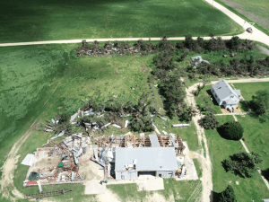
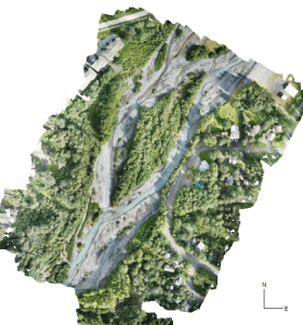
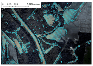
UAS Characterization of High Wind Damage to Vegetation and Rural Area Assessments
Damage assessments provide insight into the occurrence, intensity, and distribution of tornadoes and other high-wind events. Current ground survey and satellite assessments, however, are restricted by available resources (e.g., personnel, time, and cost), accessibility, technological limitations, and damage indicators used to infer storm intensity. These assessments can be especially challenging in rural areas because storm damage is frequently underestimated due to the inability to detect vegetation stress, limited vegetation damage indicators, and low population density. In these sparsely populated areas, storm damage is often underreported and consequently affects severe storm climatology and our understanding of risk. Underestimating this risk can have serious implications on hazard monitoring as well as disaster preparedness and recovery in rural areas. With the help of the NOAA Oceanic and Atmospheric Research (OAR) Uncrewed Systems Research Transition Office (USRTO), scientists from the NOAA National Severe Storms Laboratory in collaboration with the Cooperative Institute for Mesoscale Meteorological Studies are working on developing an uncrewed aircraft system (UAS)-based approach to better characterize high-wind damage to vegetation and in rural areas to improve disaster response and recovery.
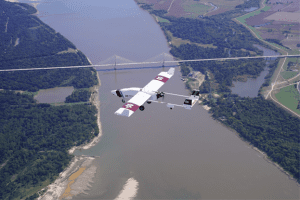
UAS Missions Supporting Flood Forecasting Following Hurricane Delta Landfall
The NOAA OAR UAS Program, in cooperation with the National Weather Service River Forecast Centers (NWS RFCs) in the Southern Region and the Northern Gulf Institute (NGI; a NOAA Cooperative Institute), established a study several years ago to determine the cost and contributions of UAS-collected data toward improving forecasts and warnings of significant flood events. While the impacts of severe flooding are not isolated to this area alone, according to NOAA NCEI’s 2020 report, U.S. Billion-Dollar Weather and Climate Disasters, “The highest frequency of inland flood (i.e., non-tropical) events often occur in states adjacent to large rivers or the Gulf of Mexico, which is a warm source of moisture to fuel rainstorms”. The need for accurate, rapidly obtainable data in this region is all the more emphasized when this fact is combined with other known impacts from land-falling tropical cyclones each hurricane season.
In October 2020, NGI added to the list of previous successful UAS deployments in support of this study, as the group was once again called into action by the regional NWS RFC to collect aerial flood image data after Hurricane Delta made landfall in Louisiana and passed through Mississippi.
NOAA GLERL Great Lakes Cyanobacteria Harmful Algal Bloom Monitoring
While the pandemic has presented challenges to field operations these past few months, NOAA Great Lakes Environmental Research Laboratory (NOAA GLERL) has worked to continue collecting data in a safe manner. Data provides critical monitoring of cyanobacteria harmful algal blooms (cyanoHABs) in the western basin of Lake Erie. Crewed aircraft flyover operations, while delayed, continued to provide robust data sets beneath clouds and nearshore. In order to operate comfortably, crewed flyover operations are performed 3500-6500 feet with possible interference from cloud cover that is often forming as low as 1800 feet above the western basin. Next summer, with the support of UASPO funding, GLERL will operate a multi-rotor Uncrewed Aircraft System (UAS) to fly beneath the clouds and provide unprecedented imagery of areas close to shore, addressing a key information gap. The combination of these data sets will support the NOAA Lake Erie HAB Forecast.
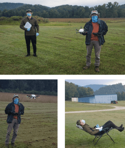
NOAA Resumes Routine Vertical Profiling Using Small Uncrewed Aircraft Systems to Benefit Weather Forecasts
Since 2015, the NOAA Air Resources Laboratory (ARL) Atmospheric Turbulence and Diffusion Division (ATDD) in Oak Ridge, Tennessee has been using small Uncrewed Aircraft Systems (sUAS) to better understand processes occurring in the lowest few hundred feet of the atmosphere. Much of this work has been conducted during targeted field studies, in which scientists and engineers from ATDD have performed sUAS flights to complement measurements obtained from other weather observing platforms (surface weather monitoring instruments, weather balloons, and radars for example) deployed by ATDD and its collaborators from other NOAA laboratories and universities.
NWS’s Alaska-Pacific River Forecast Center Builds a UAS Program
The link below provides a video that highlights early successes with UAS applications by the Alaska-Pacific River Forecast Center (APRFC). The APRFC is funded by the UAS Program to look at the feasibility of using small UAS to map flood inundation, as well as for inspecting towers with meteorological instruments. Alaska’s communities face flood risk from river ice jams, glacial dammed lake outbursts, and rainfall-driven events. So far, UAS show strong potential for helping improve flood forecasts and other decision support products from the National Weather Service.
https://uas.noaa.gov/portals/5/Videos/Summer_APRFC_Missions_Film_1.mp4
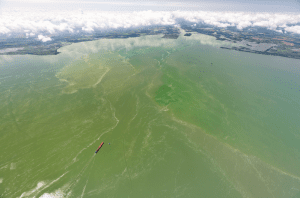
NOAA GLERL Great Lakes UAS Initiative for Harmful Algal Bloom
The NOAA Unmanned Aircraft Systems (UAS) Program Office empowers researchers and engineers to use drones to aid in key research projects and quickly respond to weather, climate and other environmental events. Combining powerful UAS platforms and smaller sensors, it is feasible to routinely and rapidly detect events such as oil spills and cyanobacteria harmful algal blooms (cyanoHABs).
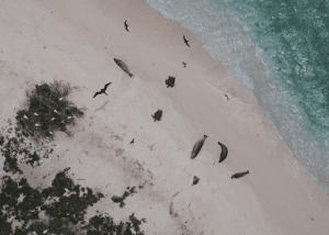
Evaluating New UAS Platform to Conduct High Priority Protected Species Research in Hawaii
Hawksbill sea turtles (Eretmochelys imbricata) and Hawaiian monk seals (Neomonachus schauinslandi) are listed as endangered under the Endangered Species Act, and green sea turtles (Chelonia mydas) are listed as threatened. All three species use beaches throughout the Hawaiian Archipelago that are remote and difficult to access. This has precluded comprehensive investigations of these species by the Pacific Islands Fisheries Science Center (PIFSC) Protected Species Division (PSD) in remote areas which has inhibited holistic population evaluations of these priority species.
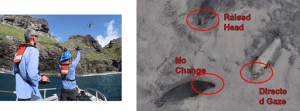
Assessment of Disturbance to Hawaiian Monk Seals and Birds in the Northwestern Hawaiian Islands by the APH-22 Hexacopter
In an effort to determine whether use of a UAS APH-22 hexacopter would cause disturbance to endangered Hawaiian monk seals or seabirds, the team at the Pacific Islands Fisheries Science Center’s Hawaiian Monk Seal Research Program embarked on an exploratory study in the Northwestern Hawaiian Islands (NWHI).
NGI Publishes Research on Use of UAS to Identify and Analyze Flood Impacts
With funding provided by the NOAA UAS Program Office in OAR through the “SHOUT4Rivers” project, Dr. Robert Moorhead (Director of NOAA’s Northern Gulf Institute, NGI, and principal investigator) and his team have been working for the past couple of years to develop and test plans to deploy large UAS to collect aerial imagery of flood-impacted regions in response to needs expressed by multiple NWS River Forecast Centers (RFCs).