
National Severe Storms Laboratory High-Wind Damage Assessment Following Severe Weather Events
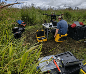
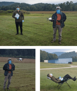
National Severe Storms Laboratory (NSSL) / Cooperative Institute for Mesoscale Meteorological Studies (CIMMS) will document high-wind damage immediately following high-wind events in the Southeast US from February 15th to April 30th, 2021. UAS platforms will be deployed to collect high-resolution imagery of storm damage affected areas:
1) To better characterize high-wind damage to vegetation and in rural areas.
2) To better link signatures from remote sensing platforms (radars and satellites) to impacts at the ground to improve understanding of severe storm-level dynamics.
To learn more about NSSL UAS operations and objectives refer to the flowing link: https://inside.nssl.noaa.gov/uas/
Disclosure: The proposed UAS operations would not involve any intentional collection of Personally Identifiable Information (PII). Any accidental or “inadvertent” PII collection would be obscured or deleted through irreversible pixel blurring, pixel blocking using overlaid shapes/symbols, and permanent cropping. For more information on Privacy refer to the following: Privacy Act of 1974 – 5 USC 552a. Additionally, NSSL/CIMMS would not intentionally fly over individuals. Although consent may not be obtained, there is minimal impact to individuals because NSSL/CIMMS would not retain any PII through the obscuration methods detailed above.

NOAA’s Global Monitoring Laboratory Gears up for Testing of High-Altitude sUAS and Full Scientific Payload at NASA’s Armstrong Flight Research Center and Edwards Air Force Base
NOAA’s Global Monitoring Laboratory (GML) has transformed high-altitude greenhouse gas sampling in the past decade with the AirCore balloon-borne sampler that collects air from the stratosphere (~95,000 ft Mean Sea Level (MSL) to the earth’s surface, analogous to an ice “core.” A typical AirCore flight is facilitated by a balloon-based ascent to 95,000 ft MSL, followed by balloon cutaway and parachute recovery to the ground. Because the AirCore and its accompanying scientific payload – facilitated by small balloon technology – enables atmospheric sampling at altitudes higher than most aircraft measurement systems, this novel technique is an effective method for sampling trace gases such as carbon dioxide, methane, carbon monoxide and other meteorological state variables (temperature, relative humidity, pressure) in more than 98 percent of the earth’s atmosphere at a fraction of the cost of aircraft systems.
Advances in Monitoring Restoration of Juvenile Salmon Habitat with Drones
Juvenile Pacific salmon rely on functioning wetlands for food and shelter as they migrate to the sea. In the Pacific Northwest, most wetland habitats have been lost or severely impacted, necessitating widespread restoration programs enacted to improve connectivity between water systems and reestablish native vegetation. Programs may include varied ecological engineering solutions, but all require monitoring to assess effectiveness. Until recently, assessments have lacked spatial and temporal resolution and have been time-consuming and expensive.
With funding and logistical support from the NOAA Oceanic and Atmospheric Research (OAR) Uncrewed Systems Research Transition Office (USRTO), scientists from the National Marine Fisheries Service (NMFS) have developed integrated remote sensing protocols using Uncrewed Aerial Vehicles (drones), advanced instrumentation, and image analysis methods that together facilitate a broad habitat assessment capability.
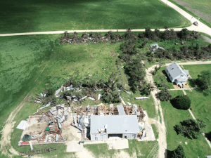
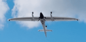
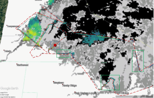
UAS Characterization of High Wind Damage to Vegetation and Rural Area Assessments
Damage assessments provide insight into the occurrence, intensity, and distribution of tornadoes and other high-wind events. Current ground survey and satellite assessments, however, are restricted by available resources (e.g., personnel, time, and cost), accessibility, technological limitations, and damage indicators used to infer storm intensity. These assessments can be especially challenging in rural areas because storm damage is frequently underestimated due to the inability to detect vegetation stress, limited vegetation damage indicators, and low population density. In these sparsely populated areas, storm damage is often underreported and consequently affects severe storm climatology and our understanding of risk. Underestimating this risk can have serious implications on hazard monitoring as well as disaster preparedness and recovery in rural areas. With the help of the NOAA Oceanic and Atmospheric Research (OAR) Uncrewed Systems Research Transition Office (USRTO), scientists from the NOAA National Severe Storms Laboratory in collaboration with the Cooperative Institute for Mesoscale Meteorological Studies are working on developing an uncrewed aircraft system (UAS)-based approach to better characterize high-wind damage to vegetation and in rural areas to improve disaster response and recovery.
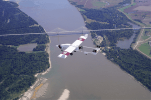
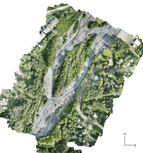
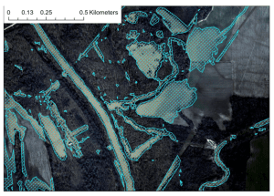
UAS Missions Supporting Flood Forecasting Following Hurricane Delta Landfall
The NOAA OAR UAS Program, in cooperation with the National Weather Service River Forecast Centers (NWS RFCs) in the Southern Region and the Northern Gulf Institute (NGI; a NOAA Cooperative Institute), established a study several years ago to determine the cost and contributions of UAS-collected data toward improving forecasts and warnings of significant flood events. While the impacts of severe flooding are not isolated to this area alone, according to NOAA NCEI’s 2020 report, U.S. Billion-Dollar Weather and Climate Disasters, “The highest frequency of inland flood (i.e., non-tropical) events often occur in states adjacent to large rivers or the Gulf of Mexico, which is a warm source of moisture to fuel rainstorms”. The need for accurate, rapidly obtainable data in this region is all the more emphasized when this fact is combined with other known impacts from land-falling tropical cyclones each hurricane season.
In October 2020, NGI added to the list of previous successful UAS deployments in support of this study, as the group was once again called into action by the regional NWS RFC to collect aerial flood image data after Hurricane Delta made landfall in Louisiana and passed through Mississippi.
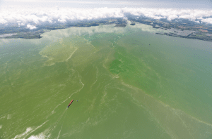
NOAA GLERL Great Lakes Cyanobacteria Harmful Algal Bloom Monitoring
While the pandemic has presented challenges to field operations these past few months, NOAA Great Lakes Environmental Research Laboratory (NOAA GLERL) has worked to continue collecting data in a safe manner. Data provides critical monitoring of cyanobacteria harmful algal blooms (cyanoHABs) in the western basin of Lake Erie. Crewed aircraft flyover operations, while delayed, continued to provide robust data sets beneath clouds and nearshore. In order to operate comfortably, crewed flyover operations are performed 3500-6500 feet with possible interference from cloud cover that is often forming as low as 1800 feet above the western basin. Next summer, with the support of UASPO funding, GLERL will operate a multi-rotor Uncrewed Aircraft System (UAS) to fly beneath the clouds and provide unprecedented imagery of areas close to shore, addressing a key information gap. The combination of these data sets will support the NOAA Lake Erie HAB Forecast.
NOAA Resumes Routine Vertical Profiling Using Small Uncrewed Aircraft Systems to Benefit Weather Forecasts
Since 2015, the NOAA Air Resources Laboratory (ARL) Atmospheric Turbulence and Diffusion Division (ATDD) in Oak Ridge, Tennessee has been using small Uncrewed Aircraft Systems (sUAS) to better understand processes occurring in the lowest few hundred feet of the atmosphere. Much of this work has been conducted during targeted field studies, in which scientists and engineers from ATDD have performed sUAS flights to complement measurements obtained from other weather observing platforms (surface weather monitoring instruments, weather balloons, and radars for example) deployed by ATDD and its collaborators from other NOAA laboratories and universities.
NWS’s Alaska-Pacific River Forecast Center Builds a UAS Program
The link below provides a video that highlights early successes with UAS applications by the Alaska-Pacific River Forecast Center (APRFC). The APRFC is funded by the UAS Program to look at the feasibility of using small UAS to map flood inundation, as well as for inspecting towers with meteorological instruments. Alaska’s communities face flood risk from river ice jams, glacial dammed lake outbursts, and rainfall-driven events. So far, UAS show strong potential for helping improve flood forecasts and other decision support products from the National Weather Service.
https://uas.noaa.gov/portals/5/Videos/Summer_APRFC_Missions_Film_1.mp4
NOAA GLERL Great Lakes UAS Initiative for Harmful Algal Bloom
The NOAA Unmanned Aircraft Systems (UAS) Program Office empowers researchers and engineers to use drones to aid in key research projects and quickly respond to weather, climate and other environmental events. Combining powerful UAS platforms and smaller sensors, it is feasible to routinely and rapidly detect events such as oil spills and cyanobacteria harmful algal blooms (cyanoHABs).
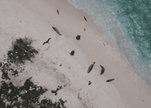
Evaluating New UAS Platform to Conduct High Priority Protected Species Research in Hawaii
Hawksbill sea turtles (Eretmochelys imbricata) and Hawaiian monk seals (Neomonachus schauinslandi) are listed as endangered under the Endangered Species Act, and green sea turtles (Chelonia mydas) are listed as threatened. All three species use beaches throughout the Hawaiian Archipelago that are remote and difficult to access. This has precluded comprehensive investigations of these species by the Pacific Islands Fisheries Science Center (PIFSC) Protected Species Division (PSD) in remote areas which has inhibited holistic population evaluations of these priority species.
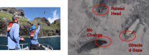
Assessment of Disturbance to Hawaiian Monk Seals and Birds in the Northwestern Hawaiian Islands by the APH-22 Hexacopter
In an effort to determine whether use of a UAS APH-22 hexacopter would cause disturbance to endangered Hawaiian monk seals or seabirds, the team at the Pacific Islands Fisheries Science Center’s Hawaiian Monk Seal Research Program embarked on an exploratory study in the Northwestern Hawaiian Islands (NWHI).
NGI Publishes Research on Use of UAS to Identify and Analyze Flood Impacts
With funding provided by the NOAA UAS Program Office in OAR through the “SHOUT4Rivers” project, Dr. Robert Moorhead (Director of NOAA’s Northern Gulf Institute, NGI, and principal investigator) and his team have been working for the past couple of years to develop and test plans to deploy large UAS to collect aerial imagery of flood-impacted regions in response to needs expressed by multiple NWS River Forecast Centers (RFCs).
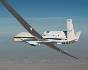
NOAA’S Sensing Hazards with Operational Unmanned Technology (SHOUT) Experiment: Observations and Forecast Impacts
During 2015 and 2016, NOAA conducted three field campaigns using the NASA Global Hawk autonomous aircraft outfitted with GPS dropwindsondes and remote sensors. The Sensing Hazards with Operational Unmanned Technology (SHOUT) project evaluated the potential ability of this high-altitude aircraft to collect novel observations to improve forecasts of high-impact weather events including hurricanes. The experiment also examined the effectiveness of employing new technology of this type. A new article to be published in the Bulletin of the American Meteorological Society, led by ESRL PSD with multiple NOAA and joint institute co-authors, provides a an overview of SHOUT and summarize the various missions flown over the two-year campaign, the observations collected and their application, and the results of a diverse set of studies evaluating the impact of the data on multiple operational forecast systems.
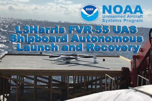
L3Harris Successfully Completes Autonomous Shipboard Launch and Recovery of FVR-55 Unmanned Aircraft
On February 17, 2020, flight tests were conducted by L3Harris on the M/V Richard L. Becker off Fort Lauderdale, FL to demonstrate autonomous takeoff and recovery from a moving vessel at-sea. L3Harris completed all objectives and demonstrated fully autonomous flight using Hybrid Quadrotor (HQ) technology from a moving ship with limited deck space. The FVR-55 took off from the ship vertically, switched to fixed wing flight, and returned and landed vertically on the ship autonomously (no external pilot control inputs required).
Deployment and Operation of the RAAVEN small Unmanned Aerial System (sUAS) in Support of NOAA Science during ATOMIC
Supported with UAS Program Office funding, a team from the University of Colorado Boulder will deploy the RAAVEN sUAS from Barbados between 19 January and 17 February 2020. Launch and retrieval will occur from the shore at a field and the adjacent beach in Morgan Lewis, Barbados. RAAVEN miniFlux measurements can directly contribute to advancing our scientific understanding relevant to NOAA forecasting efforts across weather and climate scales. Specifically, information on the vertical distribution of