Official websites use .gov
A .gov website belongs to an official government organization in the United States.

Secure .gov websites use HTTPS
A lock ( ) or https:// means you’ve safely connected to the .gov website. Share sensitive information only on official, secure websites.

December 2018

Development of an Autonomous Payload for Detection of Seals and Polar Bears on Sea Ice

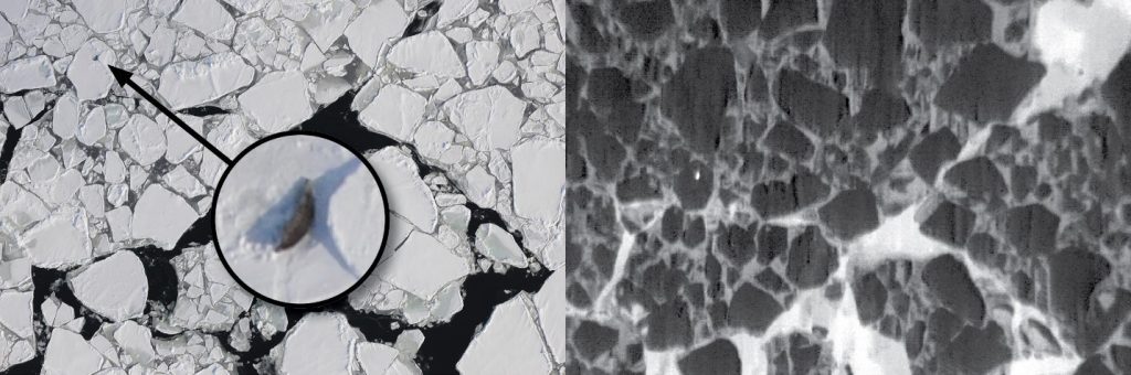
Polar bears and Ice-associated seals (bearded, ringed, spotted, and ribbon seals) are key components of Arctic marine ecosystems and are important resources for coastal Alaska Native communities. Reliable abundance estimates for ice seals are needed for developing sound management decisions under the Marine Mammal Protection Act and extinction risk assessments under the Endangered Species Act. The animals’ broad and patchy geographic distributions and rapidly changing sea ice habitat make these species particularly challenging to study.

An autonomous payload is required to integrate UAS into surveys of ice-associated mammals, in order to improve the efficiency and human safety in gathering essential data for NOAA stewardship. Moving from occupied aircraft to long-range UAS operations will require an efficient and “smart” payload to collect images needed for abundance estimation and habitat analysis while providing situational awareness to the pilot in command.

The Alaska Fisheries Science Center’s Marine Mammal Lab is developing a system that can run advanced machine learning algorithms on-board the aircraft to process multispectral imagery in real time, minimizing the collection of extraneous imagery that requires burdensome data storage, management, and processing.  Algorithm development is utilizing a neural network approach known as YOLO, which processes imagery at a rate of 60-100 frames per second.  Over 1.8 million color and thermal images are being used to train YOLO to detect animals on the sea ice and classify detections to species. This algorithm will be tested in-flight during April 2019.

Development of an Autonomous Payload for Detection of Seals and Polar Bears on Sea Ice Read More »

Nighttime Fire Observations eXperiment (NightFOX)

Biomass burning produces major impacts on local and regional air quality which potentially plays an interactive role in climate change. A capable small, fixed-wing unmanned aircraft system (sUAS) can serve as an ideal platform for measurements of biomass burning emissions, plume distribution, fire extent and perimeter, and supporting meteorological data, especially at night when manned aircraft typically do not operate. The NOAA UASPO-funded Nighttime Fire Observations eXperiment (NightFOX) project aims to develop and deploy a sUAS observation system utilizing two modular and easily exchangeable payloads. One payload will provide in situ measurements of CO2, CO and fine- and coarse-mode aerosol size distributions in biomass burning plumes for characterization of fire combustion efficiency and emissions. A filter sampler will collect bulk aerosol samples for off-line composition analysis. The second payload will be flown over the fire to make remote sensing measurements of fire perimeter and fire radiative power using visible and short-, mid-, and long-wavelength IR observations. The multi-spectral remote sensing data will be used to provide sub-pixel information for comparison with satellite fire observations, and along with measured meteorological parameters, will be used to inform, test, and improve the WRF-SFIRE fire-atmosphere model.

Prototype in-situ and remote-sensing instrument payloads have been developed and are operational. Initial test flights with the payloads have recently been conducted. The performance of the prototype payloads has proven satisfactory and new versions are currently under development that will be used for the NIghtFOX operational deployment to study western wildfires next summer during the NOAA/NASA FIREX-AQ mission. Preliminary data processing algorithms for the remote sensing observations have been developed based on test flight results. A nighttime high-altitude FAA COA was obtained and a nighttime flight to an altitude of 2000 ft (0.61 km) was conducted on November 08, 2018, as a stepping stone to the 1 km design altitude for remote sensing operations.

Nighttime Fire Observations eXperiment (NightFOX) Read More »