Official websites use .gov
A .gov website belongs to an official government organization in the United States.

Secure .gov websites use HTTPS
A lock ( ) or https:// means you’ve safely connected to the .gov website. Share sensitive information only on official, secure websites.

October 2020

UAS Missions Supporting Flood Forecasting Following Hurricane Delta Landfall

The NOAA OAR UAS Program, in cooperation with the National Weather Service River Forecast Centers (NWS RFCs) in the Southern Region and the Northern Gulf Institute (NGI; a NOAA Cooperative Institute), established a study several years ago to determine the cost and contributions of UAS-collected data toward improving forecasts and warnings of significant flood events. While the impacts of severe flooding are not isolated to this area alone, according to NOAA NCEI’s 2020 report, U.S. Billion-Dollar Weather and Climate Disasters, “The highest frequency of inland flood (i.e., non-tropical) events often occur in states adjacent to large rivers or the Gulf of Mexico, which is a warm source of moisture to fuel rainstorms”. The need for accurate, rapidly obtainable data in this region is all the more emphasized when this fact is combined with other known impacts from land-falling tropical cyclones each hurricane season. 

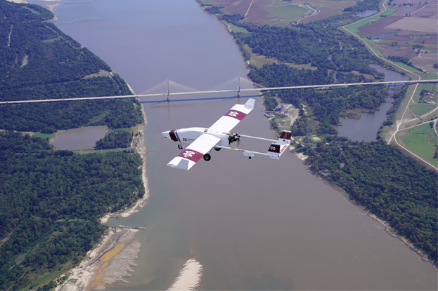
In October 2020, NGI added to the list of previous successful UAS deployments in support of this study, as the group was once again called into action by the regional NWS RFC to collect aerial flood image data after Hurricane Delta made landfall in Louisiana and passed through Mississippi. 

UAS Missions Supporting Flood Forecasting Following Hurricane Delta Landfall Read More »

NOAA GLERL Great Lakes Cyanobacteria Harmful Algal Bloom Monitoring

While the pandemic has presented challenges to field operations these past few months, NOAA Great Lakes Environmental Research Laboratory (NOAA GLERL) has worked to continue collecting data in a safe manner. Data provides critical monitoring of cyanobacteria harmful algal blooms (cyanoHABs) in the western basin of Lake Erie. Crewed aircraft flyover operations, while delayed, continued to provide robust data sets beneath clouds and nearshore. In order to operate comfortably, crewed flyover operations are performed 3500-6500 feet with possible interference from cloud cover that is often forming as low as 1800 feet above the western basin. Next summer, with the support of UASPO funding, GLERL will operate a multi-rotor Uncrewed Aircraft System (UAS) to fly beneath the clouds and provide unprecedented imagery of areas close to shore, addressing a key information gap. The combination of these data sets will support the NOAA Lake Erie HAB Forecast.

NOAA GLERL Great Lakes Cyanobacteria Harmful Algal Bloom Monitoring Read More »

Ed Dumas

NOAA Resumes Routine Vertical Profiling Using Small Uncrewed Aircraft Systems to Benefit Weather Forecasts

Since 2015, the NOAA Air Resources Laboratory (ARL) Atmospheric Turbulence and Diffusion Division (ATDD) in Oak Ridge, Tennessee has been using small Uncrewed Aircraft Systems (sUAS) to better understand processes occurring in the lowest few hundred feet of the atmosphere. Much of this work has been conducted during targeted field studies, in which scientists and engineers from ATDD have performed sUAS flights to complement measurements obtained from other weather observing platforms (surface weather monitoring instruments, weather balloons, and radars for example) deployed by ATDD and its collaborators from other NOAA laboratories and universities. 

NOAA Resumes Routine Vertical Profiling Using Small Uncrewed Aircraft Systems to Benefit Weather Forecasts Read More »