Official websites use .gov
A .gov website belongs to an official government organization in the United States.

Secure .gov websites use HTTPS
A lock ( ) or https:// means you’ve safely connected to the .gov website. Share sensitive information only on official, secure websites.

Ken Vierra

Montreal Protocol Violation and a Hawaiian Lava Flow…Using a Hexacopter to Replace a 100 ft. Sampling Tower

Air samples collected through an air-line supported 100 ft. above ground level on a tower at Cape Kumukahi, Hawaii, showed that a multi-decade long decline in CFC-11, a stratospheric ozone depleting gas controlled by the Montreal Protocol, is stalling. In a paper published in Nature, May 2018, NOAA Global Monitoring Division scientists show this disallowed CFC-11 production is coming from eastern China, 10,000 km upwind of Cape Kumukahi (Figure 1).
During recent eruption access to the Cape Kumukahi tower was destroyed by a 30 ft. high wall of hot lava which also destroyed the road, inundated the area, cut the power line and terminated sampling from the tower (Figure 2). In May 2018 subsequent air samples collected at the surface near the tower site were not of acceptable quality (Figure 3). By way of reference, ozone depleting gas concentrations are measured in parts per trillion (ppt) or better.

To visualize a ppt, here is an analogy. If you have a wall of silver dollars 6 ft. wide by 6 ft. tall, 200 miles long, there will be about one trillion silver dollars in that wall. Take one of those coins out of the wall and scratch it. NOAA Global Monitoring Division scientists will tell you where in that wall the coin came from, and on what side the coin was scratched, 99 times out of a 100. Some CFC-11 measurements require determining concentrations to a 10th of a ppt. Following the above analogy, the wall of silver dollars would be 2,000 miles long but the measurements would still pinpoint the scratched coin’s location, 99 out of 100 times.

In order to reestablish the Cape Kumukahi measurement program with the same sampling parameters as prior to the lava flow, it is necessary to sample air from near to the same location and altitude. A replacement tower may never be built as the cost for road, power line and tower would be in the million $ scale. As a possible replacement a tethered UAS hexacopter system has been developed to accomplish the same sampling parameters, at the same sight at a much reduced cost.

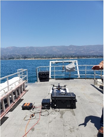
Specifically via UAS Program Office support, the Global Monitoring Division will use a tethered DJI 600M hexacopter to pull up an air sampling line to 100 ft. and hover while flasks are filled with a pump at the surface (Figure 4). The hexacopter will be powered by either batteries or powered by a generator operating on propane. The sampling line weighs 2.5 lbs. whereas the hexacopter can carry 6 lbs. Operations in winds up to 20 mph should be possible. Prior to deployment, the efficacy of the system and any possible contamination issues will be thoroughly vetted at the NIST Table Mesa test facility near Boulder, CO.

The hexacopter and tether system components will arrive in late September 2019 with field testing in November and modifications/sample QA/QC in December 2019. If all goes as planned, deployment to Hawaii will be in January/February 2020 with additional QA/QC and test operations at Cape Kumukahi. Assuming all operator training, safety, logistics QA/QC and permissions are completed, the system should become operational with weekly sampling beginning in March 2020. This resumption of measurements will be timely as China has agreed to comply with the Montreal Protocol immediately (Nature, May 2019). The NOAA Cape Kumukahi measurements will assist in verify the compliance.

This tethered hexacopter system will be relatively cheap for above ground surface sampling, is highly mobile and could be deployed globally and hence facilitating collecting air samples under many different scenarios in a variety of environments.

Montreal Protocol Violation and a Hawaiian Lava Flow…Using a Hexacopter to Replace a 100 ft. Sampling Tower Read More »

Forecast for Harmful Algal Blooms in Lake Erie 2019

The UAS Program Office is supporting Dr. Stumpf, (NOAA/National Centers for Coastal Ocean Science (NCCOS), on a project where the goal is to use sUAS (small Unmanned Aircraft Systems) to deploy harmful algal bloom (HAB) sensors and to develop and demonstrate a rapid, cost-effective response capability in order to more quickly and accurately know the location of bloom patches. Advancing this real-time detection capability would enable states (especially Florida) and counties to more effectively deploy and focus their limited sampling resources. Furthermore, this capability would enhance NOAA’s HAB forecasting capability so as to be able to provide improved warnings to the public, and therein increase public safety and reduce economic impact. This capability, once demonstrated, will be transitioned to states for integration into their HAB monitoring programs. Improved HAB forecasting is identified as an agency priority in the NOAA Next Generation Strategic Plan Objective – Improved coastal water quality supporting human health and coastal ecosystem services and as a Line Office mission goal in NOS Priorities Roadmap, under “Threats to human health and safety from ecological hazards”.

On July 11, 2019 Dr. Richard Stumpf attended a Harmful Algal Bloom (HAB) Workshop (“Forecast for Harmful Algal Blooms in Lake Erie 2019”) hosted by Ohio Sea Grant & Stone Lab. At the workshop, he presented the seasonal forecast for the HAB in western Lake Erie, developed by NOAA and its research partners.  Western Lake Erie will experience a significant harmful algal bloom (HAB) this summer, expected to measure 7.5 on the severity index, but could range between 6 and 9.  An index above 5 indicates blooms having greater impact. The severity index is based on bloom's biomass – the amount of algae – over a sustained period. The largest blooms occurred in 2011, with a severity index of 10, and 2015, at 10.5. Last year’s bloom had a severity index of 3.6, while 2017's was 8.0.

Lake Erie blooms consist of cyanobacteria, also called blue-green algae that are capable of producing the liver toxin microcystin that poses a risk to human and wildlife health. Such blooms may result in higher costs for cities and local governments that need to treat drinking water, prevent people from enjoying fishing, swimming, boating and visiting the shoreline, and harm the region’s vital summer tourism economy. These effects will vary in location and severity due to winds that may concentrate or dissipate the bloom.

“Communities along Lake Erie rely upon clean, healthy water to support their community’s well-being and economic livelihoods,” said Nicole LeBoeuf, acting director of NOAA’s National Ocean Service. “This forecast provides timely and trusted science-based information to water managers and public health officials so they can better anticipate blooms, mitigate impacts and reduce future outbreaks.”

This year, the lake temperature has remained relatively cool due to the higher-than-average rainfall in the region, so the bloom is not expected to start until late July when the water temperature reaches 65 to 70 degrees F. This contrasts with 2018, when exceptionally warm weather at the beginning of June caused an early start. Calm winds in July, especially in western Lake Erie, tend to allow the algal toxins t

Forecast for Harmful Algal Blooms in Lake Erie 2019 Read More »

Testing the Planck Aerosystems "Shearwater" small unmanned aircraft system (sUAS) aboard the NOAA research vessel R/V Shearwater in the Santa Barbara Channel on July 29

Operational Evaluation of Planck Aerosystems “Shearwater” Small Unmanned Aircraft System (sUAS) in the Santa Barbara Channel July 29 – 31, 2019

Channel Islands National Marine Sanctuary CINMS) / Collaborative Center for Unmanned Technologies (CCUT) staff supported the field testing of a Planck Aerosystems “Shearwater” sUAS aboard the NOAA Research Vessel Shearwater (Figure: 1) and the salvage vessel Danny C (Figure: 2). in the Santa Barbara Channel July 29 – 31, 2019. The project was funded by the NOAA OAR UAS Program Office. In participation were LTJG Nicole Chappelle from the NOAA OMAO Aircraft Operations Center Co-PI Alan Jaeger from the US Navy and project PI Todd Jacobs of ONMS CCUT.  The goals of the project are to evaluate the Shearwater UAS's capabilities to safely and reliably take off and land autonomously from moving vessels and to be operated in a tethered mode, where it can stay in the air for extended periods. The Shearwater UAS was able to successfully take off and land autonomously in relative wind up to 21 knots and from the R/V Shearwater at speeds up to 18 knots. The tethered mode was also successfully demonstrated, but at lower wind speeds.

The autonomous take-off and landing capability is thought to reduce risk and will require less operator proficiency when operating from boats. The tethered mode may eventually support incidents such as whale disentanglements and could serve as a data or communications relay during oil spills or other emergency operations.

The next phase of the project is to support NMFS and NOS by providing aerial imagery to manta ray tagging teams ~100 miles offshore at the Flower Garden Banks National Marine Sanctuary from August 5 – 8, 2019.

A third phase of testing and Shearwater UAS operator training is planned for December 16 – 20 to be conducted in concert with the annual whale disentanglement training in Maui, HI, which will be hosted by project co-PI Ed Lyman at the Hawaiian Islands Humpback Whale National Marine Sanctuary.

These evaluations will be reviewed by the Office of National Marine Sanctuaries (ONMS),  (CCUT) and OAR UASPO and will be used to determine whether one or more Planck Aerosystems “Shearwater” UAS will be purchased by the agency and transitioned to routine operations.

Operational Evaluation of Planck Aerosystems “Shearwater” Small Unmanned Aircraft System (sUAS) in the Santa Barbara Channel July 29 – 31, 2019 Read More »

NOAA UAS Program Briefing at the 3rd Federal UAS Workshop

Captain Philip Hall, Director of the NOAA UAS Program Office in OAR, was invited to provide one of several impactful briefings at this year's UAS Federal Workshop in May at NASA Ames, an event that was co-hosted by NASA and USGS. Commensurate with the goals of the workshop, the 3rd one in as many years, Captain Hall shared an overview of the NOAA UAS Program's many diverse activities and projects, highlighting its partnerships and efforts in working both within and outside of NOAA to accomplish common goals that will ultimately benefit society.  Other federal agencies were also in attendance and provided similar overview briefings, including but not limited to, NASA, Federal Aviation Administration, U.S. Geological Survey, National Science Foundation, U.S. Army Corps of Engineers, Federal Emergency Management Agency, Department of Interior, U.S. Forest Service, National Geospatial-Intelligence Agency, U.S Department of Agriculture, and the Environmental Protection Agency.

One of the primary goals of the workshop was to share lessons learned and update the audience on UAS policy issues, operational challenges, and upcoming opportunities on which this federal community either could or needs to collaborate. Opportunities to bring so many disparate agencies together provides opportunities to continue using partnerships to accelerate UAS-deployed sensors and provide CONOPS to fill important national observational gaps. By approaching these challenges with a whole-of-Government team, successes within our federal agencies can be leveraged to accelerate our national UAS enterprise. It also enables the group to focus resources on shared challenges and new opportunities. Furthermore, the annual workshop helps many of the representing agencies to explore how to respond to rapidly evolving emergencies like floods, volcanic eruptions, wildfires, and hurricanes, and how to use new tools like artificial intelligence and machine learning to accelerate the rapid exploitation of collected UAS data.

NOAA UAS Program Briefing at the 3rd Federal UAS Workshop Read More »

Shipboard Launch and Recovery of Unmanned Aerial Systems and Scientific Payloads


Measurements of vertical profiles of aerosol properties combined with meteorological parameters have primarily been limited to the use of manned aircraft which are expensive to operate and require extensive ground support. Unmanned Aerial Systems (UAS) provide a means to obtain these measurements at much lower cost from ships and land based regions not easily accessed by manned aircraft. The lower cost of UAS operations allows for frequent flights as part of long term monitoring or during intensive field experiments. These observations will help to improve air quality forecasts including those related to emissions from forest fires and industrial activities. In addition, these observations will be used to improve and validate aerosol radiative forcing estimates computed with coupled chemical transport and climate models. The cost of repeated UAS flights relative to manned aircraft allows for statistically significant data sets of aerosol properties of the lower atmosphere (surface to 12,000 ft). In addition, these measurements address NOAA’s Long-Term Goals of improved understanding of the changing climate system and its impact on health of people and communities due to improved air quality.

In 2018 working with the Pacific Marine Environmental Laboratory (PMEL), L3 Latitude was awarded a Phase II NOAA SBIR to ready the HQ-55 for commercial production. This UAS uses a Hybrid Vertical Take Off and Landing (VTOL) – Fixed Wing (FW) technology to allow for autonomous launch and recovery from confined spaces without the need for a runway or catapult. Once launched, the UAS transitions to fixed wing flight with an endurance of up to 10 hours, a ceiling of 12,000 ft, and the ability to carry up to a 15 lb payload. The payload nose cone can be used to house different instrumentation dependent upon the mission. One of these payloads contains instruments for the measurement of total particle number concentration, particle number concentration as a function of particle size, aerosol light absorption coefficient, aerosol optical depth, and aerosol chemical composition. Dr. Patricia Quinn (PMEL) serves as the technical point of contact (TPOC) for the project. Successful test flights with the aerosol payload onboard the HQ-55 took place in April 2019 at the Florence Military Range near Tucson, AZ. An altitude of 7500 ft. MSL (9,300 ft. density altitude) with data from all functioning payload instruments recorded onboard.

With assistance from UAS Program Office, SBIR acceptance testing is planned to be conducted at-sea May 28 to June 1, 2019 with L3 Latitude’s HQ-55 (Figure 1). These first shipboard flights of the HQ-55 will take place on the NOAA RV Ronald H. Brown (Figure 2) during a transit from Woods Hall, MA to Charleston, SC. The goal of this acceptance testing and exercise is to continue to demonstrate the upgraded Hybrid Quadrotor (HQ) technology from a ship with limited deck space and to validate the moving baseline differential GPS and ship landing logic. The UAS will take off from the ship, switch to fixed wing flight, and return and land on the ship. This series of events will be repeated multiple times to build up experience with ship board operations. In addition atmospheric profiles are planned to be completed in the Area of Operation of the ship.

The ultimate goal is to transition “Shipboard Launch and Recovery of Unmanned Aerial Systems with Aerosol Payload Capabilities” from a research platform to a long-term sustained operational capability within NOAA/OAR with NOAA/OMAO providing logistical and asset support.

The next phase of research advancement is to expand on these successes and provide for an operational capability.  As part of this plan, NOAA will acquire the UAS which will be maintained and flown by NOAA’s Aircraft Opera

Shipboard Launch and Recovery of Unmanned Aerial Systems and Scientific Payloads Read More »