Official websites use .gov
A .gov website belongs to an official government organization in the United States.

Secure .gov websites use HTTPS
A lock ( ) or https:// means you’ve safely connected to the .gov website. Share sensitive information only on official, secure websites.

Ken Vierra

High-altitude Operational Return Unmanned System (HORUS). Photo Credit: Sonja Wolter|GML&CIRES.

HORUS is Approved to Fly in the National Airspace in Northeastern Colorado

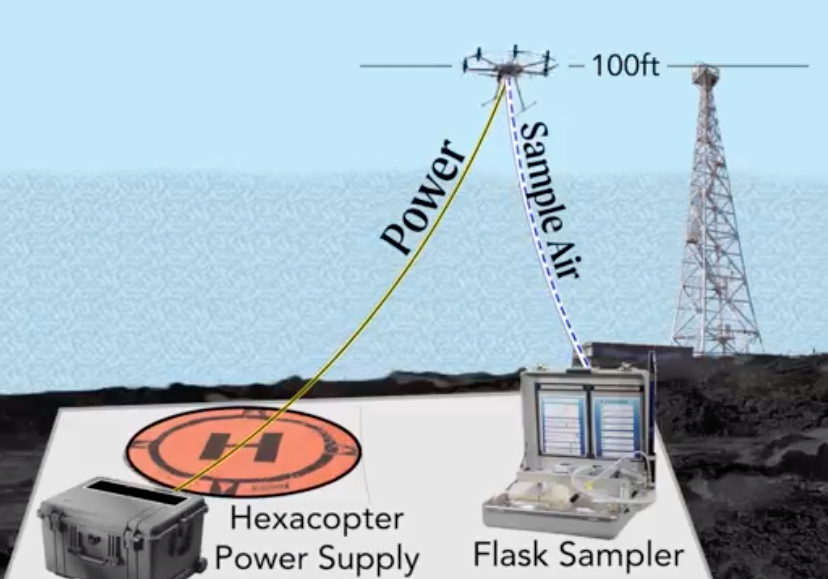
Uncrewed aerial systems (UAS) have long been heralded for their unique potential to sample the upper atmosphere at much lower costs and in environments unreachable by most aircraft. However, under normal flight rules, NOAA UAS can only fly up to 1,200 feet above ground level in the national airspace.

NOAA Global Monitoring Laboratory has recently obtained approval from the Federal Aviation Administration (FAA) to fly the High-altitude Operational Returning Unmanned System (HORUS) up to 90,000 ft above mean sea level (MSL) in the national airspace in northeastern Colorado.

HORUS is Approved to Fly in the National Airspace in Northeastern Colorado Read More »

Marine Debris Detection with UAS, Machine Learning, and Polarimetric Imaging

Marine debris, human-made material that is discarded or abandoned into the marine environment, is a pervasive problem plaguing shorelines around the world. Marine debris poses serious threats to wildlife, degrades coastal and marine environments, and can negatively impact the Blue Economy (e.g., tourism, shipping, and fisheries).  NOAA’s Marine Debris Program (MDP), as the U.S. Federal lead for assessment, prevention, and removal of debris, works with partners across the Nation  to conduct debris shoreline surveys to identify debris accumulations, locations, and sources as part of the Marine Debris Monitoring and Assessment Project (MDMAP).  Data from these surveys have been used to assess spatial and temporal trends in shoreline debris, inform behavior change campaigns focusing on specific items and assess the effectiveness of legislation targeting specific items. In this project, NOAA’s National Centers for Coastal Ocean Science (NCCOS), NOAA’s MDP, and Oregon State University (OSU) partnered to investigate three emerging technologies with the potential to transform how marine debris shoreline surveys are conducted: uncrewed aircraft systems (UxS), machine learning, and polarimetric imaging (PI) cameras.    

This innovative technology and corresponding operations were funded and supported by the OAR Uncrewed Systems Research Transition Office (UxSRTO).

Marine Debris Detection with UAS, Machine Learning, and Polarimetric Imaging Read More »

NOAA Completes FVR-55 Shipboard Launch/Recovery Operations to Measure Atmospheric Aerosols and Fluxes needed to Improve Climate Model Simulations

During the month of March 2022, the NOAA Pacific Marine Environmental Laboratory (PMEL) and Physical Sciences (PSL) Laboratories used a newly developed uncrewed aircraft system (UAS) to better understand the chemical and physical characteristics of the atmosphere. The suite of sensors used in these demonstrations will improve climate and weather models by providing unique information about the atmosphere.

In partnership with L3Harris Technologies, an American technology company, NOAA has used the newly developed FVR-55 (Fixed Wing Vertical Takeoff and Landing Rotator) UAS to conduct shipboard launch and recovery operations for collecting atmospheric data with the NOAA “Clear Sky,” “Cloudy Sky,” and “miniFlux'' scientific payloads. Development of this innovative technology was initially funded through a NOAA Phase I Small Business Innovation Research (SBIR) award in 2016, followed by a Phase II SBIR award and follow-on contract for the continued development of the UAS. Continued development and operations were funded and logistically supported by both the OAR Uncrewed Systems Research Transition Office (UxSRTO) and the OMAO UxS Operations Center (UxSOC). Participants from PMEL, PSL, UxSRTO, UxSOC, and L3Harris performed 11 fully autonomous ship-launching and landing flight operations (14.9 hours of total flight time) off Key West, FL to test and demonstrate the scientific payloads.

NOAA Completes FVR-55 Shipboard Launch/Recovery Operations to Measure Atmospheric Aerosols and Fluxes needed to Improve Climate Model Simulations Read More »

Steller sea lions hauled out on shore at Makushin Bay on Unalaska Island in Alaska. Credit: NOAA Fisheries.

Use of Artificial Intelligence (AI) to Monitor Steller Sea Lion Populations

Every year, Alaska Fisheries Science Center’s Marine Mammal Laboratory of NOAA Fisheries uses crewed and uncrewed systems to conduct aerial surveys of known Steller sea lion sites across Alaska. These surveys are essential to monitoring the endangered western population of Steller sea lions in Alaska. While the population as a whole has begun to show signs of recovery, one region in the westernmost part of the population range has declined 94% in the last 40 years (showing no signs of recovery), and rookeries – sites where sea lions mate, give birth, and rest – have begun to disappear. In the Gulf of Alaska, anomalous warm water events beginning in 2014 are becoming more commonplace and are likely causing the observed declines in the area – an area which was previously showing signs of sea lion population recovery and began to increase in 2002.

Use of Artificial Intelligence (AI) to Monitor Steller Sea Lion Populations Read More »

NOAA Global Monitoring Laboratory Development of a UAS “Virtual Tower” for Gas and Ozone Measurements

Scientists from NOAA’s Global Monitoring Laboratory (GML) have undertaken novel development of an uncrewed aircraft system (UAS) “hexacopter” that will enable the lab to not only recommence a long-standing mission that was recently forced to halt, but paves the way toward enhanced operations in the future. The composition of Earth’s atmosphere is rapidly changing due to anthropogenic releases of carbon dioxide (CO2) and methane (CH4), which are powerful greenhouse gasses driving global warming. Also, human-made chemicals such as CFC-11 and CFC-12 (refrigerants) are destroying the ozone layer that filters out ultraviolet (UV) radiation. These CFCs and their counterparts destroy enough of the protective stratospheric ozone layer to produce the Antarctic “Ozone Hole”.

NOAA Global Monitoring Laboratory Development of a UAS “Virtual Tower” for Gas and Ozone Measurements Read More »